


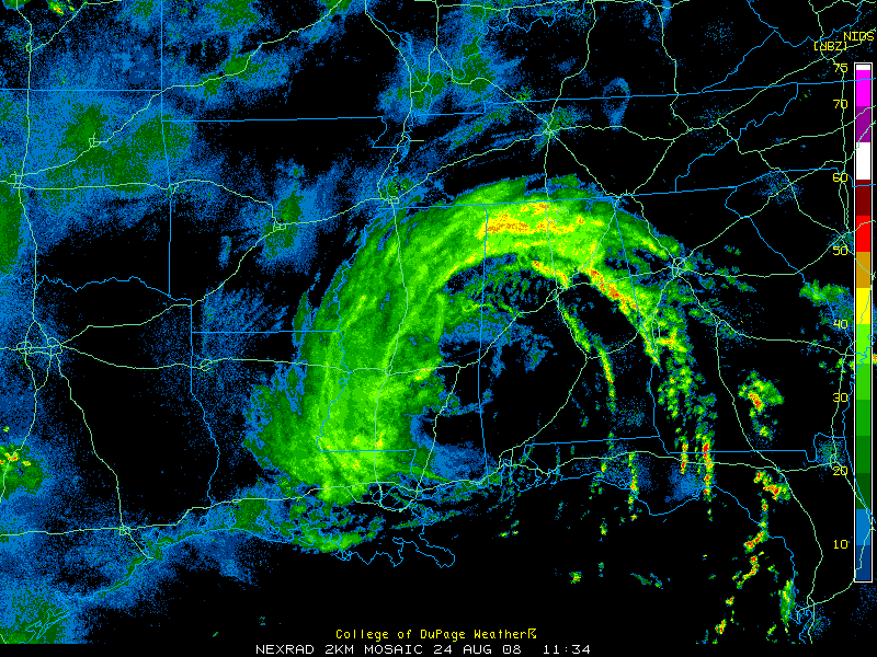
Wow. You get under one of these tropical rainbands and you will know it. Nearly three quarters of an inch here in Trussville in just 30 minutes. The rain is tapering off now, but we have 3.45 in the rain bucket since yesterday morning.
This is what we are talking about folks. Someone called Drought Busters and they sent us the Mega Package. Decaying tropical cyclones like Fay have brought some disastrous rains to the southeastern United States.
There was that 1916 hurricane that gave Birmingham its wettest July ever with 20.16 inches I think. Remember Alberto and its Biblical flooding in Georgia. And then there was Allison. The mark by which all tropical storms are known. That 2001 tropical storm never became a hurricane, and still did one billion dollars in damage, all from flooding. What about Floyd in 1998? He turned eastern North Carolina into a lake.
So, now we are faced with a potential system like one of those, hanging around for 3 to 5 days. Or who knows how long. Some places in Alabama are going to get some remarkable rainfall totals between now and Wednesday or Thursday.
Fay is a hybrid low now. Judging by surface observations, the center is along the Alabama/Mississippi border between Meridian, Hattiesburg, Mobile and Evergreen. (Boy, we need some more surface obseration sites in Southwest Alabama!) I would say the good folks in Quitman, Mississippi are waving at Fay as she pushes west of them.
The giant moisture pump that she is, Fay will draw in billions of tons of Gulf moisture today and start more of those wonderfully efficient rainmakers we call feeder bands later today. Nighttime is a favored time for these mosters of the midway to get their act together, so another big show may happen tonight.
And with a little heating today, more showers and storms will form. I would expect more lightning than today. And shear patterns favor the potential development of tornadoes, although that risk is somewhat marginal. A tornado watch does remain in effect for central and eastern Alabama until 9 a.m., watching those stronger rainbands for spin up tornadoes. Counties still in the watch are: continues Tornado Watch for Chambers, Clay and Randolph.
It feels tropical out there. Temperatures are in the lower 70s, dewpoints around 70 in the I-20 corridor. Highs should reach the lower 80s later today. Rain chances will be high. Our winds will be out of the east and southeast, diminishing slowly today The stronger winds are with that big rainband, currently gusting over 25 mph in many locations across the Tennessee Valley and over in Mississippi. A lake wind advisory continues for the northern two thirds of Alabama until 1 p.m.
Needless to say, all Alabama and Deep South residents need to mointor the latest forecasts, reports and warnings for flooding potential.



