


Interesting days ahead in the Weather Office, with Hanna getting ready to make a trek up the East Coast as a strong tropical storm (and a big one I might add) and an increasing threat from extremely dangerous Hurricane Ike. Josephine will not amount to anything.
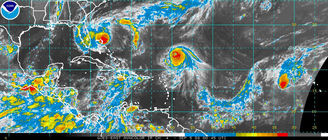
Hanna, Ike and Josephine are visible in this Atantic wide view tonight.
Here are the 10 p.m. notes…
TROPICAL STORM HANNA
Convection associated with Hanna seems to be increasing tonight. Forecasters gave Hanna the ultimate insult this afternoon. They said she was looking more subtropical than tropical. She has decided to show them with the increased convection near her center tonight. Still, lacking an inner core, rapid intensification is not expected. The center of the storm is over the northern Bahamas. Top winds are 65 mph, confirmed by a departing AF plane. Another will be in the storm overnight. The center is located about 540 miles south of Wilmington NC. Movement is NW-14. Projected landfall will be on the southwestern North Carolina coast during the predawn hours on Saturday. Projected intensity will be 70 mph (strong tropical storm.) But as Leonard Posttoasties always said, it ain’t over til its over.
HURRICANE IKE
Small but severe Hurricane Ike is 1,400 miles ESE of Miami late tonight. Movement is W-14 mph. It will start moving more west southwest soon. Top winds are 130 mph (category four.) It is undergoing some wind shear and will likely weaken over the next couple of days, perhaps back to a category two hurricane. But things will change by Sunday and we will have an intensifying hurricane in the southern Bahamas, pointed at South Florida. The official track carries it to very near the South Florida coast as a strong category three hurricane with top winds of 125 mph. Some of the models say it will be much, much stronger. Some of the models turn it out to sea. The European takes it into the Gulf. Forecast errors are very, very large at the 4-5 day time frame, so this one will bear watching by lots of folks…
TROPICAL STORM JOSEPHINE
The center is located over 1,500 miles east of the Lesser Antilles tonight. Movement is WNW-10 mph. Josephine is expected to continue moving on a west northwest track, passing north of the islands and recurving around the big subtropical Atlantic high. Top winds 45 mph. It is expected to weaken on Friday and might even be downgraded to a tropical depression, but some restrengthening should occur by early next week.
OTHER TROPICAL THREATS
Convection associated with a disturbance east of the Windward Islands has decreased tonight and there is a low probability that a tropical cyclone will form in this region. The GFS does expect at least one more named storm in the next two weeks as our busy tropical times continue.



