


Good bit of cloud cover across Alabama this morning, especially over the northwestern two thirds of the state. A weak convergence zone is over the area, and it is squeezing out some showers over East Central Alabama. They are weakening as they move east, but they dumped some one inch rainfall amounts over Shelby County. A nice treat on an early Saturday.
SKies should become partly cloudy and it will be warm across the area today with highs in the 80s. Expect clear skies and lower humidities overnight with lows dropping into the 60s. Tomorrow should be mostly sunny and hot with highs in the upper 80s to near 90.
HANNA
Zipping along through southeastern Virginia, moving at nearly 25 mph. Top winds 50 mph, but no sustained tropical storm force winds recently. Will move to near Long Island tonight and Boston in the early morning hours. Heavy rain in the northern side of the system with 6 inches reported around Raleigh. Hanna made landfall about 320 a.m. EDT on the South Carolina/North Carolina border.
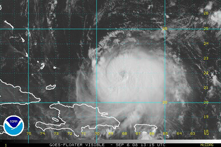
IKE
Ike is a category two hurricane with top winds now 110 mph. It is undergoing northeasterly wind shear and has subsequently weakened. It should strengthen later today as the shear lessens and the storm moves over warm water. Ike will spend Sunday moving over the Turks and Caicos and southern Bahamas, gradually describing a gentle curve to the right. Monday will be spent passing near or over Cuba. Cuba will weaken the hurricane again, but it will re-intensify when it moves over the southeastern Gulf.
The official forecast carries it into the Central Gulf on Tuesday some 300 miles south of Destin as a Category Three hurricane. Where it goes from there is up for conjecture. A frontal system is expected to miss the hurricane on Tuesday as it drops into the Southeast, leaving Ike to continue meandering northwestward. Another front is expected to drop into the Southeast on Friday, and that should do the trick, drawing the hurricane north and northeast. Just where it will make landfall is uncertain.
I could see this thing stalling ove rthe northern Gulf and waiting on the second front. Hopefully a couple of factors will go against it in the intensity department. Upwelling from Gustav and from itself if it stalls. And shear from the approaching trough. Hopefully, it will weaken, merge with the front and bring a widespread two day rain event to much of the Deep South.
But reality is that we will have a major hurricane in the Gulf with nowhere to go but to a landmass…and that spells potential trouble. It will be an interesting week.
Five recon flights into Ike today, including two high altitude GIV flights to sample the atmosphere in a wide area around the hurricane. This data is fed into the weather forecasting models in an attempt to give them better initial data. It generally yields better forecasts. Also, all NWS offices in the southeastern U.S. will start doing two additional balloon launches each stay starting at 1 p.m. CDT today.



