


Our “cold season” is getting off to a cold start, with temperatures in Birmingham running below their 112-year averages for much of October and November, and more cold air coming in this week and next week. Here is a chart of high temperatures (red) and low temperatures (blue) at Birmingham Airport since October 1. The average high and low, based on 1896 to 2007, are shown as dashed lines.
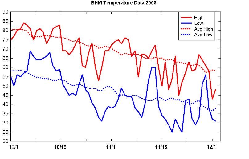
Notice that we have had a lot of days and nights with below-average temperatures. 40 of the 63 nights in this survey were colder than their long-term averages. Interestingly, this is at the Birmingham Airport on the urban heat island, where on clear, calm nights, it may be 5 degrees warmer than the surrounding areas. Take a look at 2 am temperatures this morning:
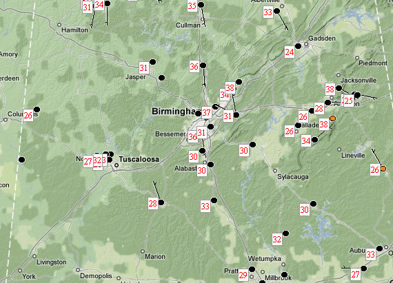
It was 37 at the Birmingham Airport, where the official record is taken, but 28 in Tuscaloosa and Anniston, and 24 in Gadsden. Even in the BHM metro, it was 30 at the NWS in Calera, and 31 in Leeds. Has there been a heat island at BHM since 1896? Probably. And, the temperature location has been moved some. But the heat island may not have necessarily always been this pronounced, which may cause our temperatures in recent years at BHM to have a slight warm bias. It would be interesting to study the effect of an expanding metro area on the intensity of the heat island in the center, and also to compare the long term changes at BHM with those at Pinson. These are questions better answered by Dr. John Christy, world-recognized climate expert, Alabama state climatologist, and UAH researcher.
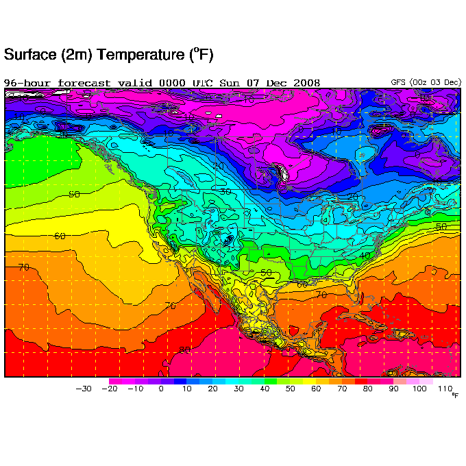
As far as the cold air on the way, the early and vast snow cover over Alaska, Canada, and parts of the continental U.S. may lead to an unusually cold winter. The NWS in Fairbanks, Alaska issued a Special Weather Statement about the extreme cold in Alaska…midnight CST observations indicate temperatures in the -20s and -30s well south into Alaska and NW Canada, below the Arctic Circle. The next cold front will move through most of Alabama Thursday, giving us another day on Friday with highs only in the 40s. Lows will drop below freezing again Friday morning. Additional cold fronts will also move through late Saturday and early next week, possibly keeping daytime temperatures in the 30s some days. Here is the GFS forecast for surface temperatures Saturday evening at 6 pm. Notice the large area of temperatures below zero!
This is a pattern we’ll have to continue to watch. I know most people want a snowfall…we’ll just have to see.



