


…A SEVERE THUNDERSTORM WARNING REMAINS IN EFFECT UNTIL 530 PM CDT FOR NORTHWESTERN JACKSON…NORTHEASTERN MADISON AND SOUTH CENTRAL FRANKLIN COUNTIES… At 519 PM CDT, a severe thunderstorm was located 7 miles southeast of New Market, or 11 miles east of Moores Mill, moving northeast at 55 mph.
HAZARD…60 mph wind gusts and quarter size hail.
SOURCE…Radar indicated. This cluster of storms has a history of producing hail to the size of quarters earlier in central and eastern Madison County.
IMPACT…Hail damage to vehicles is expected. Expect wind damage to roofs, siding, and trees. Locations impacted include… Hytop, Francisco, Princeton, Jericho, Estillfork and Larkin.
Severe Thunderstorm Warning Continues For Parts Of Jackson, Madison, And Franklin (TN) Counties Until 5:30PM
Apr 5th @ 4:59 pm
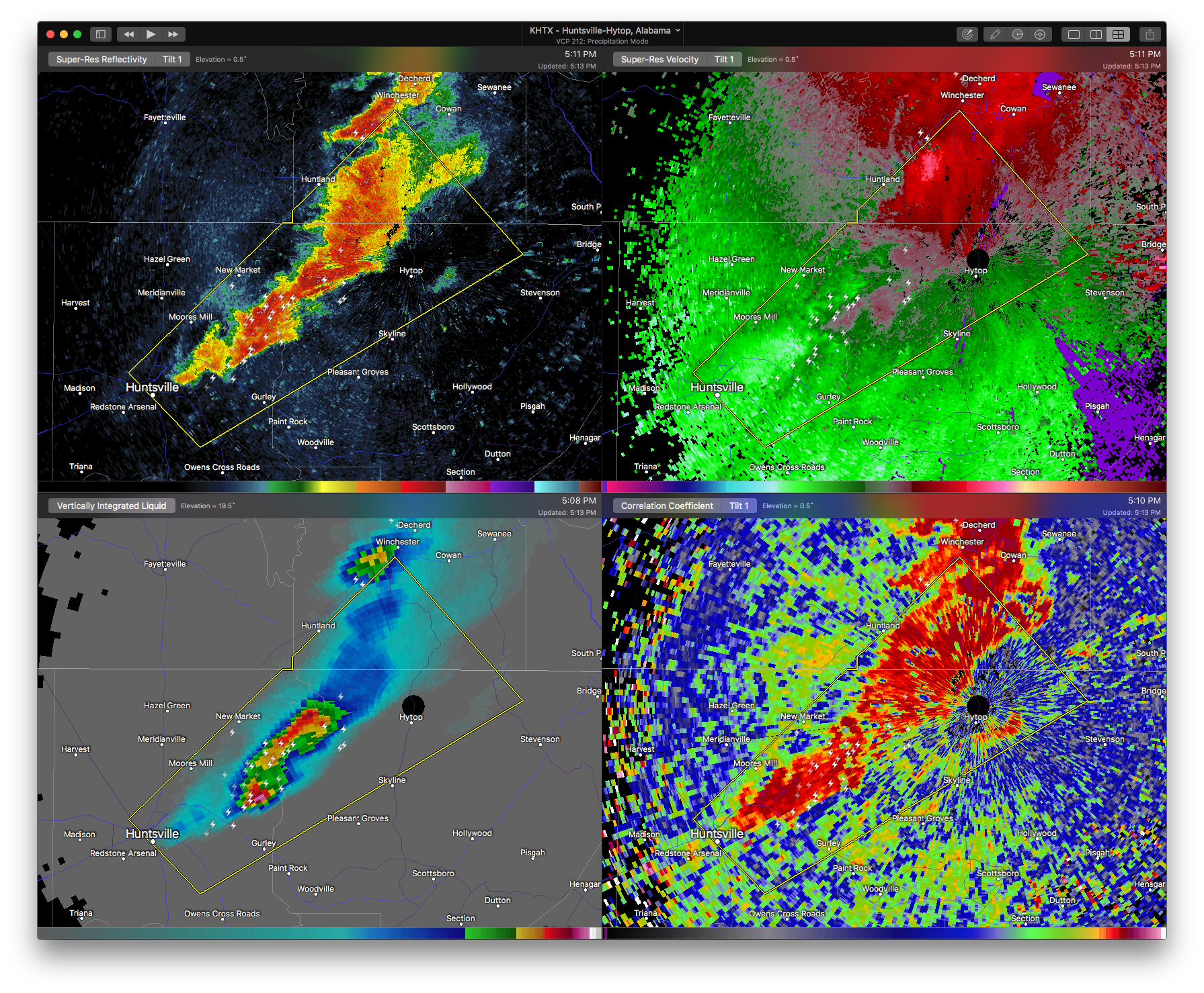

…A SEVERE THUNDERSTORM WARNING REMAINS IN EFFECT UNTIL 530 PM CDT FOR NORTHWESTERN JACKSON…NORTHEASTERN MADISON AND SOUTHWESTERN FRANKLIN COUNTIES… At 511 PM CDT, a severe thunderstorm was located near New Market, or 9 miles east of Moores Mill, moving northeast at 55 mph. Another severe thunderstorm was located 2 miles east of New Market in extreme northwest Jackson County, also moving northeast at 55 MPH.
HAZARD…60 mph wind gusts and quarter size hail.
SOURCE…Public. These storms have a history of producing hail to the size of quarters across Madison County.
IMPACT…Hail damage to vehicles is expected. Expect wind damage to roofs, siding, and trees. Locations impacted include… Moores Mill, Huntland, New Market, Hytop, Jericho, Larkin, Francisco, Beans Creek, Ryland and Maysville.
Severe Thunderstorm Warning Issued For Parts Of Jackson, Madison, And Franklin (TN) Counties Until 5:30PM
Apr 5th @ 4:59 pm

The National Weather Service in Huntsville Alabama has issued a
* Severe Thunderstorm Warning for…
Northwestern Jackson County in northeastern Alabama…
Northeastern Madison County in north central Alabama…
Southwestern Franklin County in Middle Tennessee…
* Until 530 PM CDT
* At 456 PM CDT, a severe thunderstorm was located near Huntsville, moving northeast at 60 mph. Another severe thunderstorm was located near Ryland, moving northeast at 60 MPH.
HAZARD…60 mph wind gusts and quarter size hail.
SOURCE…Public. At 455 PM, hail to the size of quarters was reported in the Medical District of Huntsville. At 454
PM, hail to the size of nickels was reported near Ryland.
IMPACT…Hail damage to vehicles is expected. Expect wind damage to roofs, siding, and trees.
* Locations impacted include…
Northern Huntsville, Moores Mill, Huntland, Skyline, Gurley, Alabama A And M University, New Market, Hytop, Jericho and Larkin.



