


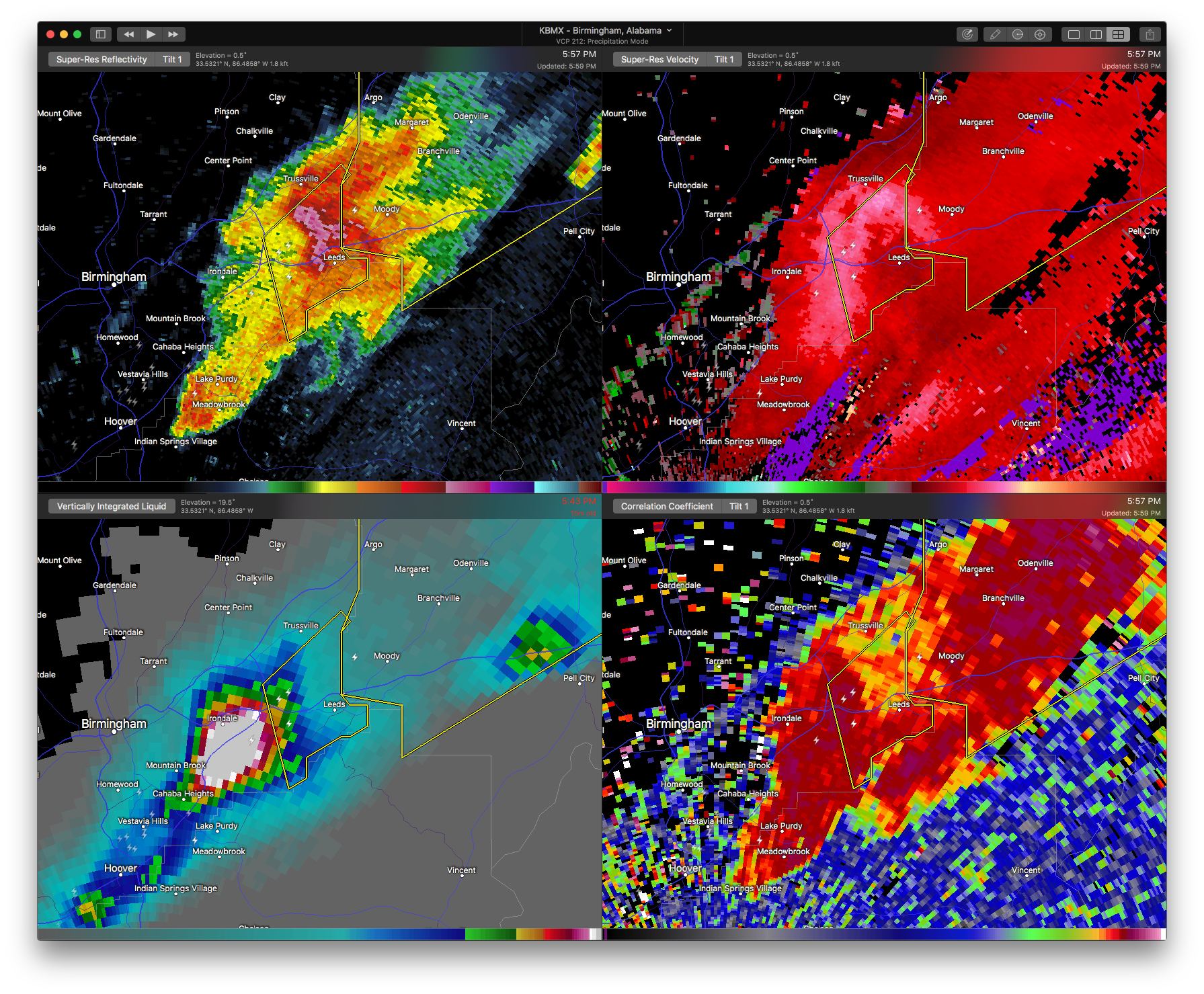

…A SEVERE THUNDERSTORM WARNING REMAINS IN EFFECT UNTIL 615 PM CDT FOR EAST CENTRAL JEFFERSON COUNTY… At 557 PM CDT, a severe thunderstorm was located over Leeds, moving northeast at 55 mph.
HAZARD…Golf ball size hail and 60 mph wind gusts.
SOURCE…Radar indicated.
IMPACT…People and animals outdoors will be injured. Expect hail damage to roofs, siding, windows, and vehicles. Expect wind damage to roofs, siding, and trees. Locations impacted include… Birmingham, Trussville, Leeds, Moody, Barber Motorsports Park and Shops Of Grand River.
Severe Thunderstorm Warning Canceled For Parts Of Shelby County
Apr 5th @ 5:30 pm
…THE SEVERE THUNDERSTORM WARNING FOR NORTH CENTRAL SHELBY COUNTY IS CANCELLED… The severe thunderstorm which prompted the warning has moved out of the warned area. Therefore, the warning has been cancelled. A tornado watch remains in effect until 900 PM CDT for Alabama.
Severe Thunderstorm Warning Continues For Parts Of Jefferson And Shelby Counties Until 6:15PM
Apr 5th @ 5:30 pm
Large hail is falling in the I-459 Corridor in southern Metro Birmingham. We experienced waurter sied hail here for nearly ten minutes.
The core is near Liberty Park at 550 p.m.
It will impact the I-459/20 interchange, Irondale and Leeds and Moody as it moves northeast.

…A SEVERE THUNDERSTORM WARNING REMAINS IN EFFECT UNTIL 615 PM CDT FOR NORTH CENTRAL SHELBY AND SOUTHEASTERN JEFFERSON COUNTIES… At 541 PM CDT, a severe thunderstorm was located over The Summit, or over Vestavia Hills, moving northeast at 55 mph. Large hail has been reported with this storm.
HAZARD…Golf ball size hail and 60 mph wind gusts.
SOURCE…Radar indicated.
IMPACT…People and animals outdoors will be injured. Expect hail damage to roofs, siding, windows, and vehicles. Expect wind damage to roofs, siding, and trees. Locations impacted include… Birmingham, Hoover, Vestavia Hills, Homewood, Mountain Brook, Trussville, Irondale, Leeds, Moody, Indian Springs Village, Cahaba Heights, Patton Creek, Barber Motorsports Park, Shops Of Grand River, The Summit, Lake Purdy, Riverchase Galleria, Greystone, Meadowbrook and Vandiver.
Severe Thunderstorm Warning Continues For Parts Of Jefferson And Shelby Counties Until 6:15PM
Apr 5th @ 5:30 pm

…A SEVERE THUNDERSTORM WARNING REMAINS IN EFFECT UNTIL 615 PM CDT FOR NORTHERN SHELBY AND SOUTHEASTERN JEFFERSON COUNTIES… At 535 PM CDT, a severe thunderstorm was located over Riverchase Galleria, or over Hoover, moving northeast at 55 mph.
HAZARD…Golf ball size hail and 60 mph wind gusts.
SOURCE…Radar indicated.
IMPACT…People and animals outdoors will be injured. Expect hail damage to roofs, siding, windows, and vehicles. Expect wind damage to roofs, siding, and trees. Locations impacted include… Birmingham, Hoover, Vestavia Hills, Bessemer, Homewood, Pelham, Mountain Brook, Trussville, Helena, Irondale, Leeds, Moody, Chelsea, Indian Springs Village, Vincent, Regions Park Or Hoover Met, Oak Mountain State Park, Vandiver, Barber Motorsports Park and Shops Of Grand River.
Severe Thunderstorm Warning Issued For Parts Of Jefferson And Shelby Counties Until 6:15PM
Apr 5th @ 5:30 pm
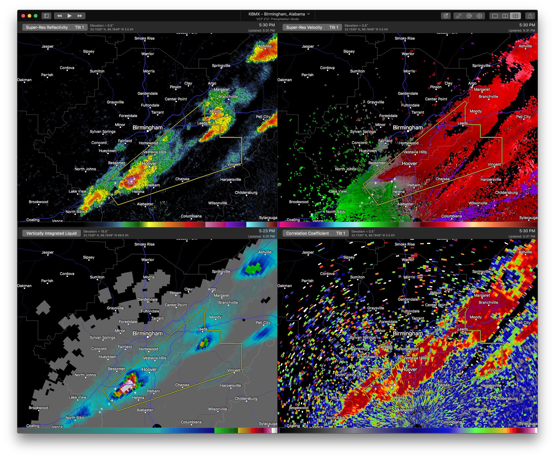

The National Weather Service in Birmingham has issued a
* Severe Thunderstorm Warning for…
Northern Shelby County in Alabama…
Southeastern Jefferson County in Alabama…
* Until 615 PM CDT
* At 529 PM CDT, a severe thunderstorm was located over Regions Park
Or Hoover Met, or over Helena, moving northeast at 55 mph.
HAZARD…60 mph wind gusts and quarter size hail.
SOURCE…Public.
IMPACT…Hail damage to vehicles is expected. Expect wind damage to roofs, siding, and trees.
* Locations impacted include…
Birmingham, Hoover, Vestavia Hills, Bessemer, Homewood, Pelham, Mountain Brook, Trussville, Helena, Irondale, Leeds, Moody, Chelsea, Indian Springs Village, Vincent, Regions Park Or Hoover
Met, Oak Mountain State Park, Vandiver, Barber Motorsports Park and
Shops Of Grand River.



