


…THE SEVERE THUNDERSTORM WARNING FOR DEKALB COUNTY IS CANCELLED… The storms which prompted the warning have moved out of the area. Therefore the warning has been cancelled. However gusty winds are still possible with these thunderstorms. Remember, a Severe Thunderstorm Warning still remains in effect for much of the remainder of DeKalb County. This warning only expires the far southern portion of DeKalb County, generally south of the Crossville area.
Severe Thunderstorm Warning Continues For Parts Of Dekalb County Until 3:30PM
Jun 15th @ 2:49 pm

…A SEVERE THUNDERSTORM WARNING REMAINS IN EFFECT UNTIL 330 PM CDT FOR SOUTHERN DEKALB COUNTY… At 312 PM CDT, severe thunderstorms were located along a line extending from Valley Head to near Fort Payne to near Crossville, moving southeast at 30 mph.
HAZARD…60 mph wind gusts.
SOURCE…Radar indicated.
IMPACT…Expect damage to roofs, siding, and trees. Locations impacted include… Fort Payne, Rainsville, Little River Canyon National Preserve, Collinsville, Crossville, Geraldine, Little River Falls, Valley Head, Hammondville and Mentone.
Severe Thunderstorm Warning Continues For Parts Of Dekalb County Until 3:30PM
Jun 15th @ 2:49 pm

…A SEVERE THUNDERSTORM WARNING REMAINS IN EFFECT UNTIL 330 PM CDT FOR DEKALB COUNTY… At 302 PM CDT, severe thunderstorms were located along a line extending from 7 miles northeast of Ider to near Sylvania to near Geraldine, moving southeast at 20 mph.
HAZARD…60 mph wind gusts.
SOURCE…Radar indicated.
IMPACT…Expect damage to roofs, siding, and trees. Locations impacted include… Fort Payne, Rainsville, Little River Canyon National Preserve, Henagar, Collinsville, Crossville, Sylvania, Fyffe, Powell and Geraldine.
Severe Thunderstorm Warning Canceled For Parts Of Jackson And Marshall Counties
Jun 15th @ 2:49 pm
…THE SEVERE THUNDERSTORM WARNING FOR EASTERN JACKSON AND EAST CENTRAL MARSHALL COUNTIES IS CANCELLED… The storms which prompted the warning have moved out of the warned area. Therefore, the warning has been cancelled.
Severe Thunderstorm Warning Issued For Parts Of Dekalb, Jackson, And Marshall Counties Until 3:30PM
Jun 15th @ 2:49 pm
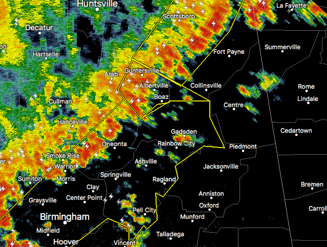

The National Weather Service in Huntsville Alabama has issued a
* Severe Thunderstorm Warning for…
Eastern Jackson County in northeastern Alabama…
East central Marshall County in northeastern Alabama…
DeKalb County in northeastern Alabama…
* Until 330 PM CDT
* At 247 PM CDT, severe thunderstorms were located along a line extending from 7 miles south of Bridgeport to near Sylvania to 8 miles northwest of Geraldine, moving southeast at 40 mph.
HAZARD…60 mph wind gusts.
SOURCE…Radar indicated.
IMPACT…Expect damage to roofs, siding, and trees.
* Locations impacted include…
Fort Payne, Guntersville, Rainsville, Little River Canyon National
Preserve, Henagar, Collinsville, Crossville, Sylvania, Fyffe and
Powell.



