


…THE SEVERE THUNDERSTORM WARNING FOR CENTRAL MARION AND LAMAR
COUNTIES WILL EXPIRE AT 115 PM CDT…
The storms which prompted the warning have moved out of the area.
Therefore the warning will be allowed to expire.
A tornado watch remains in effect until 800 PM CDT for northwestern
and west central Alabama.
Severe Thunderstorm Warning Continues For Parts Of Lamar And Marion Counties Until 1:15PM
Jun 23rd @ 12:16 pm

…A SEVERE THUNDERSTORM WARNING REMAINS IN EFFECT UNTIL 115 PM CDT FOR CENTRAL MARION AND LAMAR COUNTIES… At 109 PM CDT, severe thunderstorms were located along a line extending from Hackleburg to near Gu- Win to near Bluff, moving east at 45 mph.
HAZARD…60 mph wind gusts.
SOURCE…Radar indicated.
IMPACT…Expect damage to roofs, siding, and trees. Locations impacted include… Hamilton, Vernon, Sulligent, Millport, Guin, Kennedy, Beaverton, Blooming Grove, Lamar County Airport, Crews, Bedford, Cody, Lamar County Public Lake, Rankin Fite Airport, Star, Marion County Public Lake, Hightogy, Melborne and Pikeville.
Severe Thunderstorm Warning Continues For Parts Of Lamar And Marion Counties Until 1:15PM
Jun 23rd @ 12:16 pm

…A SEVERE THUNDERSTORM WARNING REMAINS IN EFFECT UNTIL 115 PM CDT FOR WESTERN MARION AND LAMAR COUNTIES… At 1254 PM CDT, severe thunderstorms were located along a line extending from 6 miles northeast of Weston to near Beaverton to near Vernon, moving east at 45 mph.
HAZARD…60 mph wind gusts.
SOURCE…Radar indicated.
IMPACT…Expect damage to roofs, siding, and trees. Locations impacted include… Hamilton, Vernon, Sulligent, Millport, Guin, Kennedy, Detroit, Beaverton, Weston, Blooming Grove, Lamar County Airport, Crews, Bedford, Cody, Henson Springs, Rankin Fite Airport, Star, Pine Springs, Marion County Public Lake and Hightogy.
Severe Thunderstorm Warning Continues For Parts Of Lamar And Marion Counties Until 1:15PM
Jun 23rd @ 12:16 pm

…A SEVERE THUNDERSTORM WARNING REMAINS IN EFFECT UNTIL 115 PM CDT FOR WESTERN MARION AND LAMAR COUNTIES… At 1226 PM CDT, severe thunderstorms were located along a line extending from near New Salem to 8 miles northwest of Bedford to near Kolola Springs, moving east at 45 mph. At 1225 PM CDT, Broadcast media reports multiple power lines down in Monroe County in Mississippi.
HAZARD…60 mph wind gusts.
SOURCE…Broadcast Media.
IMPACT…Expect damage to roofs, siding, and trees. Locations impacted include… Hamilton, Vernon, Sulligent, Millport, Guin, Kennedy, Detroit, Beaverton, Weston, Blooming Grove, Lamar County Airport, Crews, Bedford, Cody, Henson Springs, Rankin Fite Airport, Star, Pine Springs, Marion County Public Lake and Hightogy.
Severe Thunderstorm Warning Issued For Parts Of Lamar And Marion Counties Until 1:15PM
Jun 23rd @ 12:16 pm
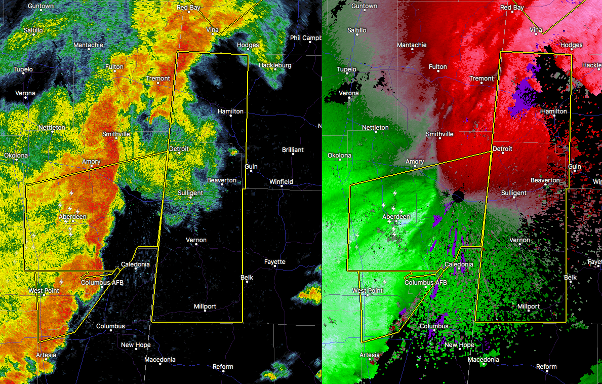

The National Weather Service in Birmingham has issued a
* Severe Thunderstorm Warning for…
Western Marion County in northwestern Alabama…
Lamar County in west central Alabama…
* Until 115 PM CDT
* At 1214 PM CDT, severe thunderstorms were located along a line extending from near Smithville to near Aberdeen to Waverly, moving east at 45 mph.
HAZARD…60 mph wind gusts.
SOURCE…Radar indicated.
IMPACT…Expect damage to roofs, siding, and trees.
* Locations impacted include…
Hamilton, Vernon, Sulligent, Millport, Guin, Kennedy, Detroit, Beaverton, Weston, Blooming Grove, Lamar County Airport, Crews, Bedford, Cody, Henson Springs, Rankin Fite Airport, Star, Pine
Springs, Marion County Public Lake and Hightogy.



