…A SEVERE THUNDERSTORM WARNING REMAINS IN EFFECT UNTIL 545 PM CDT FOR NORTHEASTERN TALLADEGA COUNTY… At 532 PM CDT, a severe thunderstorm was located over Oxford, moving east at 30 mph.
HAZARD…60 mph wind gusts.
SOURCE…Radar indicated.
IMPACT…Expect damage to roofs, siding, and trees. Locations impacted include… Oxford.
Severe Thunderstorm Warning Continues For Parts Of Talladega County Until 5:45PM
Jul 6th @ 4:47 pm

…A SEVERE THUNDERSTORM WARNING REMAINS IN EFFECT UNTIL 545 PM CDT FOR NORTHEASTERN TALLADEGA COUNTY… At 519 PM CDT, severe thunderstorms were located along a line extending from Bynum to near Grant Town to Waldo, moving east at 30 mph.
HAZARD…60 mph wind gusts.
SOURCE…Radar indicated.
IMPACT…Expect damage to roofs, siding, and trees. Locations impacted include… Oxford, Munford, Waldo, Grant Town, Camp Mac, Ironaton and Jenifer.
Severe Thunderstorm Warning Continues For Parts Of Talladega County Until 5:45PM
Jul 6th @ 4:47 pm

…A SEVERE THUNDERSTORM WARNING REMAINS IN EFFECT UNTIL 545 PM CDT FOR NORTHEASTERN TALLADEGA COUNTY… At 513 PM CDT, severe thunderstorms were located along a line extending from Bynum to near Munford to Winterboro, moving east at 30 mph.
HAZARD…60 mph wind gusts and penny size hail.
SOURCE…Radar indicated.
IMPACT…Expect damage to roofs, siding, and trees. Locations impacted include… Oxford, Talladega, Munford, Waldo, Grant Town, Alpine, Talladega Municipal Airport, Camp Mac, Ironaton, Jenifer and Eastaboga.
Severe Thunderstorm Warning Continues For Parts Of Talladega County Until 5:45PM
Jul 6th @ 4:47 pm

…A SEVERE THUNDERSTORM WARNING REMAINS IN EFFECT UNTIL 545 PM CDT FOR CENTRAL TALLADEGA COUNTY… At 502 PM CDT, severe thunderstorms were located along a line extending from near Talladega Municipal Airport to near Talladega Superspeedway to near Alpine, moving east at 30 mph.
HAZARD…60 mph wind gusts and penny size hail.
SOURCE…Radar indicated.
IMPACT…Expect damage to roofs, siding, and trees. Locations impacted include… Oxford, Talladega, Lincoln, Munford, Waldo, Grant Town, Alpine, Talladega Superspeedway, Honda Manufacturing Of Alabama, Talladega Municipal Airport, Eastaboga, Camp Mac, Jackson Shoals, Ironaton, Jenifer and Howells Cove.
Severe Thunderstorm Warning Canceled For Parts Of St. Clair County
Jul 6th @ 4:47 pm
…THE SEVERE THUNDERSTORM WARNING FOR SOUTH CENTRAL ST. CLAIR COUNTY IS CANCELLED… The storms which prompted the warning have moved out of the warned area. Therefore, the warning has been cancelled.
Severe Thunderstorm Warning Continues For Parts Of St. Clair And Talladega Counties Until 5:45PM
Jul 6th @ 4:47 pm

…A SEVERE THUNDERSTORM WARNING REMAINS IN EFFECT UNTIL 545 PM CDT FOR CENTRAL TALLADEGA AND SOUTH CENTRAL ST. CLAIR COUNTIES… At 455 PM CDT, severe thunderstorms were located along a line extending from near Honda Manufacturing Of Alabama to near Talladega to near Logan Martin Dam, moving east at 35 mph.
HAZARD…60 mph wind gusts and penny size hail.
SOURCE…Radar indicated.
IMPACT…Expect damage to roofs, siding, and trees. Locations impacted include… Oxford, Talladega, Pell City, Lincoln, Riverside, Vincent, Munford, Waldo, Alpine Bay Resort, Talladega Superspeedway, Talladega Municipal Airport, Grant Town, Alpine, Honda Manufacturing Of Alabama, Coosa Island, Logan Martin Dam, Country Club Estates, Camp Mac, Jackson Shoals and Ironaton.
Severe Thunderstorm Warning Issued For Parts Of St. Clair And Talladega Counties Until 5:45PM
Jul 6th @ 4:47 pm
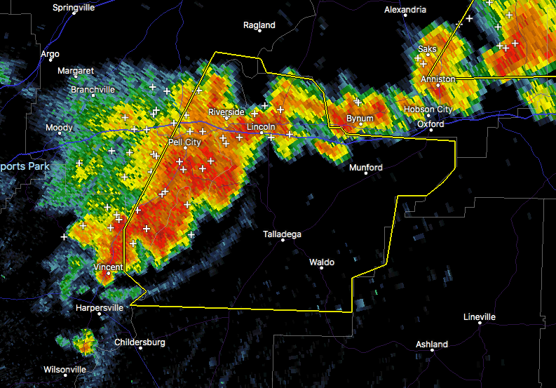

The National Weather Service in Birmingham has issued a
* Severe Thunderstorm Warning for…
Central Talladega County in east central Alabama…
Southeastern St. Clair County in Alabama…
* Until 545 PM CDT
* At 447 PM CDT, severe thunderstorms were located along a line extending from Honda Manufacturing Of Alabama to near Logan Martin
Dam, moving east at 30 mph.
HAZARD…60 mph wind gusts and penny size hail.
SOURCE…Radar indicated.
IMPACT…Expect damage to roofs, siding, and trees.
* Locations impacted include…
Oxford, Talladega, Pell City, Lincoln, Riverside, Vincent, Munford, Waldo, Alpine Bay Resort, Talladega Superspeedway, Talladega
Municipal Airport, Grant Town, Alpine, Honda Manufacturing Of
Alabama, Coosa Island, Logan Martin Dam, Country Club Estates, Camp
Mac, Jackson Shoals and Ironaton.