


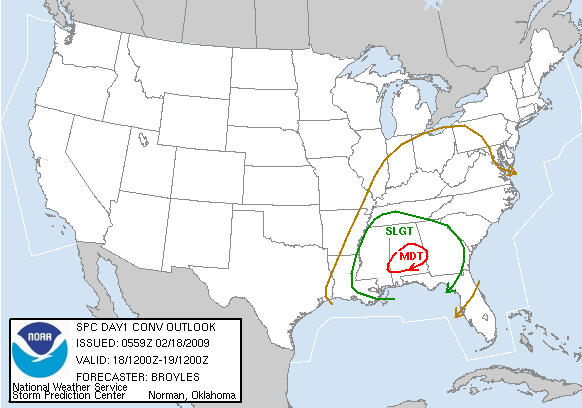
The new day 1 convective outlook just came out from the Storm Prediction Center…moderate risk over a small area in south-central Alabama, including Demopolis, Clanton, Auburn, Montgomery, and Troy. The rest of the state is in slight risk.
Very complicated pattern. Area radars show scattered thunderstorms early this morning over northern Alabama and Mississippi, despite surface temperatures in the 50s, as warm air feeds northward just above the surface underneath cold air at 20,000 feet. Strong low-level wind field is also setting up over Alabama this morning, with 55 mph winds at 2,000 feet.
It’s hard to tell how things will develop today, as it seems like the best wind shear will be moving out by noon, and the best instability moves in during the afternoon. However, enough wind shear will still be around as temperatures warm up some this afternoon and some storms may become severe. The main threat over north Alabama, north of I-20, will be large hail and damaging straight-line wind, although an isolated tornado can’t be ruled out.
The biggest threat is over south Alabama…Brian Peters and I discussed this earlier and pinpointed the area from Jackson, MS to Montgomery as the area with the highest probability of tornadoes (we agreed with SPC before their moderate risk came out). The reasoning is that morning rain over north and central Alabama will keep it in the 60s here, and sun in south Alabama could allow temepratures in the mid 70s, setting up a boundary, or miniature cold front near MGM. Those boundaries tend to focus severe weather. Also, dewpoints in south Alabama could reach 65 by late afternoon. If this situation develops tornadoes are likely in south Alabama.
Everyone needs to have a source of weather information today. Storms could affect north Alabama anytime. NOAA weather radios are good in that most of them will alert you when warnings are issued. Brian and I may head to Montgomery late this morning, and have a west route on US-80, a south route on US 331 or I-65, and an east route on I-85.
Then there’s a chance for snow this weekend, as a cold front comes through and then an upper-level disturbance moves in. All models are now showing snow in BHM this weekend. The GFS shows 2″ Saturday evening. The Canadian and European show a Gulf low developing, with amounts over 4″ possible. The NOGAPS and UKMET both show snow. The models could be wrong. We’ll see.



