


**Dangerous tornadic storms continue over parts of central and south Alabama. Please scroll down for details on that.**
This email addresses flooding, the main concern along I-20 tonight, and the possible snow tomorrow night. Below is the radar-estimated rainfall so far today, from BHM and Columbus, MS radars. Several areas over 4″.
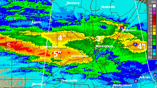
The radar seems to be doing fairly well (maybe a little low)…it indicates 2.25″ in Trussville, and so far I’ve measured 2.63″ here. Rainfall totals will probably average 3″ when this is over, with many locations over 5″. The NWS has received dozens of reports of roads flooded. With rain continuing this evening, flooding may only worsen, and flooding is especially dangerous at night. Please don’t drive into areas where the water is over the road, even if it looks shallow. Find another route. And if you live in a flood-prone area, keep an eye on things overnight.
The computer models have come back around to their earlier predictions of snow tomorrow night and Sunday in Alabama. I haven’t had a chance to analyze the models in depth, but here are the latest snowfall amounts from each model: NAM 5″, GFS 2″, GEM 1″, UKMET 1″. The upper-level low will bring plenty of cold air for snow, all the way to the Gulf Coast. The question is still moisture. The models continue to be inconsistent in their handling of the system, going from little or nothing on one model run to significant accumulations on the next. So, we still don’t know. But, the chances look better now since we are only 1-2 days away. Even if it the snow occurs, warm ground temperatures and it taking time for the cold air to come in should delay any road problems in the BHM area until after 11 pm tomorrow night.



