


Below is the output of the high resolution RPM model, which is exclusive to us through our weather graphics vendor, WSI. This is valid through 12:00 noon tomorrow:

This model is not as aggressive with snow amounts here. However, look at the 12Z WRF NMM, valid at 9:00 a.m tomorrow:
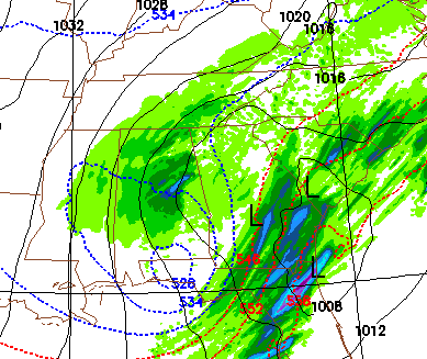
That output, needless to say, suggests a significant snow here.
But, forget the models, about time to look out the window. Here is the reflectivity to the northwest:

You can see the heaviest snow will depend on the deformation axis that sets up… there is no doubt the snow accumulation won’t be uniform across our state, and again I suggest we won’t know where the best snow accumulation potential will be until we see this thing in our sight tonight.
And, this meso update on heavy snow from SPC
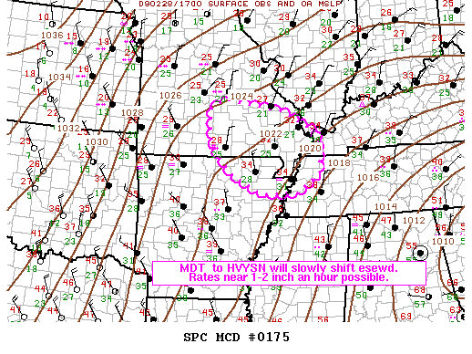
MESOSCALE DISCUSSION 0175
NWS STORM PREDICTION CENTER NORMAN OK
1147 AM CST SAT FEB 28 2009
AREAS AFFECTED…SERN MO…NERN AR…WRN TN/KY
CONCERNING…HEAVY SNOW
VALID 281747Z – 282145Z
MODERATE TO HEAVY SNOW HAS OCCASIONALLY BEEN OBSERVED ACROSS S CNTRL
MO OVER THE PAST FEW HOURS…WITH A RECENT REPORT OF 2 INCHES AN
HOUR AT FT WOOD. ANTICIPATE THIS TREND TO CONTINUE ESEWD TOWARD SERN
MO…NERN AR…AND WRN TN/KY. RATES OF NEAR 1 TO 2 INCHES AN HOUR
CAN BE EXPECTED IN HEAVIER SNOWFALL IN ADDITION TO RESTRICTED
VISIBILITIES.
A VIGOROUS UPPER LOW…CURRENTLY LOCATED OVER ERN KS…WILL QUICKLY
DIVE SEWD REACHING CNTRL AR BY 00Z. AT THE SURFACE…STRONG ARCTIC
HIGH PRESSURE IS QUICKLY BUILDING ACROSS THE CNTRL STATES…AND
SUBFREEZING TEMPERATURES WILL REMAIN ACROSS THE OUTLINE AREA WHILE
AREAS TO THE SOUTH AND EAST WILL QUICKLY COOL THROUGH THE AFTERNOON
IN STRONG COLD AIR ADVECTION. A NW TO SE ORIENTED BAND OF MDT/HVY
SNOW IS OCCURRING AHEAD OF THE UPPER LOW…WITH ADDITIONAL
DEVELOPMENT BEGINNING INTO SERN MO…WRN KY/TN…AND NERN AR ALONG
AN INVERTED SURFACE TROUGH AXIS AND IN CONJUNCTION WITH STRONG UPPER
DIVERGENCE/FAVORABLE JET DYNAMICS. SUBTLE ISENTROPIC LIFT IS
CONTRIBUTING AS WELL…WITH RELATIVE WARM/MOIST AIR TO THE EAST
BEING DRAWN ATOP THE ARCTIC AIRMASS/SUBFREEZING TEMPERATURES TO THE
WEST. THIS IS REFLECTED WELL IN RECENT PADUCAH VAD WIND PROFILES.
12Z SPRINGFIELD SOUNDING SHOWS SATURATED COLUMN GENERALLY FROM THE
SURFACE THROUGH 500 MB…AND MODEL SOUNDINGS ARE INDICATIVE THAT
AREAS IMMEDIATELY DOWNSTREAM WILL REMAIN SATURATED AS
WELL…PROMOTING MDT/HVY SNOW. EXPECT THIS TREND TO GENERALLY SHIFT
ESEWD IN CONJUNCTION WITH THE MOVEMENT OF THE UPPER LOW.
Cold core upper low, weatherman’s woe. Nobody knows how this will play out, even at this hour, but confidence is increasing in accumulation snow (grassy areas) for much of North and Central Alabama. Most roads will be just wet, but there could be some travel issues in the narrow axis of the heavier snow. Stay tuned…



