


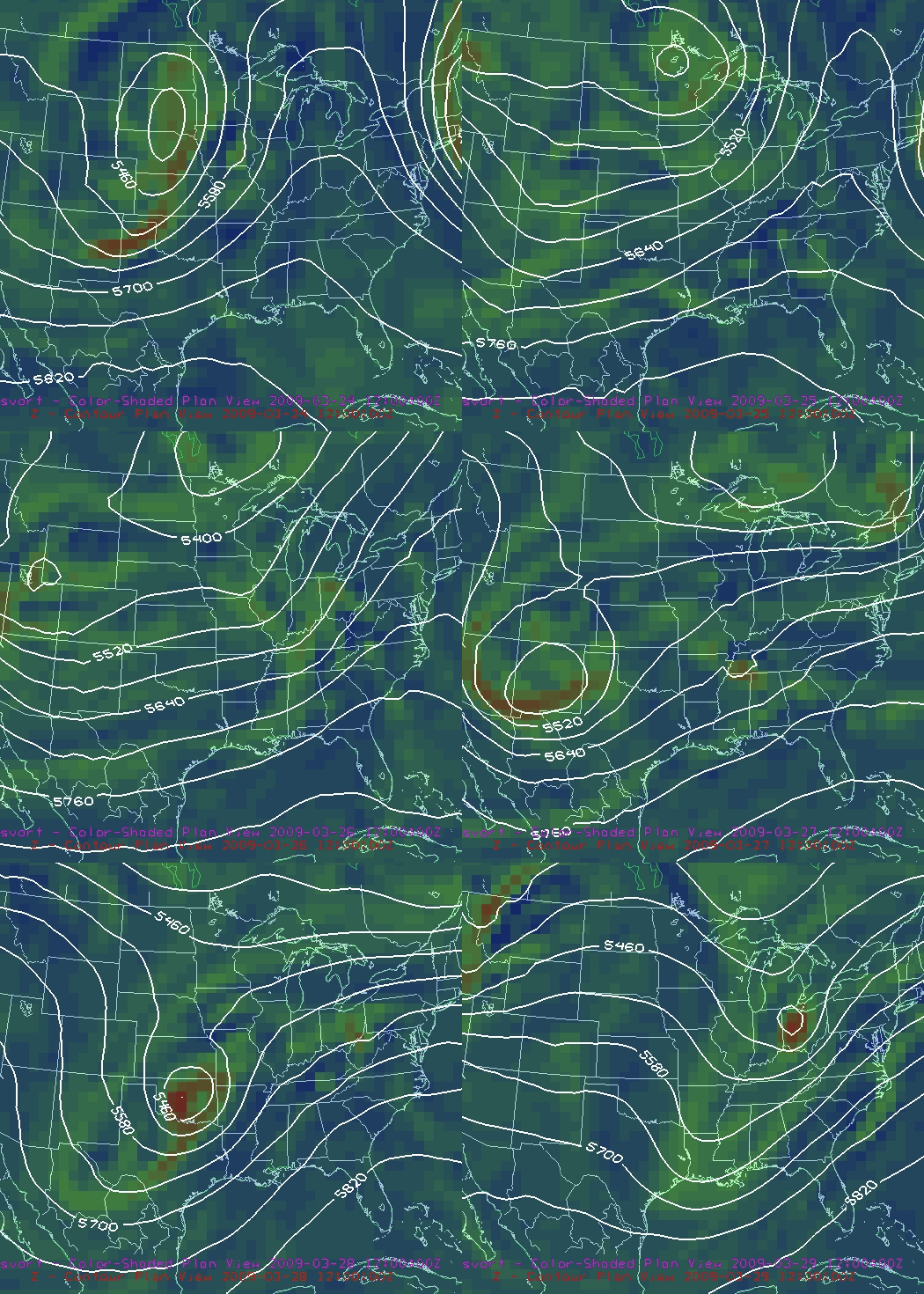
500 mb heights (contours) and vorticity (shading, upper-level disturbances are areas of vorticity), now through 6 am Sunday
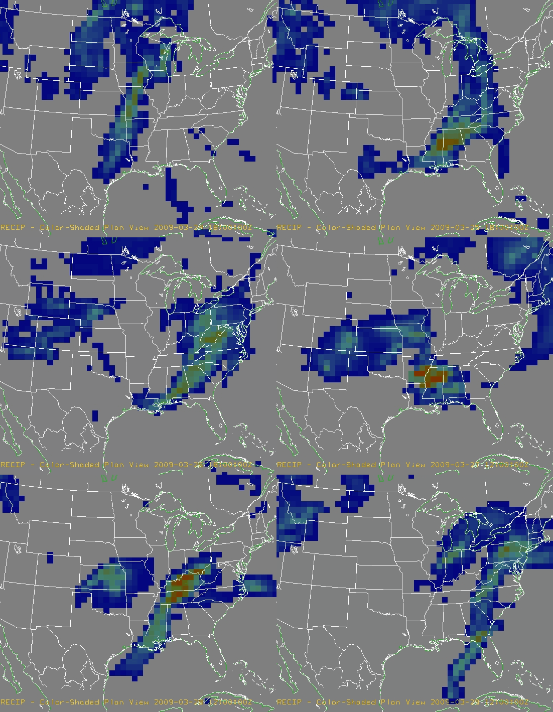
Precip in each 6-hour period from noon today through 6 am Sunday. Colors range from 0 to 2 inches. Notice the repeated rain events.
The new model runs are in, and are not too different from previous ones, except for those minor adjustments that can cause or stop a severe weather episode on Friday/Saturday. The computer models and the atmosphere are very complex, so a small error at hour 72 can become a much bigger error by hour 84. But, models have been consistent from run-to-run showing several heavy rain events over Alabama between tomorrow and Sunday, with over 6″ of rain possible in some locations. Severe weather is also possible, but that is more difficult to forecast now.
The first rain event will come tomorrow (Wednesday) during the day, as a cold front approaches and a weak upper-level disturbance moves through. Expect rainfall amounts near an inch.
The second rain event will come in tomorrow night and Thursday, as the front stalls over Alabama, and moist air flows up and over the slightly cooler air behind the front. Temperatures will be cold aloft, so thunderstorms are likely. The largest threat for severe weather will remain south of I-20 and west of I-65, but a couple of severe storms are possible in BHM. The big deal from BHM will probably be the heavy rain, with 2-3″ of rain between sunset tomorrow evening and lunchtime on Thursday. Flooding is possible.
The front will move back north on Friday, as a large upper-level storm dives into the SW US. This will bring additonal rain Friday morning, then a break in the rain late Friday and maybe into early Saturday, before a strong cold front moves through with one more round of heavy rain, and possibly severe weather, sometime Friday night or Saturday. It’s hard to tell about severe weather with this system, as it’s still 4 days away and the location of instability and shear is uncertain. But, it will likely bring us another inch or so of rain.
Total rainfall amounts between now and Sunday morning will likely be 4-6″ over much of Alabama, with some spots getting more. The ground is saturated from heavy rains over the winter, and some rivers are already higher than normal. It looks like the Army Corps of Engineers and Alabama Power are already preparing for this event, letting water out of the major lakes and rivers now, before the event. Bankhead Lake and Smith Lake have dropped 1 foot in the past 2 days, and drops are occurring at Weiss, etc. Still, if the rain events are as high as anticipated, flash flooding and river flooding are likely. If you live in flood-prone areas, keep an eye on the water levels starting tomorrow night and Thursday. Those with boats, etc., on lakes and rivers, make any necessary preparations for flooding before tomorrow if possible. I’m headed to the Warrior River later today to lift my 1973 Manatee high in the boathouse.



