


**No Weather Xtreme video today… have to get some serious voice rest today. No school programs, no talking this morning**
MORE ACTIVE WEATHER AHEAD: A very moist airmass remains over Alabama this morning, and while there is no real discernible trigger for widespread rain today, we certainly have to mention some risk of scattered showers and storms in this environment. The showers and storms today should be rather scattered, however, and most of them will come this afternoon.
Tomorrow seems to be the day with the best chance of strong to severe storms… here is the SPC Day 2 convective outlook below:
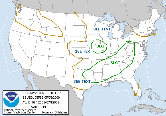
Would not be surprised for another MCS (mesoscale convective system) or even a derecho type system to move into Alabama during the day tomorrow with potential for damaging straight line winds. A few tornadoes are not out of the question where low level boundaries can focus low level convergence and enhance low level helicity. Looks like another day of watches and warnings for our state.
THURSDAY THROUGH THE WEEKEND: A very moist airmass will remain over Alabama during this four day period; nothing to bring in drier or cooler air. Dewpoints in the 60s; highs in the 80s. CAPE values will remain high, and no doubt we will need to maintain a chance of at least scattered showers and storms. Some of the global models try to bring in an upper ridge over the weekend, which would suggest a trend toward drier weather, and we have gone in that direction in the forecast. But, the GFS has not been particularly good in handling long range weather in recent weeks, and I would not be surprised if the southern edge of the westerlies will be close enough for a few thunderstorm areas to roll in here Saturday, and maybe even Sunday. So, no way we can promise a completely dry day through the weekend.
LONG RANGE: The GFS does try to bring an upper ridge in here by mid-month, with warmer and drier conditions likely if this is the correct solution…. see the output for May 20 below:

WEATHER BRAINS: Don’t forget you can listen to our weekly 30 minute netcast anytime on the web, or on iTunes. This is the show all about weather featuring many familiar voices, including our meteorologists here at ABC 33/40. You can even listen here on the blog; look for the player on the top left.
TWITTER: Don’t forget, you can follow our news and weather updates from ABC 33/40 on Twitter here. And, my personal Twitter feed is here if you want to keep up with my adventures in life. Twitter is a short messaging service you can receive via the web, cell phone, or IM.
We will keep the blog updated today, and I will have another forecast discussion by mid-afternoon… enjoy the day.



