…A SEVERE THUNDERSTORM WARNING REMAINS IN EFFECT UNTIL 430 PM CDT FOR NORTH CENTRAL TUSCALOOSA AND SOUTHEASTERN FAYETTE COUNTIES… At 414 PM CDT, a severe thunderstorm was located over Boley Springs, or 19 miles south of Carbon Hill, moving northeast at 55 mph.
HAZARD…60 mph wind gusts and quarter size hail.
SOURCE…Radar indicated.
IMPACT…Hail damage to vehicles is expected. Expect wind damage to roofs, siding, and trees. Locations impacted include… Berry and Boley Springs.
A Severe Thunderstorm Warning Remains In Effect Until 4:30 PM CDT For Northwestern Tuscaloosa And Southeastern Fayette Counties
Mar 14th @ 4:08 pm

…A SEVERE THUNDERSTORM WARNING REMAINS IN EFFECT UNTIL 430 PM CDT FOR NORTHWESTERN TUSCALOOSA AND SOUTHEASTERN FAYETTE COUNTIES… At 408 PM CDT, a severe thunderstorm was located near Berry, or 15 miles southeast of Fayette, moving northeast at 55 mph.
HAZARD…60 mph wind gusts and quarter size hail.
SOURCE…Radar indicated.
IMPACT…Hail damage to vehicles is expected. Expect wind damage to roofs, siding, and trees. Locations impacted include… Berry, Boley Springs and New Lexington.
A Severe Thunderstorm Warning Remains In Effect Until 4:30 PM CDT For Northwestern Tuscaloosa And Southern Fayette Counties
Mar 14th @ 3:58 pm

…A SEVERE THUNDERSTORM WARNING REMAINS IN EFFECT UNTIL 430 PM CDT FOR NORTHWESTERN TUSCALOOSA AND SOUTHERN FAYETTE COUNTIES… At 357 PM CDT, a severe thunderstorm was located 8 miles east of Ashcraft Corner, or 11 miles southeast of Fayette, moving northeast at 55 mph.
HAZARD…Golf ball size hail and 60 mph wind gusts.
SOURCE…Radar indicated.
IMPACT…People and animals outdoors will be injured. Expect hail damage to roofs, siding, windows, and vehicles. Expect wind damage to roofs, siding, and trees. Locations impacted include… Berry, Bankston, Boley Springs, Stone Wall, Moores Bridge, Fayette County Public Lake and New Lexington.
The Severe Thunderstorm Warning For Northeastern Pickens County Is Cancelled
Mar 14th @ 3:57 pm

…THE SEVERE THUNDERSTORM WARNING FOR NORTHEASTERN PICKENS COUNTY IS CANCELLED…
The severe thunderstorm which prompted the warning has moved out of the warned area. Therefore, the warning has been cancelled. A Tornado Watch remains in effect until 700 PM CDT for central and west central Alabama.
Severe Thunderstorm Warning Issued For Parts Of Fayette, Pickens, And Tuscaloosa Counties Until 4:30PM
Mar 14th @ 3:46 pm
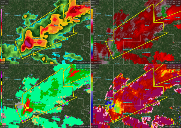

The National Weather Service in Birmingham has issued a
* Severe Thunderstorm Warning for…
Northwestern Tuscaloosa County in west central Alabama…
Northeastern Pickens County in west central Alabama…
Southeastern Fayette County in west central Alabama…
* Until 430 PM CDT.
* At 346 PM CDT, a severe thunderstorm was located over Ashcraft
Corner, or 11 miles east of Millport, moving northeast at 55 mph.
HAZARD…Ping pong ball size hail and 60 mph wind gusts.
SOURCE…Radar indicated.
IMPACT…People and animals outdoors will be injured. Expect hail damage to roofs, siding, windows, and vehicles. Expect wind damage to roofs, siding, and trees.
* Locations impacted include…
Fayette, Berry, Ashcraft Corner, Bankston, Boley Springs, Stone
Wall, Moores Bridge, Lubbub, Fayette County Public Lake and New
Lexington.