


…THE SEVERE THUNDERSTORM WARNING FOR NORTHEASTERN TUSCALOOSA COUNTY
WILL EXPIRE AT 730 PM CDT…
The storms which prompted the warning have moved out of the area.
Therefore, the warning will be allowed to expire.
A Tornado Watch remains in effect until 1100 PM CDT for central and
west central Alabama.
A Severe Thunderstorm Warning Remains In Effect Until 7:30 PM CDT For Northeastern Tuscaloosa County
Apr 18th @ 7:16 pm

…A SEVERE THUNDERSTORM WARNING REMAINS IN EFFECT UNTIL 730 PM CDT FOR NORTHEASTERN TUSCALOOSA COUNTY… At 715 PM CDT, severe thunderstorms were located along a line extending from near Boley Springs to near North Johns to near West Blocton, moving east at 40 mph.
HAZARD…60 mph wind gusts.
SOURCE…Radar indicated.
IMPACT…Expect damage to roofs, siding, and trees. Locations impacted include… Lake View, Vance, Abernant, Bankhead Lock And Dam, Tannehill Ironworks State Park, North Bibb, Whitson and Caffee Junction.
A Severe Thunderstorm Warning Remains In Effect Until 7:30 PM CDT For Eastern Tuscaloosa County
Apr 18th @ 7:05 pm

…A SEVERE THUNDERSTORM WARNING REMAINS IN EFFECT UNTIL 730 PM CDT FOR EASTERN TUSCALOOSA COUNTY… At 704 PM CDT, severe thunderstorms were located along a line extending from near Boley Springs to near Abernant to near Eoline, moving east at 50 mph.
HAZARD…60 mph wind gusts.
SOURCE…Radar indicated.
IMPACT…Expect damage to roofs, siding, and trees. Locations impacted include… Lake View, Brookwood, Vance, Abernant, Mercedes Benz Of Alabama, Bankhead Lock And Dam, Tannehill Ironworks State Park, North Bibb, Whitson, East Brookwood, Windham Springs, Wiley and Caffee Junction.
Severe Thunderstorm Warning Issued For Parts Of Tuscaloosa County Until 7:30PM
Apr 18th @ 6:46 pm
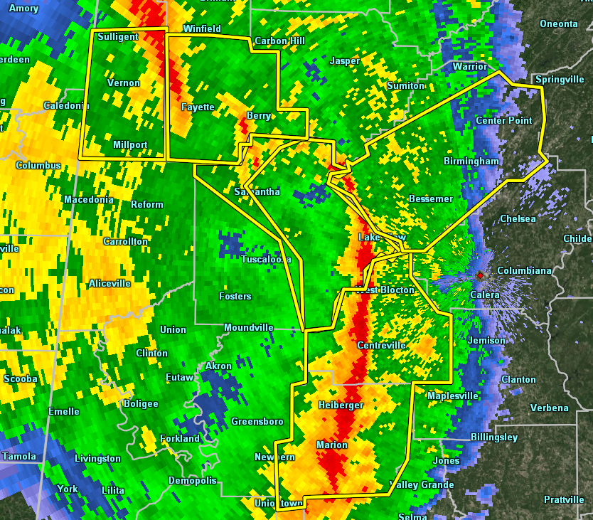

The National Weather Service in Birmingham has issued a
* Severe Thunderstorm Warning for…
Tuscaloosa County in west central Alabama…
* Until 730 PM CDT.
* At 646 PM CDT, severe thunderstorms were located along a line extending from 9 miles northwest of Samantha to Deerlick Creek
Campgrounds to near Low Gap, moving east at 50 mph.
HAZARD…70 mph wind gusts.
SOURCE…Radar indicated.
IMPACT…Expect considerable tree damage. Damage is likely to mobile homes, roofs, and outbuildings.
* Locations impacted include…
Eastern Tuscaloosa, Holt, Lake View, Brookwood, Coaling, Vance, Abernant, Samantha, Lake Wildwood, Deerlick Creek Campgrounds, Mercedes Benz Of Alabama, Bankhead Lock And Dam, Binion Creek
Landing, Tannehill Ironworks State Park, North Bibb, Whitson, Lake
Tuscaloosa, Cottondale, East Brookwood and Windham Springs.



