


[embedyt] https://www.youtube.com/watch?v=SKMFSU4_Sjc[/embedyt]
A cold front moved through Alabama on Saturday, but precipitation was limited to northern parts of the state. Temperatures were warm, with a breezy westerly wind. The upper trough that has been driving the front is moving into Alabama this morning, pushing the surface low east into southern Ohio. Clouds are wrapping around the low and will keep things cooler over the Tennessee Valley today. There could even be a few showers over the northeastern part of the state this afternoon. Highs today will range from the upper 50s to near 60F in Northeast Alabama to the upper 60s around Birmingham to the lower 70s over the rest of Central Alabama. Tonight will be chilly, with lows in the 40s across the area.
FOR YOUR MONDAY: Tomorrow will be partly cloudy and slightly cool, with a noticeable northerly breeze. We will start of fin the refreshing 40s, and highs will be in the upper 60s up north to lower 70s around Birmingham to upper 70s down south.
TUESDAY PERFECTION: Tuesday will be all about what spring is all about weather-wise in Alabama: a good supply of sunshine, warm afternoon readings between 73-82, and a nice southerly breeze. Dewpoints will be coming up and clouds will increase during the evening ahead of our next system.
TUESDAY NIGHT/EARLY WEDNESDAY STORMS: That will come in the form of a sharp upper trough over the Midwest that will push another front our way. That front will be knocking on the doorsteps of Northwest Alabama by sunrise Wednesday morning. By that time, showers and storms will already be pushing into the state. The pattern does not have a significant severe weather look as it arrives, but instability could ramp up on Wednesday and like this week, strong to severe storms could form Wednesday afternoon. We will be watching. Rainfall amounts will be decent, between one quarter and three quarters of an inch.
UPPER LOW: The Midwestern trough will cutoff into an upper low over the Ohio Valley, but it won’t have a big impact on us here in Alabama Thursday will featuring clearing skies, with developing stratocumulus behind in the cool sector behind the front. It will be breezy, with highs in the lower 70s mostly. Friday promises to be a beautiful day, with morning lows between 47-53 and afternoon highs rising well into the 70s.
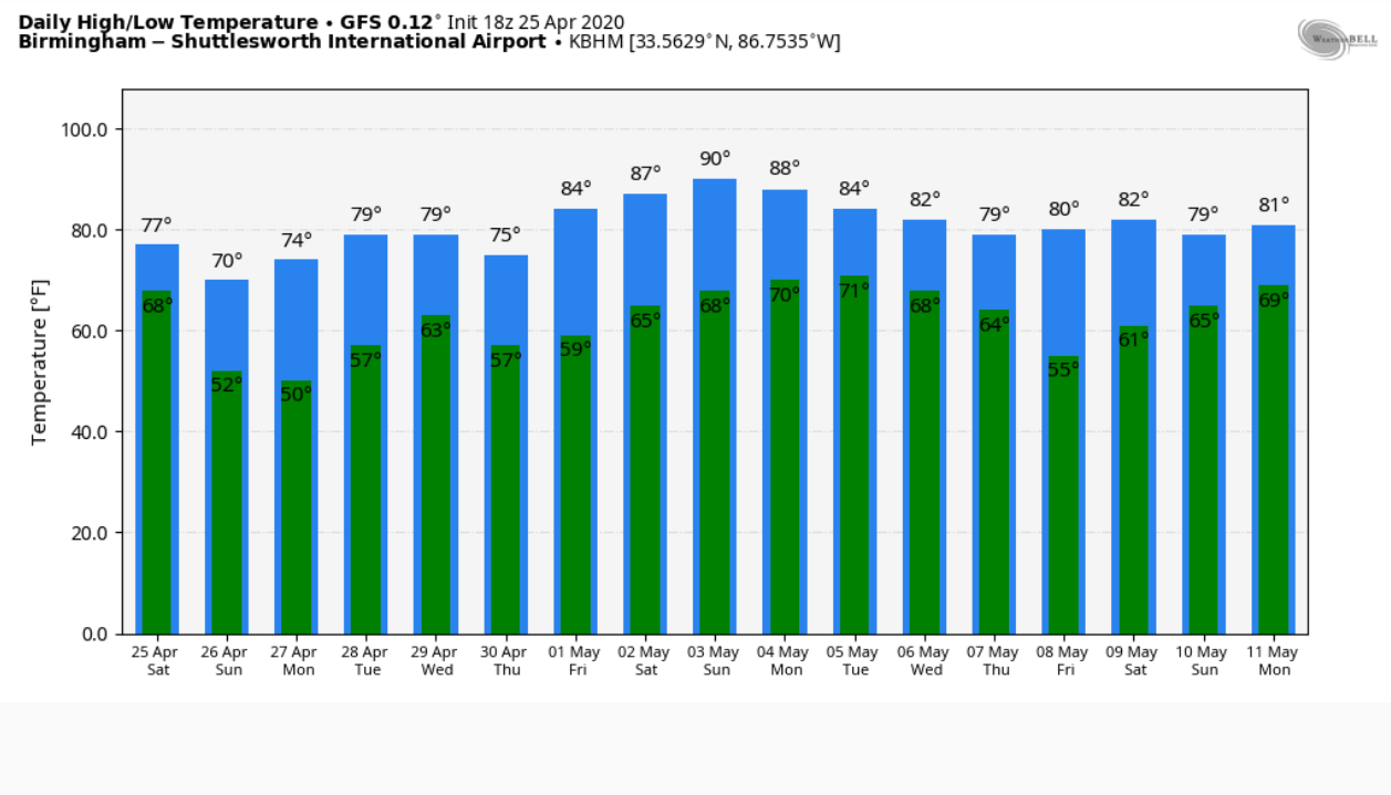
WEEKEND OUTLOOK: A warm look is setting up for next weekend, with dry conditions and partly cloudy skies. Highs will rise into the upper 70s and lower 80s. It could be even warmer, I think. Could there be a 90F in there somewhere? Just asking…
BEACHCAST: A little rain Wednesday night and Thursday, otherwise a beautiful week at the beach. Highs around 80F. lows in the upper 50s and 60s. Water temperatures are in the lower 70s.
Click here to see the Beach Forecast Center page.
NATIONALLY: Excessive heat warnings today in the Phoenix area in Arizona as the mercury pushes 100-107F. A variety of excessive heat watches and warnings and heat advisories cover parts of Nevada, Arizona, and Southern California.
ADVERTISE WITH US: Deliver your message to a highly engaged audience by advertising on the AlabamaWX.com website. The site enjoyed 17.2 MILLION pageviews in the past 12 months. Don’t miss out! We can customize a creative, flexible, and affordable package that will suit your organization’s needs. Contact me, Bill Murray, at (205) 687-0782, and let’s talk.
WEATHERBRAINS: This week’s show will focus on the May 3, 1999 tornado outbreak that hit Oklahoma. Check out the show at www.WeatherBrains.com. You can also subscribe on iTunes. You can watch the show live at live.bigbrainsmedia.com or on James’ YouTube Channel You will be able to see the show on the James Spann 24×7 weather channel on cable or directly over the air on the dot 2 feed.
ON THIS DATE IN 2006: Severe Cyclone Monica spared the Darwin area as it curved into land early along the North Coast of Australia, making landfall in a sparsely populated area. At the time of landfall, the cyclone had an estimated central pressure of 879 millibars. If this estimate is correct, it would make Monica the strongest tropical cyclone ever in the southern hemisphere. Of course, reconnaissance aircraft are only used in the Atlantic, so we will never know for sure. Typhoon Tip (1970) is the strongest typhoon ever observed on earth. Follow my weather history tweets on Twitter. I am @wxhistorian at Twitter.com.



