


Saturday was a beautiful, warm early May day across Alabama. Highs were in the 80s, including 82F at Anniston, 83F at Birmingham, and 84F at Tuscaloosa. It was 86F in Montgomery. 87F was the warmest across the state, registered at Tuskegee. Today will be warm again, with afternoon readings ranging from 81F over Northeast Alabama to 87F around Montgomery.
FOR YOUR SUNDAY: High pressure is centered near Orlando this morning. Temperatures are starting off in the 50x across the area, under partly cloudy skies. Today will be warm, as well as Monday and Tuesday, before a gradual cool-down commences Tuesday. Let’s dig into the forecast details.
FRONTAL SYSTEM: A front will drop into North Alabama Monday morning. Storms that develop along the front this afternoon across southern Tennessee will diminish before drifting down into Alabama tonight, but don’t rule out a storm over the Northeast overnight. And redevelopment could occur Monday, and any storms that do manage to develop could be strong given decent instability and lapse rates, but plenty of factors are against severe weather, so don’t expect much. Monday will be warm again, with highs well into the 80s.
FOR TUESDAY: An upper-level disturbance sliding through the Midwest will spin up surface low pressure along the front just to our north. A cold front will push through Alabama on Tuesday, producing showers and storms. There will be moderate instability, decent lapse rates, and fairly weak shear, so widespread severe weather is not expected, but there will be a few strong to severe storms Tuesday afternoon or evening.
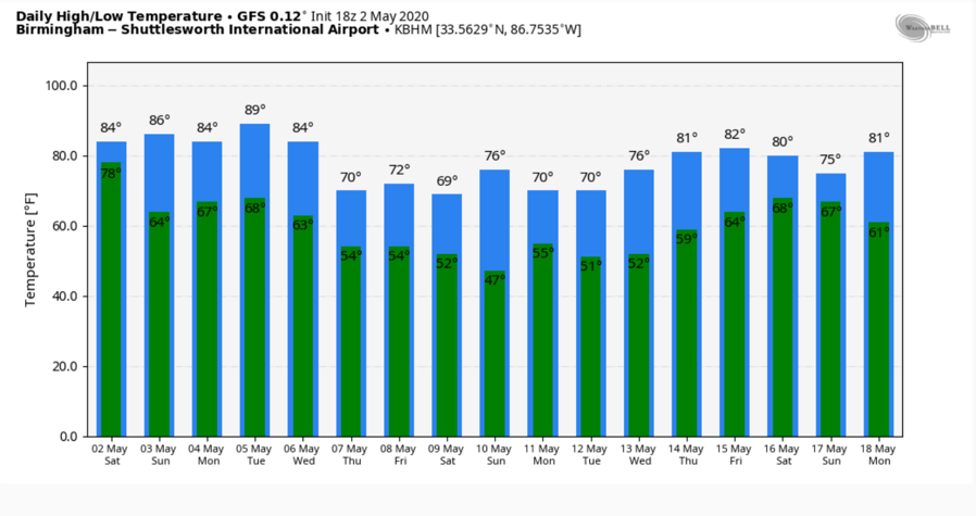
COOLER TREND: Cooler conditions will follow for Wednesday, with highs in the 70s. By Thursday morning, readings will be in the 40s across much of the area. Expect middle 70s Thursday, and lower to middle 70s on Friday.
MORE RAIN AND STORMS: Ran and storms will enter the picture again Friday night into Saturday as a northwest flow system pushes across Alabama and the South.
VOODOO TERRITORY: Look for another storm system around the 16th and 17th (Saturday and Sunday).
BEACHCAST: A beautiful week is in store along the beautiful beaches of Alabama and Northwest Florida. Skies will be partly cloudy, with highs in the 80s and lows in the 60s. Water temperatures are running around 70F.
Click here to see the Beach Forecast Center page.
WEATHERBRAINS: This week, the panel will entertain Deke Arndt from NCEIE. Check out the show at www.WeatherBrains.com. You can also subscribe on iTunes. You can watch the show live at live.bigbrainsmedia.com or on James’ YouTube Channel You will be able to see the show on the James Spann 24×7 weather channel on cable or directly over the air on the dot 2 feed.
ON THIS DATE IN 2009: It was a stormy day across Alabama. Early that morning, a powerful bow echo was located over eastern Texas. This complex of severe thunderstorms would be classified as a derecho or widespread damaging wind event. It would race eastward at over 60 mph, making the 700 miles to western Georgia in less than 12 hours. Thousands of trees were blown down due to straight-line winds across parts of Hale, Marengo, Choctaw, Perry, Hale, and Chilton counties. In addition, thunderstorms formed during the early afternoon along a boundary that was oriented across Central Alabama.
After the event, survey teams from the National Weather Service in Birmingham were able to identify six tornado tracks across the state. EF1 tornado damage was found near Wolf Creek, which is west of Pell City in St. Clair County, near Dunavant, which is in Shelby County south of Leeds and east of Mount Laurel/Shoal Creek, in the community of Sunshine, in Hale County south of Greensboro, near Moody and Bald Rock in St. Clair County.
An EF0 tornado was identified in the Brook Highland development, just off U.S. 280, and over to the Greystone Legacy Golf Course. Fortunately, no injuries were reported in Alabama, but one woman was killed when a tree fell on her mobile home near Laurel, Mississippi. Follow my weather history tweets on Twitter. I am @wxhistorian at Twitter.com.



