ON THE WEATHER MAPS THIS MORNING: A huge upper-level ridge of high pressure covers the western United States with an amplifying trough over the eastern U.S. A developing low-pressure system to the east of us pulled drier air down into Alabama behind a weak frontal system on the backside of the low. At the surface, pressures are low east of the Rockies. Out in the Atlantic, the Bermuda High is a little east of its normal position, allowing Josephine to turn to the northwest.
FOR YOUR SUNDAY: We’re starting off in the upper 60s to lower 70s this morning under fair skies this morning. A second cold front is pushing towards Alabama and it will move through this afternoon. It will still encounter enough moisture to trigger a few isolated showers and storms during the afternoon and evening hours.
MONDAY/TUESDAY: Dewpoint will drop behind this front and the much drier air will effectively put an end to almost any showers for storms for Monday or Tuesday. Lows both mornings will fall into the middle and upper 60s over the northern half of the state. Highs will be near 90F.
WEDNESDAY THROUGH FRIDAY: A fairly typical summertime pattern will return with scattered afternoon and evening showers and storms. Highs will be around 90F each day, lows will be in the middle 60s into the weekend.
WEEKEND OUTLOOK: More of the same into the weekend, with scattered showers and storms each day. Highs will be near 90F. Lows will be near 70F.
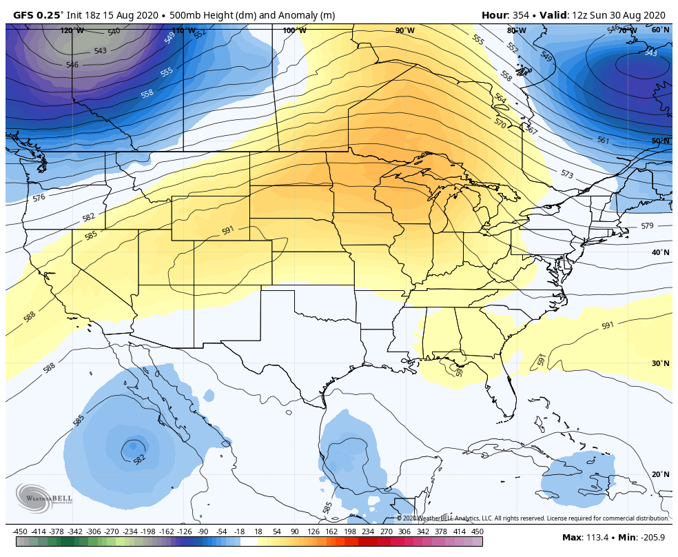
VOODOOLAND: A ridge of high pressure builds back in week two, and that may play a role in steering a tropical system across the Gulf toward Texas.
JOSEPHINE: Tropical Storm Josephine has been holding its own despite fairly strong wind shear, but the shear is starting to take its toll. The system is barely a tropical storm early this morning, and it will likely weaken to a tropical depression by tonight as the wind shear values are expected to increase. In fact, Josephine could weaken into an open tropical wave by Monday. Josephine is still expected to pass far enough to the north of the northern Leeward Islands this morning so that any impacts will be minimal, at most.
Once we get past the early part of the week, we may need to keep an eye on Josephine once again for regeneration and strengthening. The environmental conditions may become more favorable with lower wind shear values possible. Also, Josephine will be turning more to the northeast by then & will start heading in the same direction as the wind shear. This will lead to a net low shear, favorable environment. Some of the model guidance are showing intensification into a tropical storm again with tropical storm impacts on Bermuda possible around Thursday. This is something that will be watched closely & interests on the island of Bermuda should keep an eye on Josephine.
KYLE: Tropical Storm Kyle started losing tropical characteristics yesterday and it will become post-tropical this morning. The system is accelerating eastward over the open Atlantic well south of the Canadian Maritimes this morning.
NEXT SYSTEMS TO WATCH: If you’ve hung out around here for very long, you probably know that we keep an eye on old frontal systems that drop into the Gulf of Mexico. Of course, that is the case this week, and with the warm waters of the Gulf, it will be a place to watch this week. The models aren’t picking up on any development at this time though. And over Africa, a strong tropical disturbance is about to move into the eastern Atlantic. Some of the modeling is giving an increasing chance that this system will be able to develop into a tropical storm over the Caribbean and it will bear watching.
BEACHCAST: A gorgeous week weather-wise is ahead along the beautiful beaches of Alabama and Northwest Florida. A good supply of sunshine each day with just a chance of a shower or storm. Highs will be in the lower 90s. Lows will be in the upper 70s. Water temperatures are running in the middle 80s. The surf will be 1-2 feet all week with a low rip current risk.
Click here to see the Beach Forecast Center page.
NATIONALLY: The heat is the storm nationally, especially over the western United States. Numerous heat advisories and excessive heat warnings are in effect today, blanketing virtually all of the western states like Washington, Oregon, California, Arizona, Nevada, Utah, and Idaho into western Montana.
DANCING WITH THE STATS: The heat index at Imperial, CA reached 122F yesterday! The combination of dewpoints in the upper 70s from a surge of moisture from the Gulf of California and temperatures over 100F.
ADVERTISE WITH US: Deliver your message to a highly engaged audience by advertising on the AlabamaWX.com website. The site enjoyed 17.2 MILLION page views in the past 12 months. Don’t miss out! We can customize a creative, flexible, and affordable package that will suit your organization’s needs. Contact me, Bill Murray, at (205) 687-0782, and let’s talk.
WEATHERBRAINS: This week, the panel will undertake a busy agenda, being joined by friends of the podcast Todd Lericos and Alan Gerard from the National Weather Association and NWA Foundation. Then we will speak with Greg Schoor, the NWS Severe Weather Program Director. Check out the show at www.WeatherBrains.com. You can also subscribe on iTunes. You can watch the show live at live.bigbrainsmedia.com or on James’ YouTube Channel You will be able to see the show on the James Spann 24×7 weather channel on cable or directly over the air on the dot 2 feed.
ON THIS DATE IN 2007: The mercury at the Birmingham Airport reached 103F, marking the 10th consecutive day with highs of 100F or hotter. The streak would end the next day, but the ten-day run of 100F+ temperatures stands as the longest in the city’s history. Follow my weather history tweets on Twitter. I am @wxhistorian at Twitter.com.