


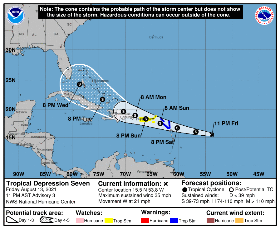
SUMMARY OF 10:00 PM CDT INFORMATION
LOCATION…15.5N 53.8W
ABOUT 540 MI…870 KM E OF THE LEEWARD ISLANDS
MAXIMUM SUSTAINED WINDS…35 MPH…55 KM/H
PRESENT MOVEMENT…W OR 280 DEGREES AT 21 MPH…33 KM/H
MINIMUM CENTRAL PRESSURE…1010 MB…29.83 INCHES
WATCHES AND WARNINGS
A Tropical Storm Warning is in effect for…
* Antigua and Barbuda, Anguilla, St. Kitts and Nevis, and Montserrat
* Saba and Sint Eustatius
* Sint Maarten
* St. Martin and St. Barthelemy
A Tropical Storm Watch is in effect for…
* British Virgin Islands
* U.S. Virgin Islands
* Puerto Rico, including Vieques and Culebra
FORECAST DISCUSSION
While Tropical Depression Seven has maintained an irregularly shaped cirrus canopy of deep cold cloud tops near its estimated center, the convection does not appear well organized. Several SSMIS microwave passes between 2011 UTC and 2205 UTC did not reveal much organization under the cirrus, with just a few patches of deeper convection contributing to the larger stratiform region. A helpful ASCAT-B pass at 0030 UTC showed that the center was near the southeastern end of this cirrus canopy, and found peak winds lower than earlier today at only 27 kt. The 0000 UTC subjective Dvorak estimates were T2.5/35 kt from SAB and T2.5/30 kt from TAFB and the most recent objective ADT estimate was in between at T2.2/32 kt. A blend of these data support keeping the initial intensity at 30-kt for this advisory.
The small cyclone continues to move quickly off to the west at 280/18 kt. A large low- to mid-level ridge draped across the central and western North Atlantic is expected to maintain the system on a general west-northwest heading, though with gradual deceleration as the ridge is eroded some by a mid- to upper-tropospheric trough. The latest track guidance remains tightly clustered, but a bit more poleward through the first 72 hours. Afterwards, more track guidance spread becomes apparent. A quick look at the latest ECMWF ensemble guidance suggest that some of this spread is driven by the forecast intensity of the system, with stronger members taking the cyclone on a more poleward track. For now, the latest NHC track forecast is fairly close to, but a little poleward of, the previous track. This track remains close to the HCCA and TVCN consensus aids, and roughly splits the difference between the deterministic GFS and ECMWF model solutions.
The intensity forecast is somewhat conflicting. Even though both the GFS & ECMWF based SHIPS guidance depict low 200-850 hPa vertical wind shear between 5-10 knots over the next 48 hours, the depression is also embedded in very dry mid-level air, with 700-500 hPa layer mean relative humidity as low as 44 percent currently in the ECMWF-SHIPS. In addition, the system is moving rapidly westward, and a continued fast motion in the short-term may result in higher westerly mid-level shear, which may have a larger than normal effect to a small tropical cyclone in a very dry environment. After 48 hours, vertical wind shear out of the northwest is expected to increase, ahead of a large upper-level trough digging southwestward, upstream of the cyclone. Moreover, land interaction with both Puerto Rico and Hispaniola remains a distinct possibility, especially if the cyclone tracks left of the current forecast track. It is worth noting the latest HWRF run continues to be an extreme outlier with a much higher intensity than the remaining guidance. In fact, much of global model guidance and COAMPS-TC regional hurricane model barely maintains a closed circulation over the next 36-48 hours. I have elected to maintain a very similar forecast to the previous advisory, with peak winds of only 45 kt in 48-60 hours. This forecast remains conservative and is still lower than the SHIPS and HCCA intensity guidance.
KEY MESSAGES
1. Tropical storm conditions are expected in portions of the Leeward Islands late Saturday or early Sunday, and are possible over the Virgin Islands and Puerto Rico on Sunday. The risk of strong winds will then spread westward to the Dominican Republic Sunday night and Monday.
2. Heavy rainfall could lead to flash and urban flooding over the Leeward and Virgin Islands. Across Puerto Rico, heavy rainfall may lead to flash, urban and small stream flooding, along with the potential for mudslides.
3. There is a risk of wind and rainfall impacts across Haiti, the Turks and Caicos Islands, the southeastern Bahamas, and Cuba next week, and interests in those areas should monitor the progress of this system.



