


IDA FAST FACTS
5:00 AM CST Sun Nov 8
Location: 20.8°N 85.7°W or 85 SSW of western tip of Cuba
Or 600 miles SSE of Mobile
Max sustained: 90 mph
Moving: NW at 12 mph
Min pressure: 983 mb
HIGHLIGHTS
…Ida is expected to approach the northern Gulf Coast Monday night and Tuesday
…Expected to become extratropical and weaken
…Still will bring tropical storm force winds, coastal flooding to SE Louisiana, coastal Mississippi, Alabama, NW Florida
…Will give us heavy rain and 15-30 mph winds Monday night and Tuesday in Central Alabama
THE LATEST
Ida did indeed become a hurricane overnight.
This morning, the hurricane is approaching the Yucatan Peninsula with top winds of 90 mph. It is moving northwest at 12 mph.
It is still expected to grow a little stronger and should have top winds of 100 mph later this morning.
It will accelerate northward. By 11 p.m. tonight, it will be just 400 miles south of Mobile moving north at 15 mph.
It will have begun to weaken a bit by then, but tropical storm force wind will extend 150-175 north of the center.
By 6 a.m. Monday, it will be 300 miles south of Mobile. It still will likely be a hurricane then.
Tropical storm force winds will reach the mouth of the Mississippi River by 3 p.m. Monday and could reach the Alabama coast by 5 p.m.
Water levels will rise along the Gulf coast, reaching 1-3 feet in southern parishes of Louisiana around Houma, 3-6 feet in southeastern parishes like Plaquemines and St. Bernard and 1-3 feet along the Mississippi, Alabama and Florida coasts as far east as Panama City. This will come from an increasing easterly flow that will pile water up along the coast.
By 6 p.m. Monday, it will be 150 miles south of Mobile. It will have weakened to a tropical or post tropical storm by then. It is expected to then start turning eastward, never reaching the coast. But as it does, it still will spread tropical storm force winds from Southeast Louisiana through the Mississippi, Alabama and Northwest Florida coasts as far east as Panama City.
The official forecast takes it to within 50 miles of Destin then curves it sharply back out to sea over the Gulf.
Now…all this is a forecast. Here is the official track with the typical forecast error area shown in white.
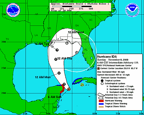
Don’t be surprised if Ida remains tropical right up to landfall though. But the effecrs are going to be the same along the coast and inland.
Our impacts are unchanged here in central Alabama…
…clouds increasing tonight…becoming cloudy tomorrow
…increasing easterly winds of Monday…averaging 10-20 mph and becoming gusty
…rain arriving as early as Monday afternoon
…3 to 4 inches of rain Monday night into Tuesday morning…windy with easterly winds 15-30 mph.
…Still windy on Tuesday with sustained winds 15-25 mph.
…Thunderstorms not expected here



