


The above shows the predicted precipitation (liquid equivalent) in the 24 hours ending at 6 pm Saturday. At BHM, it’s about 0.1″, and with a 10:1 snow to water ratio, that would mean 1″ of snow. Notice that the higher precip amounts are farther south, and the blue line is the rough rain/snow line. So, if this model is even half right, someone in central Alabama could see a little snow Friday night or Saturday.
An upper-level disturbance will move through Alabama this weekend, and may even form a weak surface low pressure area in the Gulf. However, most models keep this low, and significant Gulf moisture, southeast of BHM. The NAM model only indicates snow flurries, the Canadian GEM shows plenty of rain (and maybe a little snow on the northern edge) in south Alabama, and the NOGAPS and European models show nothing. Bottom line…we don’t know. Most likely, a dusting is the most we would see in BHM. If I had to pick a location in Alabama to get 1″ of snow (chance only 30%), I’d go with Montgomery.
The thing is, two factors cause upward motion and precip…upper-level disturbances (vorticity moving in, associated with upper divergence), and warm air moving in. We’ll have the vorticity, but the cold air will be coming in also, and will likely offset some of the upward motion and limit snow potential.


This is still 3 days away, and things can change. But, right now the best guess is for nothing more than a dusting, if that.
It is going to get cold, though. Temps will start falling this afternoon, stay in the 40s tomorrow, and then in the 30s most of the day on Friday and Saturday. Here is the GFS model temperature forecast for the BHM airport:
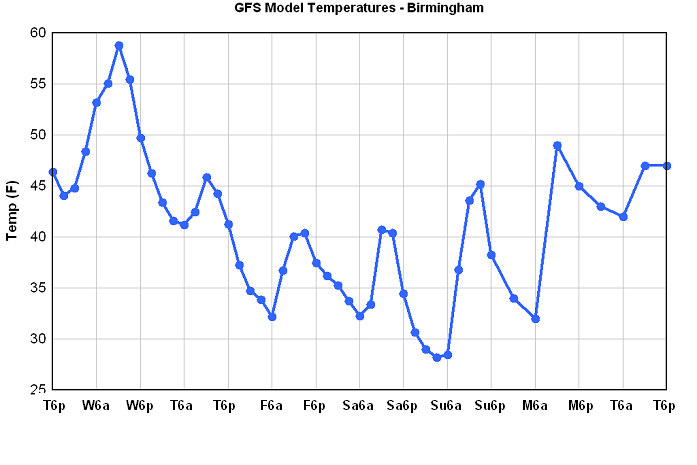
Notice that once it falls below 50 this evening, it may not get back there for 4 or 5 days.



