


A significant and high impact severe weather event is anticipated this afternoon and tonight across much of the deep south, including Alabama. This morning, the SPC upgraded west Alabama to a level 4/5 moderate risk of severe weather. They also expanded the level 3/5 enhanced risk to include the Tuscaloosa and Birmingham metros, and the level 2/5 slight risk to include the rest of the state with the exception of extreme SE Alabama. With that being said, we don’t want people to get to hung up in the exact risk categories, and to know that the entire state has a significant risk of severe weather this afternoon and tonight.

Models have trended towards less morning and afternoon convection, and focused more on an organized line of severe storms overnight tonight. This means that there will be more time for the atmosphere to destabilize, and when combined with the strong dynamics in play, a very favorable severe weather environment is expected. The main timing looks to be from about 11pm-6am from west to east. The main show will be the squall line, but anything that forms out ahead of it possibly as early as 3pm this afternoon across west Alabama will need to be watched closely for potential severe weather. The above image is of the HRRR model valid at 11pm CT. You will notice the main squall line, as well as several semi discrete cells ahead of it. Both the squall line and any discrete cells will have a significant potential to be severe.
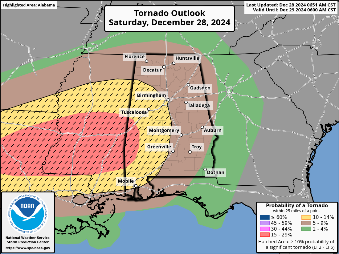
Todays storms will feature a significant risk for all severe hazards, including damaging winds, tornadoes, and large hail. The highest probability of tornadoes, as well as some that could be strong to violent, will be over west Alabama within the hatched area in the above graphic from the SPC. They mention that some tornadoes could be intense, reaching or exceeding EF3 intensity. In addition, there is a risk of potentially widespread wind damage, with gusts reaching hurricane force in a few areas particularly west of I65. We anticipate fairly widespread tree and powerline damage, and recommend treating severe thunderstorm warnings like a tornado warning tonight and seeking shelter.

We encourage you to review your severe weather safety plans now, prior to the severe weather arriving. Be sure you are close to a good source of weather information, and have at least 3 ways to get warnings. This could include broadcast media (TV), weather radios, and enabling WEA alerts on your cell phones. Be sure that you identify your severe weather shelter areas ahead of time, and move to them if warnings are issued for your area. Because this event will be primarily an overnight event, it is even more important to have reliable ways to get warnings, so we strongly recommend that everyone has a weather radio. It will wake you up in the event warnings are issued for your area.



