


An all new edition of the ABC 33/40 Weather Xtreme video is available in the player below. You can subscribe to the Weather Xtreme video on iTunes by clicking here.
As always prior to a major weather event, I encourage you to watch the Weather Xtreme video, which features all of the graphics that go along with this discussion. Sometimes those images tend to do a better job of explaining the situation; a picture is worth a thousand words, you know.
EYES TO THE WEST: Needless to say, we will be watching developments to the west very closely today as severe weather parameters come together over Arkansas, Louisiana, and Mississippi later today and tonight. SPC has defined a moderate risk of severe weather for this region, and it will pretty much give us a preview of what we can expect in Alabama tomorrow. Today here will be dry, warm, and breezy with a high in the low to mid 80s. A few showers or storms could creep across the state line late tonight, mainly after midnight.
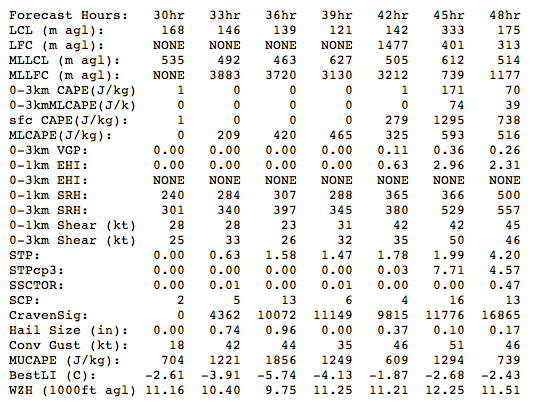
TOMORROW: Showers should break out early tomorrow morning, perhaps in the pre-dawn hours, ahead of a warm front moving northward through Alabama, This will bring dewpoints in the mid 60s up in here, and setting up a volatile situation as a very dynamic system approaches. Aside from somewhat marginal instability values, everything else will be in place for a classic spring severe weather outbreak… high helicity (veering of the wind within the lowest 3 km of the atmosphere), strong wind fields at the surface and aloft, low LCLs (lifting condensation level), diffluence aloft, and steep lapse rates. SPC has defined a moderate risk of severe weather for much of Alabama and Mississippi. For the true weather geeks, here are some severe weather parameters from the NAM tomorrow afternoon. This is from last night’s 00Z run, so the last column (48 hours) is valid at 7:00 p.m. local time tomorrow.
TIMING: We believe now the main window for severe storms will be from around 12:00 noon until 12:00 midnight. A few severe storms could form along the warm front tomorrow morning in West Alabama, but the most significant storms will come during the afternoon and nighttime hours.
WHAT TO EXPECT: Storms that form across our state during that 12 hour window could produce large hail, damaging wind, and a few tornadoes. With the severe weather parameters we are seeing, a few violent, long track tornadoes will be possible. Initially, the storms will be cellular during the afternoon and evening hours… this is the greatest tornado threat; then toward midnight we will deal with a squall line that will have potential for damaging winds.
HOW MUCH RAIN: Some flooding issues are not out of the question; the latest QPF from HPC shows 3 to 4 inches of rain over Northwest Alabama, with amounts around 2 inches for Tuscaloosa, Birmingham, Anniston, and Gadsden. The NWS in Memphis has already issued a flash flood watch for their CWA (county warning area). The ground, of course, is not saturated, thank goodness. In fact, we have had measurable rain on only two days so far this month in Birmingham.
TALLADEGA: It will be very difficult to get the Aaron’s 312 in tomorrow due to the rain and storms, but the weather will be fine for Sunday’s Aaron’s 499 with a partly sunny sky and a high around 80. Needless to say, there is great concern with a potential severe weather event of this magnitude ahead and the thousands of campers in place on the grounds around the Talladega Superspeedway. Everybody that is camping will need to be very aware of severe weather watches and warnings tomorrow, and have a plan of action in place in the event tornado warnings are issued for northern Talladega County. ABC 33/40 has a transmitter on Bald Rock Mountain, and provides the strongest TV signal over the track, so be sure and watch us as the day wears on for the latest severe weather information. Be sure and follow instructions from officials at the Superspeedway.
CALL TO ACTION: Today could be a good time to review your severe weather plan. If you live in a mobile home, you will need to have a shelter available tomorrow and tomorrow night, and a way to get there. In site built homes, be sure you have your “safe place” identified, and let all of the kids know where it is. And, of course, you have to be in a position to hear severe weather warnings. Never rely on sirens; they reach a limited of people that are outdoors. Every home, business, and church needs a NOAA Weather Radio receiver; you can buy those now at all Publix and Handy TV locations for under 30 dollars. And, you can sign up for WeatherCall to receive warnings by home phone or cell phone here.
SUNDAY AND NEXT WEEK: The sky becomes partly sunny Sunday with a high around 80, and Monday for now looks dry. The 00Z GFS does bring a strong disturbance through that could squeeze out a shower or two on Tuesday, but it doesn’t look like a big rain event. Some hint showers or storms could return the following weekend (May 1-2); see the Weather Xtreme video for details.
FOLLOW ALONG: Here are our weather team Twitter accounts….
| James Spann | Jason Simpson | Ashley Brand |
| J. B. Elliott | Bill Murray | Brian Peters |
| Dr. Tim Coleman | WeatherBrains Podcast | E-Warn (AL wx watches/warnings) |
WEATHER BRAINS: Don’t forget you can listen to our weekly 30 minute netcast anytime on the web, or on iTunes. This is the show all about weather featuring many familiar voices, including our meteorologists here at ABC 33/40. You can even listen here on the blog; look for the player on the top left.
LIVE CHAT: We are now offering a real time chat here on the blog… open blog comments will stay in place, of course, but this will allow a more immediate method of communication for weather geeks. We do have moderators posted over there, so be sure and play nice. Members of our weather team will be there from time to time to answer questions; we will post those times we are available here on the blog.
I will be at Shades Mountain Baptist Church this morning doing a weather program for a home school group… look for the next Weather Xtreme video here by 3:30 this afternoon. And, of course, we will keep the blog updated for fresh information today and throughout the event. Stay tuned.



