


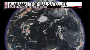
We’re already keeping a close eye on the first tropical wave of the 2025 Atlantic Hurricane Season, and it could be the start of something big. Currently labeled Invest #97L, this system is located off the west coast of Africa, slowly moving westward into the eastern Atlantic. The conditions are right for development, with early signs suggesting that this system could become our first hurricane of the season. There’s even a possibility that it could strengthen into a major hurricane. However, it’s still early, and there’s a lot we don’t know yet.
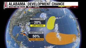
For now, there’s no immediate threat to the U.S. coastline, but this one is certainly worth watching closely as it continues to track westward. If it does develop into a tropical storm or hurricane, the next name on the list is Erin.
CURRENT CONDITIONS AND POTENTIAL DEVELOPMENT
Right now, 97L is located just off the Cabo Verde Islands, moving steadily toward the west. Satellite imagery shows a mid-level circulation, and while there’s some Saharan dry air over the eastern Atlantic that could stunt its development, there is still enough potential for it to evolve into a tropical depression in the next 24-48 hours.
This tropical wave is expected to move into a more favorable environment this week and will likley become a tropical storm and hurricane.
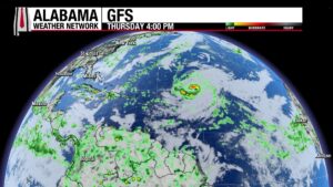
By Thursday it will be about 600 miles northeast of the northern Lesser Antilles. This will be a crucial turning point. As it approaches the western side of the Azores Bermuda high, we may see the system start to recurve out to sea—or continue westward toward the Caribbean, Bahamas, or even the East Coast of the United States.
Here is a look at the potential steering pattern by Thursday:
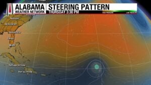
For now, it’s too early to make any definitive predictions, but this is the general track we’ll be watching.
POTENTIAL SCENARIOS FOR 97L/ERIN
Based on early synoptic guidance, we’re looking at two main potential paths for 97L:
Path 1: The high pressure over the Eastern U.S. and North Atlantic weakens, allowing 97L to recurve out to sea. In this scenario, 97L would pass well north of the U.S., potentially avoiding direct impacts but still affecting Bermuda. The risk of significant land impacts is low if the system recurs before getting too close to the East Coast.
Path 2: If the high-pressure systems (especially the North Atlantic one) remain strong, 97L will likely continue its westward track, putting it on course toward the North Caribbean, the Bahamas, or possibly even the U.S. East Coast. This is a more concerning scenario if the system remains westward and doesn’t recurve as expected.
WHAT WE KNOW (AND WHAT WE DON’T)
While the models are still uncertain, we know that 97L will likely strengthen into a tropical storm, potentially becoming a hurricane. The development of the system is dependent on several factors, including its interaction with the high-pressure systems, the location of the jet stream, and the moisture available in the atmosphere. If it struggles to organize, it may be steered westward by the trade winds, which could bring it closer to land.
There’s also the possibility that if 97L remains weaker or more disorganized, it could track farther west, bringing it into the Bahamas or even the U.S. East Coast. But again, this is all speculative at this point.
TIME TO WATCH, NOT TO WORRY
The next 5-7 days are critical for 97L as it moves across the Atlantic. The data we’re seeing will continue to evolve, and we’ll have a much clearer picture as we approach midweek. For now, though, it’s important to keep an eye on the system without jumping to conclusions. Worrying about its potential impacts specifically at this stage is premature. We’ll all be watching this one closely, and as the storm’s path becomes clearer, we’ll provide more updates.
NOT ERIN’S FIRST RODEO
There was a significant hurricane in 1995 that made landfall near Vero Beach on the East Coast of Florida on August 1st, crossed the Peninsula, emerged into the Gulf, and made landfall near Pensacola on August 2nd as a category two hurricane with top winds of 100 mph and a central pressure of 973 mb.


