Daily Weather Briefing
Sunday, October 4, 2026
ALABAMA THIS MORNING
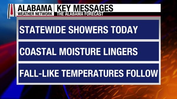
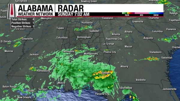
A large swath of showers spreads across south-central and south Alabama this morning, while a smaller thunderstorm impacts Cullman and surrounding areas. Skies are cloudy, and temperatures are in the low to mid 70s statewide, with the northwesternmost portion of the state still in the upper 60s.
ALABAMA 7 DAY FORECAST
A stalled frontal boundary bisecting the state and Gulf moisture being advected from the south will cause today to be a rainy day statewide. Rainfall totals will differ, with south Alabama expecting to see the highest amounts. Cooler, drier air moves in behind the front tomorrow, diminishing rain chances everywhere but the south, which could see a few lingering showers. The state will trend drier throughout the week, and although highs won’t be in the pleasant fall 70s, they will provide some relief compared to the low 90s we experienced last week.
RAINY SUNDAY – Oct 4
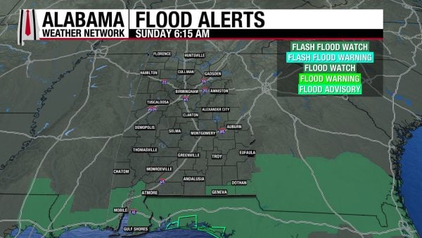
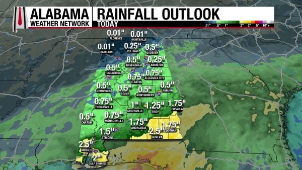
A rainy Sunday is ahead for Alabama, with rain in full swing already in the south. This rain will spread northward throughout the day, with scattered to widespread showers and thunderstorms occurring statewide. Rainfall totals today will range from less than a quarter of an inch in the northwest, to half an inch to an inch and a half of from north-central to south Alabama, to 2 to 2.5 inches near the coast and in the southeast. Where those higher amounts of rain are expected, the National Weather Service has issued Flood Watches until midnight tonight. Clouds and rain will keep highs limited to the upper 70s over most of the state, with the low 80s still possible in the northwest and on the coast.
RAIN ENDS SLOWLY BEGINNING THE WEEK – Oct 5-6
No rain is expected across the northern two-thirds of the state as we head into the week, as the dry air behind the front will already be present in the region. Low rain chances stick around for the south, as how far the front gets remains in question. Highs statewide on Monday will mostly be in the low 80s, but a mid-80-degree reading or two is possible, especially in west-central Alabama. Highs on Tuesday will range from the upper 70s east to low to mid 80s west. As mentioned above, they’re not those crisp fall temperatures, but they’re better than the 90s!
DRY THROUGH FRIDAY – Oct 7-9
Rain chances will be little to none Wednesday through Friday as the front pushes into the Gulf and the entire state is privy to the dry air that follows it. Lows will begin to drop into the 50s, with the mid 50s expected statewide each morning. Wednesday’s highs will range from the mid 70s south to upper 70s to low 80s north. The upper 70s will linger in the south Thursday while the northern two-thirds of the state reach the low to mid 80s. North Alabama may even see the high 80s. By Friday, the 80s will dominate, spanning from the low 80s south to the low to mid 80s centrally, and the central to upper 80s north.
RAIN POSSIBLE AGAIN NEXT WEEKEND – Oct 10
Rain chances increase somewhat by Saturday, and the upper 70s to low 80s dominate Alabama.
RAINFALL OUTLOOK
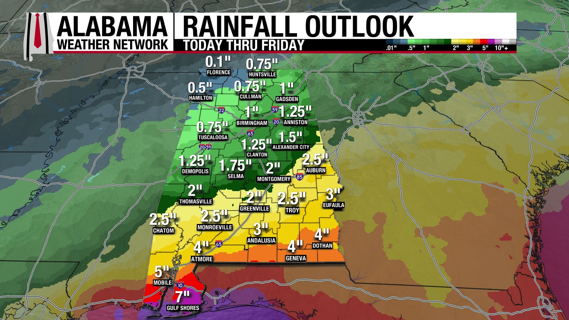
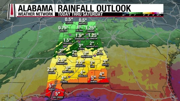
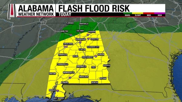
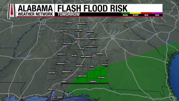
Rainfall amounts over the next week range from half an inch to around 2 inches in the northern half of the state and 2 to 5 inches in the southern half of the state. The majority of this rain will fall today, as can be seen in the rainfall total graphic for today above; hence, the Weather Prediction Center has placed most of Alabama under a Slight Risk (2/4) for Flash Flooding today, with the north under a Marginal (1/4) Risk. Flash flooding is possible as showers and storms will be efficient rainfall producers, with urban, low-lying, and poorly drained areas most susceptible to flooding. Tomorrow, a Marginal Risk exists for southeast Alabama. Remember, if you see a flooded roadway: Turn Around, Don’t Drown!
THE ATLANTIC
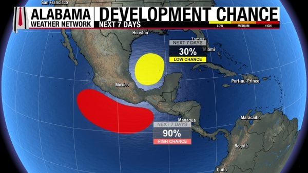
The National Hurricane Center is watching a broad area of low pressure in the southwestern Gulf for potential tropical development. It has a 30% chance of development, but it will be a few days before that occurs, if it occurs at all. It is just something to keep an eye on for now.
THE PACIFIC
Hurricane Rachel, a Category 2 storm with sustained winds of 100 mph and a central pressure of 968 mb, will begin to slowly weaken tomorrow as it moves westward. It is expected to become a tropical storm by Thursday. Large swells impact west-central Mexico and the Baja California Peninsula through Monday.
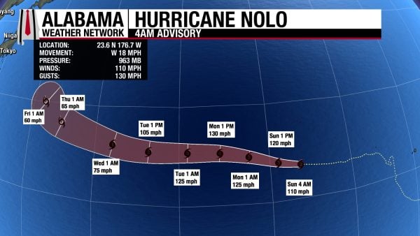
Hurricane Nolo is far past Hawaii as a Category 2 storm with sustained winds of 110 mph and a central pressure of 963 mb. It is expected to continue to move westward and intensify until it abruptly weakens Thursday. It will pass the International Dateline on Sunday.
The area of low pressure off the southern Mexican coast has a 90% chance of tropical development over the next seven days, with development expected toward the middle or latter half of this week.
RAINY START TO THE WEEK ON THE BEACH
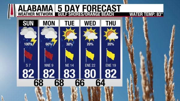
Today and tomorrow will be better spent inside on Alabama’s Gulf Coast as rain chances are high, especially today. Showers and thunderstorms are ongoing on the coast and into south Alabama, and they will continue throughout the day. The high is in the low 80s, skies are cloudy, and winds blow from the south at 5 to 10 mph. The rip current risk is High due to that southerly flow, nd the surf height is 3 to 4 feet. Rain chances decrease to 60% tomorrow, with a few more breaks in the rain possible. The latter half of the week will be more pleasant for beachgoing.

WEATHERBRAINS 1081
Tomorrow’s WeatherBrains episode’s scope will be fire weather. From a historical and modern perspective, Tom Hultquist, Dr. Stephanie Hoekstra, and Robyn Heffernan talk fire. Listen to the episode wherever you get your podcasts or watch it here!
TODAY IN WEATHER HISTORY
October 4, 1995 – Opal’s Wild Swing
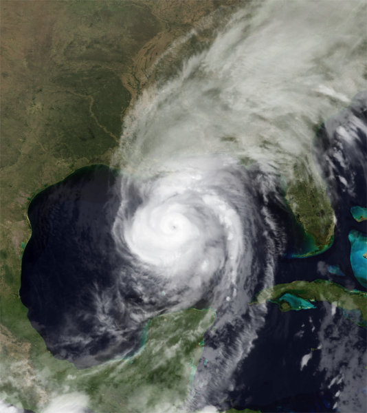
For forecasters and residents along the northern Gulf Coast, Hurricane Opal became a frightening lesson in just how quickly a hurricane could change. On the evening of October 3, 1995, Opal was a Category 2 hurricane over the Gulf of Mexico with winds near 100 mph. By the following morning, it was undergoing rapid intensification, a dramatic increase in a hurricane’s wind speed over a short period, while accelerating toward the Florida Panhandle. Thousands who had expected a Category 2 hurricane suddenly faced the possibility of something far more dangerous, and late evacuations produced gridlock on highways leading away from the coast.
The numbers coming back from Air Force reconnaissance were extraordinary. Opal’s central pressure plunged to 916 millibars, and maximum sustained winds reached an estimated 150 mph, making it a powerful Category 4 hurricane just shy of Category 5 intensity. At the time, the 916-millibar pressure made Opal the most intense Atlantic hurricane ever observed during October. The extraordinary strengthening occurred while the hurricane was still hundreds of miles south-southwest of Pensacola.
Part of the explanation was beneath the storm. Opal crossed an unusually deep pool of very warm Gulf water, providing an abundant supply of ocean heat at a time when atmospheric conditions were also favorable for strengthening. Because the warm water extended well below the surface, Opal could churn the Gulf without quickly bringing colder water upward. Changes within the hurricane’s compact inner core also contributed to the explosive strengthening.
Just as remarkably, Opal then weakened almost as rapidly as it had strengthened. Its small inner eyewall collapsed as a larger outer eyewall became dominant, while the hurricane encountered less favorable conditions approaching the coast. By landfall near Pensacola Beach around 5 p.m., Opal had weakened to a Category 3 hurricane with maximum sustained winds near 115 mph and a central pressure of 942 millibars. Hurlburt Field near Mary Esther measured sustained winds near 84 mph and a peak gust of 144 mph, although that extreme gust has been considered questionable.
The weakening winds did not spare the coastline. Opal had already generated an enormous ocean response while it was a Category 4 hurricane offshore. Storm surge reached 15 feet from the Navarre Beach area eastward toward Destin, while tremendous breaking waves pushed water and debris even farther inland. Nearly 300 homes were destroyed, another 1,000 suffered major damage, and portions of Highway 399 and U.S. Highway 98 were washed away. The devastation demonstrated that the ocean does not immediately respond when a hurricane’s wind speed begins to fall.
Opal raced northward through Alabama, bringing destructive winds, falling trees, power outages, heavy rain, and tornadoes. Nine short-lived tornadoes were documented across six Alabama counties, mostly near and east of the storm’s track. About 2.6 million people in Alabama lost electricity, some for more than a week, and two people were killed in Gadsden when a massive oak tree fell onto their mobile home. Nine direct deaths occurred in the mainland United States, and total damage approached $3 billion. Opal became a lasting lesson in how quickly hurricane intensity can change.
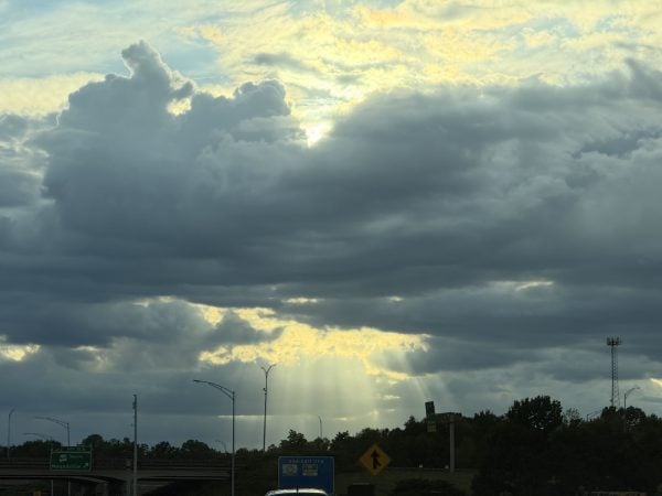
IMAGE OF THE DAY
Skywatcher Vanessa Sanchez took this picture of the sun shining through the clouds after a shower in Tuscaloosa yesterday evening.