


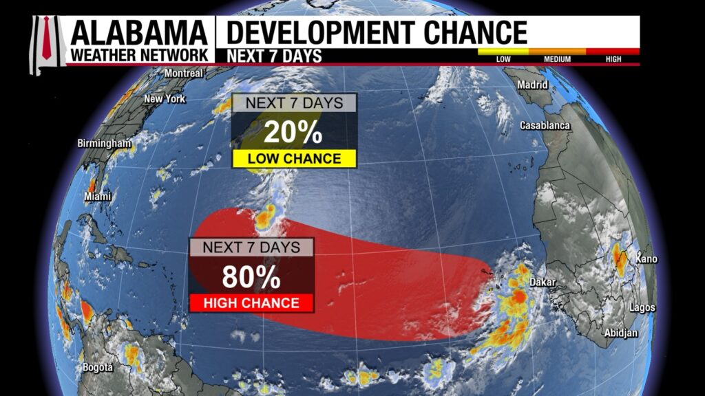
As we settle into another summer weekend, Sunday brings a mix of hazy summertime weather with a wary eye beginning to turn ot the tropics, which may be awakening from their slumber. The combination of a tropical wave moving over the northern Gulf of Mexico and moisture building over the region will set the stage for increasing rain chances, especially as we head into Sunday night and Monday. Today will be mostly dry, while rain chances will be picking up tomorrow. The rain is likely to stay in the isolated to scattered category through the morning on Monday, expect thunderstorms to develop as the day progresses, with localized heavy rainfall in some areas. Make sure to have your rain gear ready if you’re heading outdoors! And watch out for lightning.
SUNDAY FORECAST: WARM AND HUMID
Sunday will be a day of partly cloudy and seasonably warm conditions with summerlike humidities. Expect high temperatures to range from the mid to upper 80s in many places, with some locations pushing into the low 90s. Winds will remain light, coming from the east at 5-10 mph. As we move into Sunday night, expect rain chances to taper off slightly, but the humid conditions will remain, with overnight lows in the low 70s.
MONDAY THROUGH FRIDAY: RAINY WEEK AHEAD
As we move into the start of the workweek, expect more of the same weather patterns. Moisture will continue to stream into the region, keeping rain chances elevated throughout the week. Monday will bring a mix of sunshine and showers, with scattered thunderstorms developing as the day progresses. Highs will hover around 90°F, with heat index values pushing into the low 100s in some areas. Rain chances remain high Tuesday and Wednesday, with the potential for heavy downpours, especially in the afternoon. By Thursday and Friday, a gradual decrease in rain chances is expected, but expect continued humidity and temperatures near 90°F.
VOODOO TERRITORY: EARLY INDICATIONS OF DRYING OUT
Looking further into the future, we might start to see some relief by the end of next week, with drier air possibly filtering in. However, this is still several days away, so expect fluctuating rain chances over the next week. It’s important to stay tuned for any updates as we head into the second half of the month.
SEVERE WEATHER OUTLOOK: MARGINAL RISK IN THE SOUTHERN ROCKIES
The Storm Prediction Center has issued a Marginal Risk for severe thunderstorms from the Southern Rockies to the Central Great Plains. Isolated strong storms could develop in the region, with potential for damaging winds and hail. Fortunately, this threat does not extend to Alabama, but it’s something to watch for those traveling westward.
TROPICAL WEATHER OUTLOOK: SYSTEMS TO WATCH
There are a couple of areas to monitor in the Atlantic as we move into the second week of August. The tropical wave near the west coast of Africa is showing signs of potential development, with a 50% chance of becoming a tropical depression or storm by the middle to latter part of next week. This system is expected to move west-northwestward, and although it’s too early to pinpoint its exact path, it’s something to keep an eye on. Closer to home, the system in the Central Atlantic remains disorganized, with a low chance of development in the next 48 hours. We’ll continue to monitor these systems as they evolve.
ERIN: IS DAT YOU?
There was a Hurricane Erin in 1995. It struck Pensacola as a Category 2 hurricane with top winds of 100 mph. It caused damage across southern Alabama as it was on a west-northwest track after having crossed the Florida Peninsula two days before.
BEACH FORECAST: RIP CURRENT RISK REMAINS MODERATE
The beautiful beaches of Alabama and Northwest Florida will see mostly sunny skies on Sunday, with some afternoon thunderstorms likely. Surf heights will range from 1 to 3 feet, and the rip current risk will be Moderate for most of the region, so swimmers should remain cautious. Water temperatures are in the mid-80s, perfect for a dip, but keep an eye on the weather if you’re planning to be near the water. Winds will be light, coming from the east at 10-15 mph.
WEATHERBRAINS GUEST: CARLY ANNA & STORM CHASER COACHING SITE
This week on WeatherBrains, we’re joined by Carly Anna, Gabriel Harbor, and Trey Greenwood to talk about their brand-new storm chasing coaching platform. Tune in at 7:00 PM CDT on Monday as we dive into how the platform works, the inspiration behind it, and how it’s setting new standards for storm chaser education, safety, and success. You can watch live on YouTube at weatherbrains.com or listen on all major podcast platforms.
WEATHER HISTORY: ISLE DERNIERE HURRICANE OF 1856
The Isle Derniere, a small resort off the Louisiana coast, was devastated by a hurricane on August 10, 1856. The island, located about 110 miles southwest of New Orleans, was only 22 miles long and less than one mile wide. It had 20 cottages and a hotel, Muggah’s Hotel, where many prominent Louisiana families vacationed. The hurricane’s winds and storm surge caused 140 fatalities as the storm pounded the island and survivors sought refuge on the ship The Star, which barely escaped disaster. Today, the island is submerged, with only pelicans and birds remaining.



