


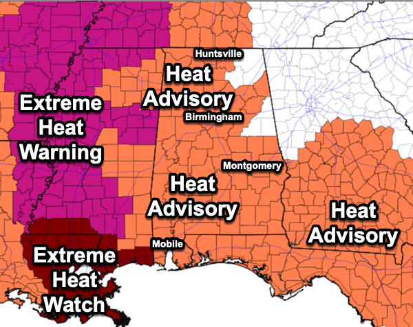
Hot temperatures, high humidity, and random afternoon and evening storms, it looks and feels a lot like late July in Alabama. High across Alabama today are in the mid to upper 90s and with dew points in the mid-70s, we are seeing those heat index values in the 100°-109° range. Nearly all of Alabama, 61 of our 67 counties are included in a Heat Advisory again today. We live in Deep South, we know how to stay cool, but when you have such a high heat index values, the onset of heat illness is much quicker this time of year.
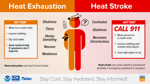
Heat is the leading weather-related cause of death in the U.S., claiming hundreds of lives each year. It can worsen existing health issues and lead to serious illness. While everyone is at risk, certain groups are especially vulnerable, including:
• Young children and infants, whose bodies don’t regulate heat as well
• Older adults, especially those with health conditions, limited mobility, or who live alone
• People with chronic medical conditions
• Pregnant women, due to risks like preterm birth and low birth weight
It’s crucial to check on those at higher risk—especially if they lack air conditioning.
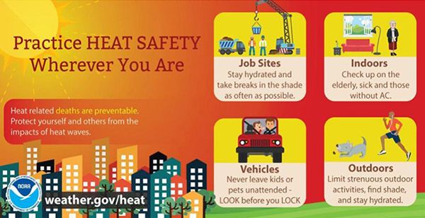
Vehicle safety warning: Never leave children, pets, or disabled individuals in a parked car, even briefly. In 2024, 39 children died from being left in hot cars—these tragedies can happen in just 10 minutes, even in cooler months.
Rain chances today and tomorrow are in the 20-40% range. Any summer storm will produce tremendous amounts of lightning, which tends to be the biggest threat this time of year. With such a moisture-rich air mass in place, any storm will be a prolific rain producer, which can lead to areas of isolated flash flooding. The forecast for tomorrow will be a near carbon copy of today.
BIRMINGHAM ALMANAC: For July 22nd, the average high for Birmingham is 91° and the average low is 73°. The record high is 100° set in 1993, while the record low is 55° set in 1947. We average 0.18” of precipitation on this date and the record value is 2.92” set in 2006.
USA BRIEF: Oppressive heat to expand across the Central Plains, Midwest, and Deep South through mid-week; Nearly 60 million people under heat-related warnings, watches, & advisories. Thunderstorms to pose a flash flood threat in portions of the Southwest, Midwest, and Southeast. Severe storms are likely in the Northern Plains & Midwest; Unseasonably cool & comfortable conditions in the Northeast & Southwest.
END OF WEEK AND BEYOND: Highs will slide back down into the upper 80s and low 90s to end the week and for the weekend, rain chances will increase to the 40-60% range. It will stay very humid and the overall weather pattern just won’t change next week as we continue through the Dog Days of Summer. The upper-ridge will begin to strengthen some next week, and we are likely going to see highs back in the mid-90s, and likely more heat advisories. We see no big ticket weather item showing up the next 7-10 days for Alabama. The only thing this time of year that typically will cause significant changes in our weather is a tropical system and we seeing nothing like that in the forecast any time soon.

IN THE TROPICS: Invest 94L we were watching in the Central Tropical Atlantic has dissipated and is no longer a concern. The rest of the Atlantic Basin is quiet, including the Gulf and Caribbean.
WORLD TEMPERATURE EXTREMES: Over the last 24 hours, the highest observation outside the U.S. was 120.9F at Basrah International Airport, Iraq. The lowest observation was -100.5F at Vostok, Antarctica.
CONTIGUOUS TEMPERATURE EXTREMES: Over the last 24 hours, the highest observation was 115F at Stovepipe Wells, CA. The lowest observation was 34F at Bryce Canyon, UT; Mount Washington, NH; and Saranac Lake, NY.



