


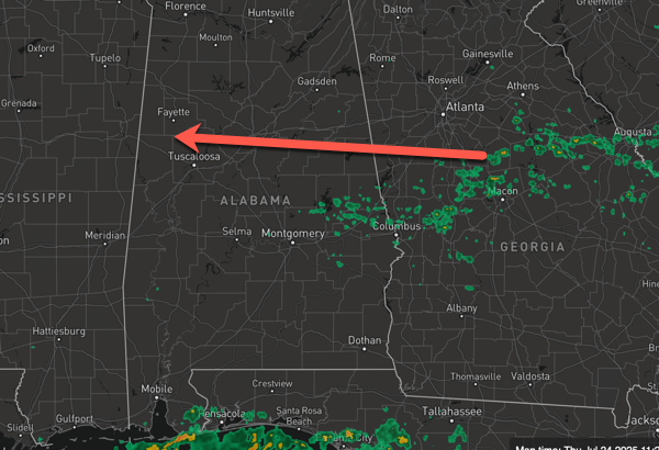
CLASSIC, SUMMER WEATHER: Today and tomorrow expect highs ranging from the upper 80s to lower 90s across Alabama, which are right at average for this time of year. Rain chances are in the 30-40% range for the northern half of the state, but are higher over the southern half of the state and along the Gulf Coast. Rain and storms today, like most days, are random in nature, and fairly scattered with most locations remaining dry. However, as we all know, summer storms produce tremendous amounts of lightning and intense tropical downpours, which can lead to areas of isolated flash flooding. Like yesterday, rain and storms will be moving from east to west across Alabama this afternoon and evening.
BIRMINGHAM ALMANAC: For July 24th, the average high for Birmingham is 91° and the average low is 73°. The record high is 104° set in 1952, while the record low is 62° set in 1966. We average 0.17” of precipitation on this date and the record value is 3.64” set in 2017.
USA BRIEF: Approximately 130 million people are under Extreme Heat Warnings & Heat Advisories from the Central Plains to the Northeast. Heavy rain, flash flooding, and severe weather likely from the Central Plains and Midwest to the Great Lakes. Heavy rain possible along much of the Gulf coast over the next few days. Relatively tranquil weather expected across the West, but a fire weather threat for northern California into the Great Basin due to lightning.
VERY HOT END TO JULY: Over the weekend, rain chance fall below 20% range and highs will return to low 90s on Saturday, with mid 90s forecast Sunday. For next week, the upper-ridge will begin to strengthen some and we are going to see highs back in the mid-90s and upper 90s…likely the hottest week of weather so far this year. I would not be surprised to see some low 100s on the maps several days next week.
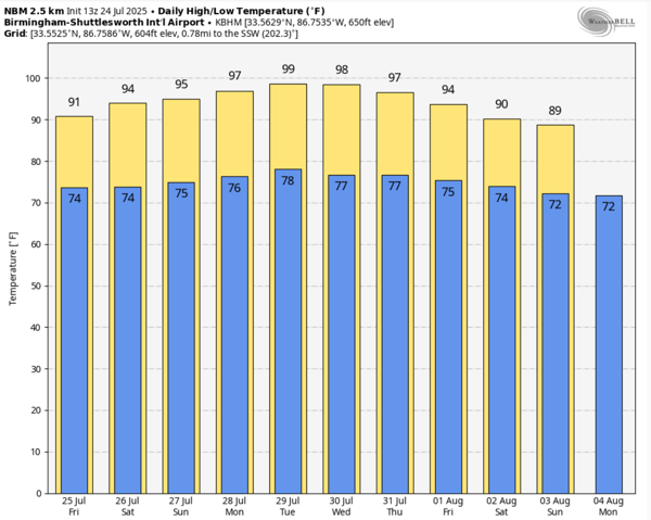
Plan on more heat advisories being issued likely as early a Sunday and continuing for several days next week, as heat index values will soar into the danger range (greater than 105° for the northern two-thirds of the state, greater than 108° for the southern sections of the state). I would not be surprised to see some Extreme Heat Warnings issued for portions of Alabama as well. These are issued when the heat index is likely to exceed 110°, and this is not entirely out of the question at times next week.
As far as rain chances, for the first half of the week rain chances are expected to remain less than 20%, however, by the end of the week, the ridge will begin to weaken and slide to the west. This will allow for rain chances to increases while afternoon highs are expected to decrease to the lower 90s.

IN THE TROPICS: A trough of low pressure over the north-central Gulf is currently producing a broad area of disorganized showers and thunderstorms. Over the next day or two, this system is forecast to move generally westward across the north-central portion of the Gulf where some slow development is possible. By this weekend, the system is likely to move inland, ending its chances for development. Regardless of tropical cyclone formation, locally heavy rainfall is possible for portions of the northern Gulf coast through this weekend. Formation chance through 7 days…low…10 percent. The rest of the Atlantic Basin is quiet for now.
WORLD TEMPERATURE EXTREMES: Over the last 24 hours, the highest observation outside the U.S. was 123.3F at Omidieh, Iran. The lowest observation was -103.0F at Vostok, Antarctica.
CONTIGUOUS TEMPERATURE EXTREMES: Over the last 24 hours, the highest observation was 109F at Death Valley, CA. The lowest observation was 28F at Peter Sinks, UT.



