


As we roll into the first Sunday of August, a midsummer cold front has carved its way into the Deep South, bringing with it a much-needed break from the recent oppressive heat. But the cooler temperatures come at a price—unsettled weather continues across much of Alabama, Georgia, and the Florida Panhandle. Wedge flow, deep tropical moisture, and a persistent upper trough all conspire to keep clouds, showers, and storms in the forecast through the remainder of the weekend and well into next week.
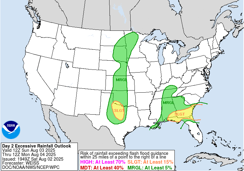
HEAVY RAIN THREAT HOLDS OVER EAST ALABAMA
A complex and dynamic pattern is setting up early this morning across the state, with cold air damming (CAD) continuing to push westward into eastern Alabama. Deep tropical moisture is pooled along this boundary, with precipitable water values between 2.1 and 2.4 inches and persistent west-southwesterly flow aloft overriding the easterly wedge at the surface. The result: efficient rainfall processes with hourly rates of 1.5 to 2 inches possible. A Flood Watch remains in effect for much of eastern and southeastern Central Alabama through 7 AM, but localized flash flooding may remain a concern into the daylight hours. Shortwave energy rotating through the mean trough will help sustain development along and east of I-59.
SUNDAY WILL FEEL LIKE LATE SEPTEMBER IN SPOTS
Thanks to widespread cloud cover, wedge flow, and rainfall, highs today will be unseasonably cool—especially across East Alabama and into West Georgia. Many locations near the AL/GA border may stay in the mid 70s all day. Even Birmingham may not reach 80. The cooler air is most noticeable east of I-65, while areas west toward Tuscaloosa could still sneak into the mid 80s. With dewpoints holding in the low 70s, it won’t feel crisp—but it certainly won’t feel like early August either.
THE WEEK AHEAD STAYS WET AND COOL
The frontal boundary will linger just offshore or over the southern tier of the state into early next week, continuing to serve as a focus for daily showers and thunderstorms. A broad upper trough over the eastern U.S. remains intact, and shortwaves rotating through it will keep rain chances elevated each afternoon and evening. Through Wednesday, rainfall totals could range from 0.5 to 1 inch across the northwest counties to 2 to 3 inches along and southeast of the I-85 corridor. Highs Monday and Tuesday will remain below average, generally in the 70s to low 80s east and mid 80s west.
HEATING UP AGAIN BY NEXT WEEKEND
By Thursday and Friday, the upper trough begins to lift out and upper heights start to build back in from the west. This will gradually suppress widespread rain chances and allow temperatures to climb back into the mid to upper 80s. The following weekend looks warmer and more settled, with typical summer scattered storms returning, but no major systems expected.
VOODOO TERRITORY: HOT RIDGE MAY EXPAND AGAIN
Peeking into week two, ensemble guidance shows the potential for the Desert Southwest ridge to build eastward again, bringing hotter and drier conditions back to the region by mid-August. If this trend holds, we could see temperatures pushing back toward 90 and lower rain chances across Alabama by the middle of the month.
SEVERE WEATHER OUTLOOK
From the SPC: A Marginal Risk (Level 1 of 5) for severe thunderstorms exists today across parts of the southern and central High Plains and eastern Oregon. No organized severe weather is expected in Alabama today, but isolated storms with gusty winds or brief heavy rain will continue, especially in southeast Alabama where instability remains higher.
TROPICAL WEATHER OUTLOOK
The National Hurricane Center is monitoring two areas: a non-tropical low off the North Carolina coast has a low (30%) chance of acquiring subtropical or tropical characteristics before moving away from the coast Monday. Farther east, a tropical wave is expected to emerge off the African coast soon, with a 20% chance of development over the next 7 days. Nothing currently poses a threat to the Gulf.
BEACH FORECAST FOR THE BEAUTIFUL BEACHES OF ALABAMA AND NORTHWEST FLORIDA
It will be an unsettled beach day from Dauphin Island to Destin with widespread showers and thunderstorms likely. Highs will reach around 90, with water temperatures in the upper 80s to near 90. Rip current risks are low along the Alabama coast, but moderate to high across parts of the Florida Panhandle—especially near State Park beaches in Franklin County. Surf heights remain around 1 to 2 feet. UV index is extreme, so don’t forget the sunscreen between storms.
WEATHERBRAINS PREVIEW
On Monday evening at 7 PM CDT, join us for WeatherBrains Episode 1020 live on YouTube at youtube.com/weatherbrains. Our guest will be Evan Fryberger, who humorously bills himself as “the world’s worst YouTube weatherman.” We’ll dive into his style of delivering calm, thoughtful weather commentary amid a noisy online environment, and learn more about his approach to connecting with audiences online. You can also catch the show at weatherbrains.com or wherever you get your podcasts.
THIS DAY IN WEATHER HISTORY: AUGUST 3, 1995
On this date, Hurricane Erin was nearing the coast of the Florida Panhandle. The hurricane had emerged into the Gulf of Mexico the previous day after crossing the Florida Peninsula. By early morning, Erin’s sustained winds reached 100 mph near its center. A 98-mph wind gust was recorded at Mary Esther Field and Fort Walton Beach, FL. The storm came ashore later that morning near Pensacola, causing six fatalities and an estimated $700 million in damage. Pensacola measured sustained winds of 94 mph and gusts to 103 mph. The barrier island from Pensacola Beach to Navarre Beach bore the brunt of the storm’s fury.



