


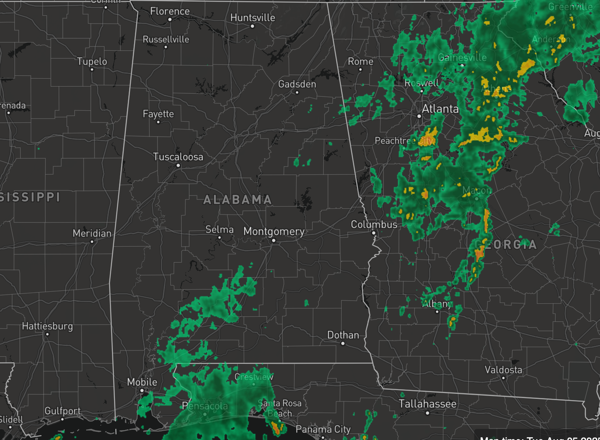
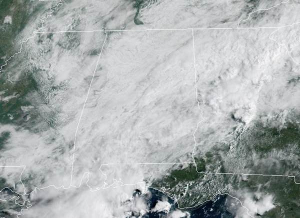
RAIN TO THE EAST: Widespread rain continues to our east across portions of East and Southeast Alabama and through out Georgia as the “wedge” holds on a little longer. A flood watch remains in effect for these areas with afternoon temperatures in the 70s and lower 80s. For the rest of Alabama, we are seeing more clouds than sunshine, with afternoon highs in the low to mid 80s. There will be some showers and storms, but more scattered in nature with most of the rain remaining to the east and southeast.
BIRMINGHAM ALMANAC: For August 5th, the average high for Birmingham is 91° and the average low is 72°. The record high is 102° set in 1947, while the record low is 59° set in 1950. We average 0.15” of precipitation on this date and the record value is 1.49” set in 1941.
USA BRIEF: Wildfire smoke continues to result in poor air quality from the Upper Midwest into the Northeast. Multiple days of hot, dry and windy conditions are expected to bring fire weather concerns for portions of the Four Corners region into the central Great Basin and Rockies. Heavy rainfall and a flash flooding threat continues in the Southeast. Severe thunderstorms continue across the Northern Plains.
REST OF WEEK: Tomorrow through Friday, we slowly return to a more routine August weather pattern for Alabama with temperatures climbing into the mid to upper 80s, with a few low 90s possible. The days will feature a mix of sun and clouds, with widely scattered showers and storms, mainly during the afternoon and evening hours. Rain chances will be in the 30-40% range.
ROUTINE AUGUST WEEKEND: Afternoon highs in the upper 80s and lower 90s with some afternoon and evening showers and storms on a daily basis. Nothing unusual for mid-August in Alabama. As we roll into next week, heat levels will continue to climb and low to mid 90s are expected to return, with only isolated, pop-up showers and storms. We have a lot of summer left to get through in Alabama and know the hottest temperature ever recorded in Alabama occurred in the month of September.
IN THE TROPICS: Three features the National Hurricane Center continues to monitor. For now, no threat to Alabama or the U.S. from any of the features.

TROPICAL STORM DEXTER: At 1100 AM AST, the center of Tropical Storm Dexter was located near latitude 38.0 North, longitude 63.4 West. Dexter is moving toward the northeast near 12 mph and a gradual turn toward the east-northeast is expected during the next few days. Maximum sustained winds are near 40 mph with higher gusts. Some strengthening is forecast during the next 48 hours as Dexter starts to become an extratropical cyclone. Tropical-storm-force winds extend outward up to 115 miles from the center. The estimated minimum central pressure is 1005 mb (29.68 inches).

Elsewhere, off the Southeastern United States, a weak surface trough currently located several hundred miles off the coast of the southeastern United States is expected to form an area of low pressure in a day or so. Thereafter, environmental conditions appear favorable for gradual development of this system, and a tropical depression could form by the latter portion of this week or weekend as as the low initially moves slowly westward, but turns more northward by this weekend. Formation chance through 7 days…medium…40 percent.
Also, in the Central Tropical Atlantic, a tropical wave over the far eastern tropical Atlantic is currently producing disorganized shower and thunderstorm activity, primarily to the southwest of the wave axis. Environmental conditions are forecast to be conducive for gradual development during the next few days, and a tropical depression could form late this week or over the weekend as the system moves generally west-northwestward across the central tropical or subtropical Atlantic. Formation chance through 7 days…medium…50 percent.
The next names up are Erin and Fernand.
WORLD TEMPERATURE EXTREMES: Over the last 24 hours, the highest observation outside the U.S. was 122.7F at Amarah, Iraq. The lowest observation was -103.2F at Concordia, Antarctica.
CONTIGUOUS TEMPERATURE EXTREMES: Over the last 24 hours, the highest observation was 114F at Tolleson, AZ. The lowest observation was 29F at Grand Lake, CO.



