


ALABAMA SATURDAY
A cold front pushed through Alabama on Saturday, sparking areas of rain and a few storms. Florence picked up over an inch in 24 hours, while Huntsville measured just over a half inch. Most of the storms remained below severe limits, with winds topping out between 40 and 50 mph. The strongest storm came Saturday morning in Lamar County, where a severe thunderstorm warning was briefly issued for the potential of 60 mph gusts.
ALABAMA THIS MORNING
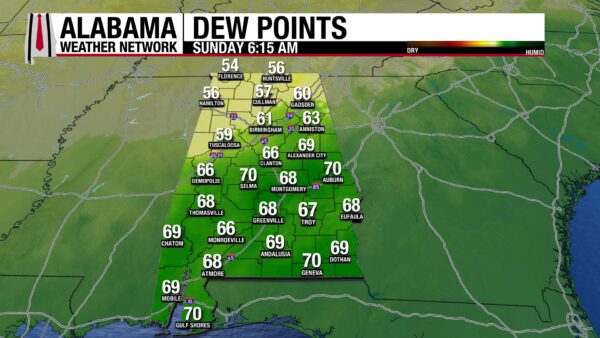
North Alabama woke up to a refreshing change this morning, with temperatures and dewpoints down in the 50s from Florence to Huntsville to Cullman. Farther south, Birmingham reported dewpoints in the low 60s, still a noticeable drop from recent muggy mornings. The front’s impact is being felt most strongly across the northern half of the state, delivering a welcome taste of early fall.
SPANN SKYWATCHERS
Skywatchers shared their rainfall totals from Saturday’s front. Jeff Jacobs in Orange Beach measured 0.14″. Randal Stidham in Winfield checked in with 0.26″. Michelle Miklik in Weaver reported 0.40″, and Leslie Hatton in Scottsboro led the group with 0.55″.
ALABAMA WEATHER FORECAST
TASTE OF FALL ARRIVES FOR THE NORTH
Cooler and drier air has settled into North Alabama behind the front, bringing a true taste of early autumn. Afternoon highs today will only reach the upper 70s to near 80, with sunshine and a northwest breeze gusting up to 15 mph. Tonight will be even cooler than earlier forecasts suggested, with lows dropping into the lower to mid-50s and some valleys slipping into the upper 40s. Monday will continue the crisp pattern with highs in the upper 70s to lower 80s, before moderating into the low to mid-80s on Tuesday.
DRY AND PLEASANT CENTRAL COUNTIES
Central Alabama stays rain-free today under high pressure, with highs in the mid to upper 80s and noticeably lower humidity. By Monday, dewpoints may rebound slightly as northeast to east flow develops. Most of the region will stay dry, though an isolated shower or storm cannot be ruled out in the far southeast counties with afternoon heating. Otherwise, a stretch of comfortable late-summer weather is in place, with temperatures gradually warming through midweek.
SOUTHERN AREAS FEEL A BRIEF DRY PUSH
Across South Alabama, a second front moves through today and stalls over the northern Gulf. Behind it, much drier air briefly filters in, with dewpoints dropping into the upper 40s to low 50s tonight. The dry spell will be short-lived, as moisture returns Monday from the east. Isolated to scattered showers and thunderstorms are possible across the southern half of the region Monday and Tuesday afternoons, especially near the coast. Highs will hold in the upper 80s to lower 90s, with lows ranging from the mid to upper 60s inland to the lower 70s along the beaches.
SOUTHEAST ALABAMA TRANSITIONS TO DRIER AIR
A weak front slides across Southeast Alabama today, sparking scattered showers and thunderstorms this afternoon. Lows tonight will fall into the low to mid-60s across Southeast Alabama and Southwest Georgia, while areas farther south remain in the low 70s. On Monday and Tuesday, the best rain chances will remain near the Gulf Coast counties, while inland areas dry out as dewpoints fall back into the mid to upper 60s. By late week, the boundary settles farther south, and drier air with dewpoints in the 50s to low 60s spreads into the region.
EXTENDED TREND
Through mid to late week, high pressure builds and temperatures gradually warm. Highs climb into the upper 80s to lower 90s by Thursday and Friday, but humidity stays tolerable across the north. Gulf influence keeps the south more humid, though overall conditions remain far less oppressive than last week.
DANCING WITH THE STATS
The early taste of fall shattered records across parts of the Plains and Rockies on Saturday. Ottumwa, IA dipped to 42°, breaking its old mark of 43° set in 2011. Farther west, Sheridan, WY dropped to 31°, breaking a record that had stood since 1918. Montana also felt the chill — Baker fell to 30°, smashing its previous record of 36° from 2008. Sioux City, IA reached 38°, edging out its 1956 record by a degree.
NATIONAL WEATHER STORY
An upper low over the Great Lakes keeps the Northeast and Mid-Atlantic unsettled today, while a stalled front along the East and Gulf Coasts fuels additional showers and storms into midweek. Moisture from the Gulf drives scattered thunderstorms across southern Texas today, lifting into the Plains and Upper Midwest by Monday. Florida remains locked in a daily cycle of afternoon downpours, with locally heavy rain also possible along the Carolina coast midweek. Out West, a series of disturbances brings multiple days of rain to the Pacific Northwest and Northern Rockies, with early-season snow possible at higher elevations. Smoke continues to prompt air quality alerts in parts of the Northwest, while frost and freeze warnings are posted in the Upper Midwest under cooler high pressure. The broad pattern persists through late week, with a warm ridge over the Plains sandwiched between troughs on both coasts, keeping the central U.S. warmer than average while the East and West see repeated rounds of rain.
The nation’s high on Saturday reached 110°F at both Death Valley and nearby Stovepipe Wells, California. On the other end of the spectrum, the day’s low was a frosty 23°F reported 16 miles west of Redfeather Lakes, Colorado.
SEVERE OUTLOOK
The Storm Prediction Center has introduced a Marginal Risk for severe thunderstorms today across portions of the central and southern High Plains. Scattered storms are expected to form this afternoon from eastern New Mexico and Colorado into western Kansas, supported by strong surface heating and increasing wind shear. A few storms may organize into supercells, capable of producing isolated hail and gusty winds as they spread southeast toward western Kansas and the Texas and Oklahoma Panhandles this evening.
FLASH FLOOD OUTLOOK
Moisture from the Gulf, combined with remnants of former Hurricane Lorena, will fuel scattered storms across southern Texas today. The heaviest rainfall is expected near the Rio Grande and south of I-10, where isolated flash flooding could occur.
Farther east, a stalled front across Florida and the Southeast coast will spark rounds of afternoon and evening storms. Much of the Florida Peninsula is under a Marginal Risk for flash flooding, especially where slow-moving storms track over urban areas or recent wet spots. That risk extends northward into coastal portions of the Carolinas, though the most intense rainfall should remain offshore.
TROPICS
The National Hurricane Center reports that tropical cyclone formation is not expected anywhere in the Atlantic, Caribbean, or Gulf over the next seven days. The disturbance we have been watching has fizzled out.
BEACH
Beach conditions stay generally calm today with surf around 1 foot and water temperatures in the mid-80s. Rip current risk is low at Dauphin Island, Gulf Shores, Orange Beach, and Pensacola. However, the South Walton beaches carry a moderate risk, where stronger currents are possible — swimmers should use extra caution and stay near lifeguards. Skies will be sunny with highs in the upper 80s to near 90, and the UV Index remains very high.
WEATHERBRAINS
Episode 1025 of WeatherBrains will broadcast live from the National Weather Association Annual Meeting in Huntsville, AL. The show will feature conversations and insights directly from the conference floor, highlighting key voices and timely topics from one of the nation’s premier gatherings of meteorologists. It will stream live Monday evening at 7 PM CDT on youtube.com/weatherbrains, with playback available the following day at weatherbrains.com and on all major podcast platforms.



