


STILL DRY TODAY: With a partly to mostly sunny sky temperatures rise into the 70s again today across Alabama. Clouds will increase tonight.
ACTIVE DAY TOMORROW: A large area of rain with a few thunderstorms will move into the state after midnight tonight. You will probably hear some loud thunder during the pre-dawn hours, but with no surface based instability we do not expect any severe storms with this activity.
After a lull tomorrow morning, additional showers and a few storms will form during the afternoon hours ahead of a surface front. SPC has all of Alabama in a low end, “marginal risk” (level 1/5) of severe thunderstorms.
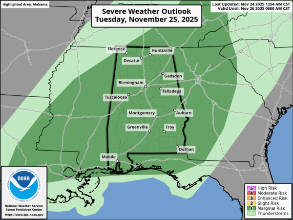
The primary dynamic support will be pulling away from Alabama tomorrow afternoon, and the air will be pretty worked over by the pre-dawn rain. So the overall severe threat is relatively low. A few of the heavier storms could produce small hail and gusty winds. The chance of a brief isolated tornado is very low, but not zero.
Rain amounts will be in the 1-2 inch range for North Alabama, with amounts under one inch for the southern counties.
Wednesday will feature a clearing sky and cooler temperatures; highs will be in the 57-64 degree range.
THANKSGIVING: Thursday will be dry with a cold morning; we start the day in the 30s, with a freeze for the northern third of the state. With a sunny sky temperatures rise into the 47-54 degree range by afternoon.
A freeze is likely for most of the state Friday morning; Friday will be sunny cool with a high in the 50s.
THE WEEKEND: Saturday stays cool and dry with a high in 50s and low 60s, but clouds will increase Saturday night, and global models show another large area of rain moving through the state Sunday. See the video briefing for maps, graphics, and more details.
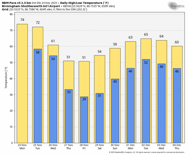
IRON BOWL FORECAST: The weather will be dry and cold for the biggest football game of the year in Alabama Saturday night (Alabama at Auburn, 6:30p CT kickoff at Jordan Hare Stadium). Temperatures will be in the 40s.
ON THIS DATE IN 2001: Thirty six tornadoes touched down in Alabama on November 24, 2001. The first major tornado of the day cut a 39 mile path from near Kennedy in Lamar County to just south of Carbon Hill in Walker County. Two people died in a mobile home near Kennedy.
An F2 tornado cut a short path through the town of Haleyville in Winston County just before 11:30 a.m., injuring thirteen people. Just northeast of Birmingham, an F2 tornado moved along I-59 near Argo as it cut a nearly 14 mile path into St. Clair County.
The strongest tornado of the day touched down about 1:19 p.m. CST southeast of Oneonta in Blount County. The tornado produced three distinct areas of F4 damage. The other two fatalities of the day occurred near Sand Rock in Cherokee County just after 3 p.m. as an F2 tornado cut an 8 mile path. Again, the fatalities were in a mobile home.
Prior to storms moving into Alabama that day, several tornadoes touched down in Mississippi during the pre-dawn hours… including two F4 tornadoes across Washington and Bolivar Counties at around 2a CT and in Madison County near the city of Madison at around 5a CT. The second tornado killed at least 2 (including a newborn baby) and injured 21. Another tornado in Mississippi, an F2, struck Quitman, Panola and Tate Counties just after 3a CT and killed at least three.
Look for the next video briefing here by 3:00 this afternoon… enjoy the day!



