


Cloud cover and scattered rain have been the story across much of Alabama today, with conditions varying noticeably from north to south. In northwest Alabama, including Florence and Cullman, steady rain fell through the morning under low clouds, with temperatures holding in the low-to-mid 60s. Dew points climbed into the mid 60s in western sections, signaling very moist air in place, while locations farther east, including Huntsville, remained slightly drier with lower dew points and cooler temperatures at higher elevations like Monte Sano.
Across Central Alabama, rain moved through Birmingham and Tuscaloosa earlier, leaving behind overcast skies, temperatures in the low 60s, and gusty winds at times approaching 30 mph. While thunderstorms have been limited so far, the atmosphere remains unsettled, especially across western and southwestern portions of the state where moisture is deeper. Montgomery and much of east-central Alabama stayed mostly dry through midday, though showers were beginning to approach from the west.
South Alabama has seen a different picture altogether. Fairhope and Dauphin Island experienced warmer temperatures, some breaks in the clouds, and a more humid feel, with readings climbing into the upper 70s near the coast. Winds have been gusty at times along the Gulf, but conditions have generally been calm compared to areas farther north where rain has been more persistent.
Looking ahead, multiple waves of rain and storms are expected through tonight and into Saturday. The primary concern will be heavy rainfall, with many locations picking up two to three inches and locally higher totals possible where storms train over the same area. Flash flooding is not occurring at this time, but it remains a concern if heavier rain sets up over a short period. A few strong storms are also possible, mainly across western, southwestern, and south-central Alabama, though instability remains limited.
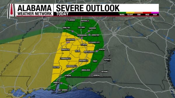
The Storm Prediction Center has placed parts of west and southwest Alabama under a Level 2 (slight) risk for severe weather today. While the overall severe threat is low, gusty winds remain the main concern, with a very small chance of an isolated tornado. Additional storms may linger into Saturday morning, followed by clearing skies and a sharp turn toward colder weather by Sunday. Highs will struggle to reach the 40s and 50s early next week, with cold nights dropping into the 20s as dry air settles in behind the front.
As this system moves through, residents are encouraged to stay weather-aware, especially overnight. Have multiple ways to receive warnings, including a NOAA Weather Radio and the Alabama Weather Network app, which provides real-time alerts and live coverage. While the rain will be beneficial for easing drought conditions across much of the state, caution is urged around flooded roadways—remember to turn around, don’t drown.



