


Daily Weather Briefing
Sunday, January 11, 2026
ALABAMA YESTERDAY
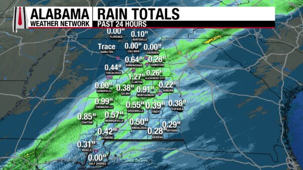
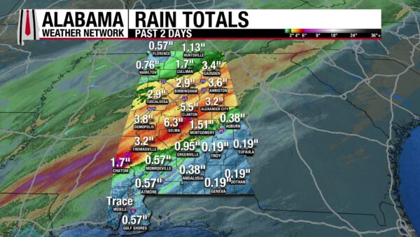
An active day of weather took place yesterday, as Flash Flood Warnings, Severe Thunderstorm Warnings, and even a Tornado Warning were issued for the central and southern portions of the state. Intense rainfall, loud thunder, and frequent lightning were the main impacts of the storms, which moved from west to east from early morning to evening. They became less intense and sub-severe as they tracked east. The last showers exited the southeastern corner of the state by around 7 PM. Across the state, rainfall in the previous 24 hours measured between 0.2” and 1.4”. The rainfall amounts over the past two days are more substantial, with areas such as Demopolis, Clanton, and Selma receiving 3.8”, 5.5”, and 6.3” respectively. This is much-needed rain, and drought conditions are expected to improve. Highs ranged from the mid to upper 60s north to the mid to upper 70s south, with a few locations even reaching 80 degrees.

ALABAMA THIS MORNING
This morning is quiet, with a few thin clouds over south Alabama, while skies are clear everywhere else. Temperatures are chillier than last week, sitting in the upper 30s from the north to middle part of the state, and in the 40s to low 50s in the south. However, winds are gusting in the teens and the upper 20s, keeping wind chill temperatures about 10 degrees below the actual temperature.
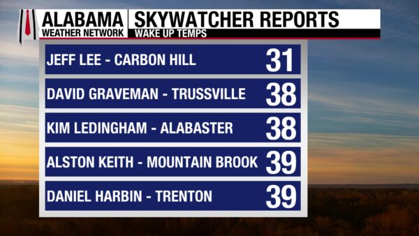
Skywatchers observe temperatures in the 30s on this quiet morning.
Join the team! Learn how to become a Spann Skywatcher: https://www.spannskywatchers.com/
ALABAMA 7 DAY FORECAST
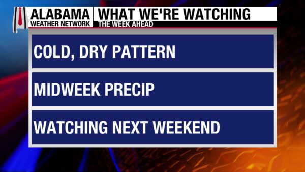
Winter returns this week as a reinforcing cold front will bring strong wind gusts and cold temperatures to the sunny state today. Monday and Tuesday will be dry and cool, then a chance for showers is expected Wednesday along with another cold front. Thursday will be chilly, and another cold front is expected this weekend.
COOL AND WINDY SUNDAY
As the cold front moves through the state today, winds will gust between 20 and 30 mph, tapering into the teens in the north starting in the late afternoon. Highs will be in the mid 40s north and the lower 50s to upper 50s in central and south Alabama. Wind chill temperatures will stay around 10 degrees below the high. Sunny skies dominate the day.
COLD TONIGHT
Calming winds and clear skies in the north and central parts of the state will allow radiational cooling overnight. Temperatures will be in the mid to upper 20s. South Alabama will be clear, but winds will be stronger, keeping temperatures to the low 30s.
MODERATING MONDAY
After a cold start, calm winds and abundant sunshine will allow highs to rebound into the upper 40s to mid 50s statewide. The forecast stays precipitation-free.
WARMING TUESDAY
Highs will range from the mid 50s north to the upper 50s south as high pressure encourages sunny skies, light winds, and dry conditions. Tuesday will be the warmest day of the week.
SHOWERY WEDNESDAY
A cold front will bring a lower-end precipitation chance to the state Wednesday. Highs will climb to the low 50s north to the upper 50s south.
CHILLY THURSDAY
Thursday is shaping up to be the coldest day of the week, as cold air rushes into the state in the wake of the cold front. Highs will manage to reach the mid to upper 30s in the north and low to mid 40s in the south. Skies will be clear once again.
SLIGHT THAW FRIDAY
A quick thaw from cold temperatures will happen Friday. Highs will be able to reach the upper 40s to mid 50s.
COLD FRONT EXPECTED THIS WEEKEND
A cold front will impact the state this weekend, but exactly when is still to be determined. Highs Saturday will be in the low 40s to mid 50s, and precipitation stays out of the state for now.
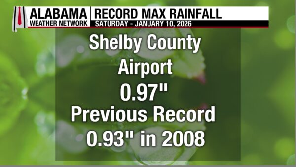
SHELBY COUNTY AIRPORT RAINFALL
A total of 0.97 inches of rainfall was measured at the Shelby County Airport yesterday, surpassing the 2008 record of 0.93”.
RELENTLESS WINTER NORTH
A wintry mix moves over the Hudson Valley and Upper New England through tonight, producing rain, freezing rain, and snow in the region. The main concern with this event is icing of the roads. Upper elevations in Maine are expected to receive heavy snow as well.
Snow squalls move into the Ohio Valley and Mid-Atlantic behind this system, leading to snow accumulations of an inch or more. Reduction in visibility and flash freezes could create hazardous travel conditions.
RAIN FOR COASTAL WASHINGTON
Moderate rainfall amounts of 3-4″ will fall over Coastal Washington through Monday, but little danger comes from this rain.
NATIONAL HIGH AND LOW
Yesterday, Plant City and Everglades City, Florida, reached the national high of 88 degrees, while Angel Fire, New Mexico, recorded the national low of –22 degrees.
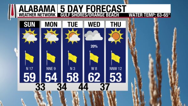
BRISK SHORES TODAY
Highs along the shoreline today will be in the upper 50s, but winds around 20 mph will feel brisk. The rip current risk is low, and the surf height is 2 to 3 feet. A small craft advisory is in effect today. This week is looking bleak in terms of a potential good beach day, with cool highs and cloudy skies in the forecast.

WEATHERBRAINS 1043:
Tomorrow’s WeatherBrains episode features Jim Abraham and Ken Macdonald, returning guests! Expect a deep dive into questions and discussions sparked by their previous episode.
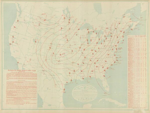
TODAY IN WEATHER HISTORY
January 11, 1885 – Violent Winter Outbreak in Alabama
On January 11, 1885, a widespread and destructive tornado outbreak swept across Alabama, producing at least six significant tornadoes and causing ten deaths and more than 80 injuries. The most violent storm was an F4 that traveled roughly 80 miles from Boligee to northeast of Jemison, destroying large farmhouses along a path up to 400 yards wide. In northern Alabama, an F2 tornado crossed Blount, Cullman, Marshall, and DeKalb Counties, killing a child near Collinsville and injuring many others along its 35-mile track. Another deadly tornado, rated F3, tore through Lamar, Fayette, and Walker Counties, destroying more than a dozen plantations and killing one person. A long-track F3 in Coosa, Clay, and Randolph Counties destroyed 16 farms and caused two fatalities, while a separate F3 in Macon County hit several settlements near Little Texas, killing one man. The outbreak stands as one of Alabama’s most significant winter tornado events of the 19th century.
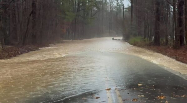
IMAGE(S) OF THE DAY
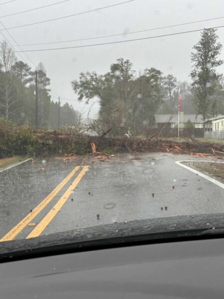
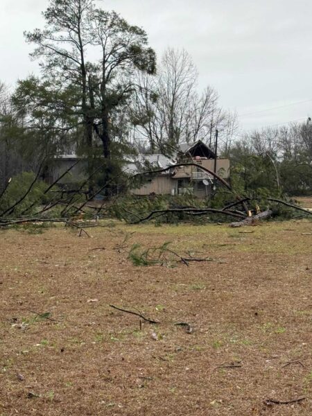
Today’s Images of the Day feature pictures of damage sent in by Skywatchers during the storm yesterday.
The first picture shows the flooded Dry Creek Road in Pell City, submitted by Joey Amberson.
The second photo of a downed tree on Jasmine Hill Road in Wetumpka was taken by Skylar Blackerby.
Ron Lipham sent this photo of fallen tree limbs west of Selma.



