


Daily Weather Briefing
Sunday, January 18, 2026
Watch the Alabama Weather Network live coverage from this morning:
ALABAMA YESTERDAY
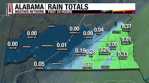
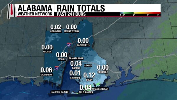
The northern half of Alabama stayed dry and cloudy yesterday, hitting highs in the low 40s and mid 50s. In eastern south-central and south Alabama, rain showers were on and off throughout the day. Highs stayed in the mid to upper 50s. Rain was consistent in south Alabama from the afternoon through the night. Rain totals stayed below 0.4″.
ALABAMA THIS MORNING
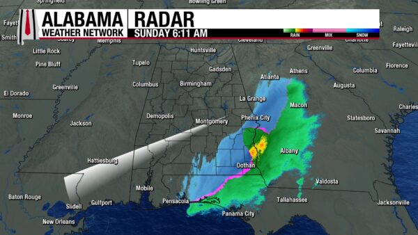
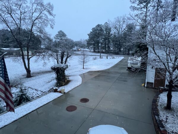
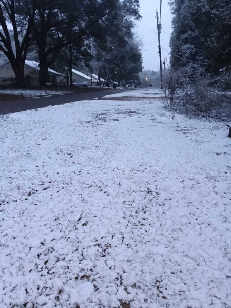
Most of the state is dry this morning, except for the coast and southeast Alabama, where a mix between rain and snow is falling this morning. As a Gulf low continues to travel eastward, temperatures have been falling as an associated cold front moves through Alabama. As temperatures fall, the rain that has been falling overnight has switched to snow. Impacts to travel are not a concern, as roads are only wet, but snow is accumulating on grassy areas. Temperatures sit in the 20s north and low 30s in central and south Alabama. A Winter Storm Warning is in effect until 11 A.M. for portions of southeast Alabama, and surrounding areas are under a Winter Weather Advisory until noon today.
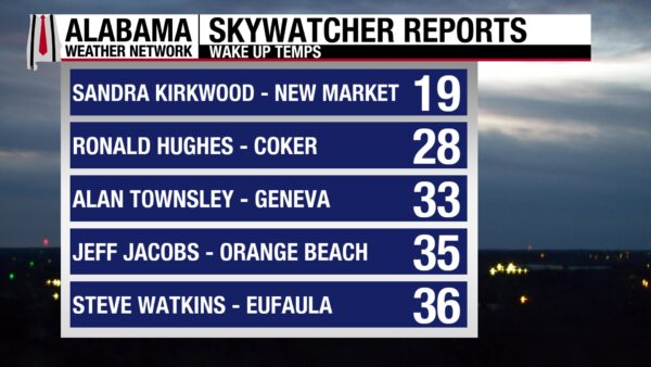
Skywatchers are observing temperatures ranging from the upper teens to the mid 30s this morning.
ALABAMA 7 DAY FORECAST
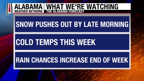
Today’s snow moves out by mid-morning, and the entire state will be cold. Cold and dry conditions persist until around Wednesday night, when precipitation chances increase ahead of a cold front that will sweep through the state Thursday. Friday will be dry and seasonable, before a low-pressure system brings rain chances to the weekend.
COLD SETTLES IN FOR THE WEEK
Behind a reinforcing cold front that will enter the state today, cold temperatures rush in. Highs today will struggle to reach the upper 30s in the north and the low to mid 40s in the south. Once the snow clears out around 9 A.M. this morning, skies will be sunny and winds will be out of the west-northwest.
CLEAR AND COLD TONIGHT
Temperatures tonight will range from the lower 20s north and upper 20s south. Cloudless skies continue, but winds staying around 5 to 10 mph will keep temperatures from getting into the teens in the north.
COLD AND DRY MONDAY AND TUESDAY
The long weekend will end with dry, clear conditions throughout the day on Monday. Highs will have the opportunity to rise into the low 40s north, and mid 40s to low 50s in the central and southern portion of the state both days.
SLIGHTLY WARMER WEDNESDAY
Temperatures Wednesday will climb to the upper 40s north and mid 50s south. Clouds will begin to increase through the day ahead of a cold front. Low rain chances creep into the forecast Wednesday night and persist through Thursday morning.
RAIN THURSDAY MORNING
Temperatures on Thursday are similar to Wednesdays. As of now, the rain chance should be out of the state by the morning hours, and most of the day will be dry.
DRY AGAIN FRIDAY
The skies will be dry Friday, and temperatures will range from the low 50s north to the low 60s south.
RAINY SATURDAY
A low-pressure system will bring increased rain chances to Alabama, especially to the north, starting early Saturday morning and lingering throughout the day. Temperatures will be in the upper 40s in the north but reach all the way to the mid 60s south.
MADISON, WI, SNOW
5.6” of snow fell in Madison, Wisconsin, yesterday. This broke the record of 5.0”, set in 1953.
SNOW FOR EAST
Along with Alabama, central Georgia, and parts of Florida will receive snow this morning. Most places won’t get more than an inch, but locally higher amounts of 2-4 inches can be expected in central Georgia. The snow will continue northeastward, into the Mid-Atlantic and Northeast, through this evening. 3-6” are expected through tomorrow.
WINTER HITS PLAINS AND UPPER MIDWEST HARD
Snow showers and gusty winds will impact the Northern Plains and Upper Midwest this afternoon, with Blizzard Warnings in effect in North Dakota and Minnesota. Travel will be dangerous and can become life-threatening. Several inches of snow will fall in the Great Lakes area until Tuesday.
NATIONAL HIGH AND LOW
Santa Ana, California, observed the national high yesterday of 88 degrees. Bottineau, North Dakota, fell to a low of –18 degrees.
VERY COLD BEACH DAY
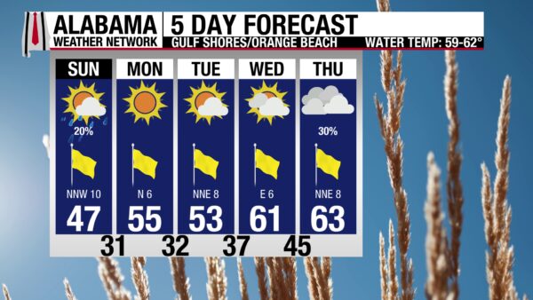
After some flurries fell this morning along the coast, highs will only rebound to the upper 40s. Waters will be calm, with a low rip current risk and surf height at 1-2 feet. Winds will be from the northwest at 10 to 15 mph, and skies will be sunny. Warmer temperatures are expected later this week.
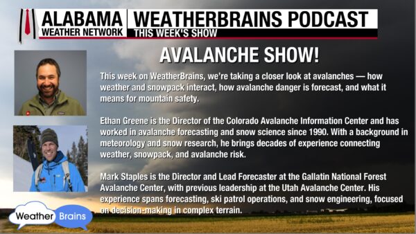
WEATHERBRAINS 1044:
This week’s WeatherBrains episode features two avalanche experts, Ethan Greene and Mark Staples. They will talk about how avalanche danger is forecast, weather and snowpack, and mountain safety. The episode airs tomorrow!
TODAY IN WEATHER HISTORY
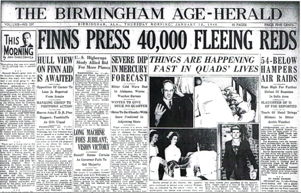
January 18, 1940 – Birmingham’s Coldest Two Weeks
On January 18, 1940, E.C. Horton, the James Spann of the 1930s and 40s, alerted residents of Birmingham that a Severe Cold Wave Warning had been issued by the Weather Bureau Forecast Office in New Orleans. A cold wave was defined as a drop in temperature of 20 degrees or more to 20F or less, but an even sharper dip was expected. Horton called for a low of 4F-12F during the coming night. Clouds arrived during the late afternoon hours over North Alabama, and the snow reports began to fly in. By 5 p.m., it was snowing in Decatur. By 8 p.m., Cullman was reporting 2 inches of snow on the ground and a temperature of 11 degrees. By morning, lows as cold as 20 degrees would even reach the coast. In Birmingham, police called for ashes to be spread on 20th Street, the main thoroughfare over Red Mountain. Partly cloudy and continued cold was the forecast which proved to be an understatement. Indeed, the fourteen days between the 18th and the 31st would be the coldest 14-day period in Birmingham with an average temperature of 22.5F. No other fourteen-day period even comes close (omitting overlaps). The period from February 8-21, 1958, comes in second with 27.1F.
IMAGE(S) OF THE DAY
Today’s Images of the Day come from two Skywatchers who sent in photos of this morning’s snow in the south! The first photo is from David Jett in Eufaula, and the second is from Alan Townsley in Geneva. What pretty pictures!



