


Daily Weather Briefing
Wednesday, January 28, 2026
ALABAMA YESTERDAY
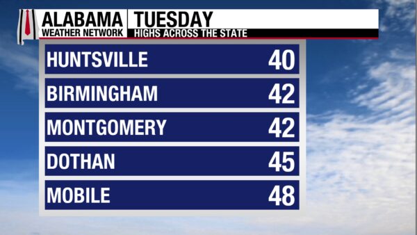
A sunny day took place yesterday, allowing temperatures to “warm” to the low to mid 40s from north to south. The state was breezy at times, with infrequent wind gusts sometimes reaching the low 20s.
ALABAMA THIS MORNING
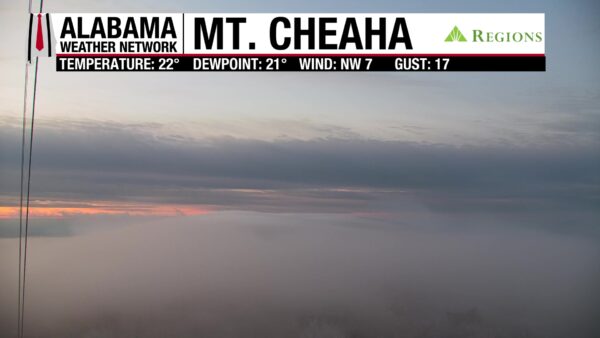
Skies are shifting between mostly clear and clear this morning, and winds stay below 10 mph. Fog has developed across much of the north. Morning temperatures are significantly warmer than they were yesterday, but they are still below freezing. Mid 20s to low 30s span the state.
Our Mt. Cheaha cam captures the morning fog and a small glimpse of the pink-orange sunrise!

The Skywatchers are sending in reports of temperatures in the 20s.
ALABAMA 7 DAY FORECAST
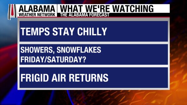
This week continues to be chilly, and a relatively dry cold front Friday brings a low chance of precipitation to the state. Frigid temperatures and strong winds follow the front, shaping a very cold weekend. Next week will feature temperatures attempting to recover.
SLIGHTLY LESS COLD TODAY
Some clouds may linger through the morning but clear out by the afternoon. Highs will range from the low to mid 40s north, the upper 40s in central Alabama, and the low to mid 50s south. Winds will stay light.
CHILLY NIGHT
Less winds and clear skies equal a great night for radiational cooling. Lows will be in the low 20s north and mid to upper 20s farther south. The coast will be around 30 degrees.
EVEN LESS COLD TOMORROW
Tomorrow, clear skies will encourage temperatures to reach the mid to upper 40s north, and low to mid 50s from central to south Alabama.
STRONG COOL DOWN BEGINS FRIDAY
A mostly dry cold front will begin to move through the state Friday, bringing high temperatures in the north down to the upper 30s and low 40s. Centrally, temperatures will be in the mid to upper 40s, while the south will manage the low to upper 50s. There is a very low (but not-zero) chance of precipitation with this front, as moisture availability is low. The precipitation might fall as snow flurries, especially in the north, but it depends on whether the cold air is fast enough behind the front.
BITTERLY COLD WEEKEND
Friday’s cold front is going to bring another blast of Arctic air to the Southeast. High temperatures Saturday will be well below average, with the north staying in the low 20s, the upper 20s and mid 30s centrally and in the south. A strong temperature gradient and strong cold air advection will keep wind gusts high and wind chills very low Friday night through Saturday night. Bundle up this weekend and protect the 4 P’s! Temperatures will “rebound” Sunday into the low 30s north, mid 30s centrally, and low 40s south.
DRY AND WARMING UP NEXT WEEK
Monday and Tuesday will be dry, and highs will slowly start to see improvements. Monday highs will range from the low 40s north to the low 50s south. Highs Tuesday will climb to the upper 40s north and upper 50s south.

PROTECTION FROM THE COLD
You must protect yourself, your people, your pipes, and your plants as we gear up for a cold week. Read the graphic above to learn more about how to protect the 4 P’s!
COLD AT THE AIRPORT
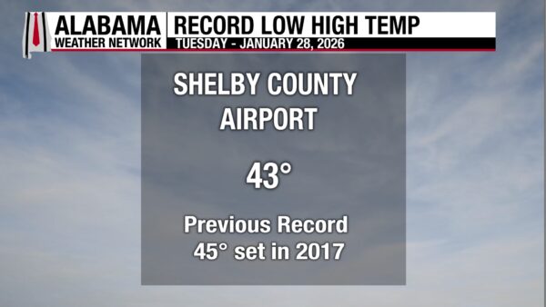
The high temperature at Shelby County Airport was 43 degrees. This breaks the previous record-low maximum temperature of 45 degrees, set in 2017.
SNOW IN THE NORTH
Lake-effect snow will affect the Great Lakes through Friday. Upslope snow will fall from this afternoon until Friday in the Northern and Central Plains.
SHOWERS IN THE SOUTH
Scattered showers will move through the Lower Mississippi tomorrow evening. Light rain will fall through Friday on the tip of Florida.
RAIN AND SNOW FOR WEST
Rain will fall along the Pacific Northwest Coast through Friday, while snow will fall in higher elevations. Additionally, the Rockies and Intermountain regions will receive snow through Friday.
NATIONAL HIGH AND LOW
Pala, California, reached the national high of 79 degrees yesterday, while Crested Butte, Colorado, fell to the national low of –20 degrees.
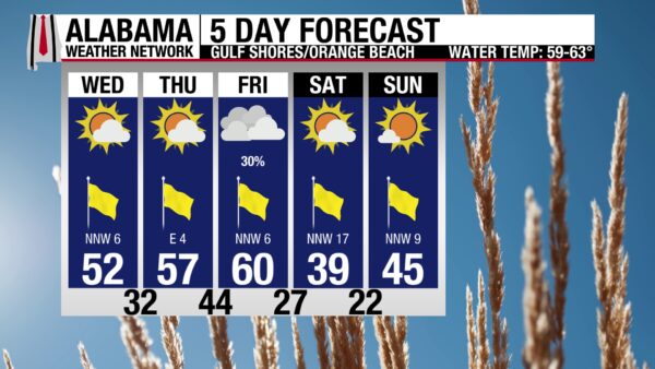
COLD BUT NICE BEACH DAY
Despite a high temperature in the lower 50s, conditions line up for a pleasant day on the beach. Winds will be lighter, skies will be mostly sunny, and waters will be calm. A low rip current risk is in effect, and the surf height maxes around 1 foot.

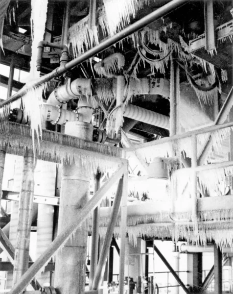
TODAY IN WEATHER HISTORY
January 28, 1986 – The Challenger Disaster
On January 28, 1986, weather played a large role in a defining tragic moment in the United States’ history. The NASA space shuttle Challenger’s mission was to launch the second Tracking and Data Relay Satellite and release the Spartan Halley aircraft. The crew of the shuttle included teacher Christa McAuliffe, commander Francis (Dick) Scobee, pilot Michael Smith, mission specialists Ellison Onizuka, Judith Resnik, and Ronald McNair, and engineer Gregory Jarvis. A few different weather phenomena were intertwined with Challenger’s fate. Bad weather at the land sites for the shuttle Columbia pushed back its landing date as well as Challenger’s launch date. Then, an Arctic air outbreak pushed record-breaking cold into central Florida. Temperatures were around 25 degrees below normal on the morning of the 28th. The temperature in Cape Canaveral fell to a low of 22 degrees, and Melbourne and Orlando set record lows of 26 degrees. The launch was pushed back from 9:38 a.m. to 11:38 a.m. to allow the ice that had formed on the launch pad overnight to melt. While the air temperature at the surface was 36 degrees at takeoff, the air temperature at the height of the Solid Rocket Booster, the failed part of the shuttle, was estimated to be around only 28 degrees and shaded from the sun. It was later determined that the two O-rings, responsible for sealing the joint between the two lower segments of the right-hand solid rocket booster, lost resiliency in the cold temperatures. Along with cold temperatures, wind shear, the changing of wind speed and direction with height, played a role in the shuttle’s failure. A flame began, and the wind pushed the flame to the already leaking hydrogen from the failing O-rings, causing a mixture of combustion and wind forces to tear the shuttle apart. The wind shear that the shuttle underwent was technically within the shuttle’s design limits, but some experts believe the Challenger tragedy would not have occurred if not for the wind shear. Further dives into the accident reveal that cutting corners and trying to do too much at once also led to this fateful day.

IMAGE OF THE DAY
Skywatcher Daniel Harbin sent in this cool photo of frozen rings around the bases of trees in Jackson County. Where the frozen ring forms is how far water has moved up into the tree.



