


Daily Weather Briefing
Saturday, February 14, 2026


ALABAMA THIS MORNING
High clouds cover much of the state this morning. Temperatures range from the low 30s in the northeast to the low 50s in the southwest. Birmingham sits at 50 degrees while surrounding areas such as Alexander City and Tuscaloosa sit at 40 and 44 degrees, respectively.
The Alabaster and Orange Beach Regions Skycams capture gorgeous Saturday sunrises!
ALABAMA 7 DAY FORECAST
Today will be tranquil and dry, except in northwest Alabama, which will see a shower or two. Tomorrow, a line of showers and thunderstorms will begin to move from the west in the morning. There is a low-end severe threat for south-central and south Alabama. Next week will be quiet and dry, with rain chances increasing on Friday.
CLOUDY AND QUIET VALENTINE’S DAY
The weather will be quiet and pleasant, perfect for any Valentine’s Day plans! Skies will be cloudy, with more of the sky expected to be covered in the north than the south today. There is a very low chance for a shower or two in north and north-central Alabama after noon. Highs will reach the lower to upper 60s from Huntsville to Clanton, and the low 70s from Tuscaloosa to Mobile.
RAIN BEGINS OVERNIGHT
After sunset, rain chances increase starting from the south. Showers and thunderstorms will be scattered in nature. Lows will fall to the low 50s north, mid 50s centrally and in the south, and the upper 50s in the southwest and on the coast.
STORMY SUNDAY
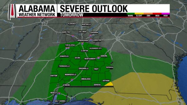
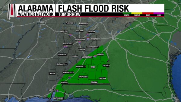
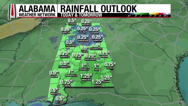
This weekend’s big rainmaker moves into the state between 4 and 7 a.m. tomorrow. A line of showers and thunderstorms will move from west to east through the morning, and it should begin its exit around lunchtime. Scattered storms will linger throughout the afternoon. In north and north-central Alabama, storms will stay sub-severe, but there is a low-end threat for severe weather in the south and south-central portion of the state. The Storm Prediction Center has placed this area under a Marginal Risk (1/5) of Severe Weather Sunday, which means impacts will include strong winds, hail, and the potential for an isolated tornado or two. The very southeastern corner of the state is under a Slight Risk (2/5), so storms could be more intense there. There is potential for severe storms within the first line of storms, as well as the spotted showers behind it. Flash flooding will be a concern for the southeast tomorrow as well, as the Weather Prediction Center has placed it under a Marginal Risk (1/4) for Excessive Rainfall. Isolated flash flooding could occur in poor drainage areas. Anywhere from 0.25”-0.5” of rain can be expected north, while 0.5”-1.25” could fall in the south. Highs will reach the 60s north, and low 70s further south.
Today, make sure you have a severe weather action plan in place if you reside in the south, so you can be prepared for tomorrow’s weather.
DRY THROUGH THURSDAY
Behind the low-pressure bringing Sunday’s storms, a high-pressure system will take hold. Dry conditions and warm temperatures can be expected through Thursday.
Monday, highs will be in the upper 60s north and upper 60s to low 70s south.
The 70s will reach all the way into north Alabama Tuesday, and the south will climb to the mid 70s.
Increasing clouds Wednesday will do little to cool the state down, as highs reach the mid 70s north and upper 70s centrally and in the south.
Thursday will be the warmest day of the week, as the north will see highs in the mid to upper 70s, and the south will teeter between the high 70s and an 80-degree mark! What a warm February day! Rain chances begin to increase overnight.
RAIN CHANCE FRIDAY
Rain chances increase Friday as a cold front approaches the state. Highs will be slightly cooler, topping out at the low 70s north, maybe an upper 60 centrally, and the mid 70s south.
DROUGHT WORSENS ONCE AGAIN
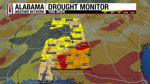
Despite the rains we’ve received this week, they were not enough to keep the drought conditions at bay. Moderate Drought (D1) conditions have increased by about 3% since last week, now sitting at 25.53%. Extreme Drought (D3) conditions have increased as well, jumping from 1.64% last week to 6.27% this week. The good news is that the portions of the state that are drought-free remain unchanged. Hopefully, tomorrow will bring enough beneficial rain to see an improvement in drought next week.

UNSETTLED CONDITIONS
Unsettled beach conditions today are indicative of the active weather we will see tomorrow. The high will be in the upper 60s, skies will be partly sunny, and winds will be from the east at 10 to 15 mph. The rip current risk is moderate today, so life-threatening rip currents are possible in the surf zone. Surf height is 2-3 feet. Tomorrow will need to be spent inside as thunderstorms will dominate the day. Next week, however, we will see the best beach conditions we’ve seen since the warm December.

TODAY IN WEATHER HISTORY
February 14, 1895 – Snow and Love in the Louisiana Air
On Valentine’s Day 1895, a coastal low-pressure system brought record snow amounts from The Texas coast to Louisiana, Alabama, southern Georgia, and north Florida. 50 miles from the Gulf in Rayne, Louisiana; 2 feet of snow fell. This is the state’s all-time single storm record! 15.4” was measured in Galveston, and 20” was observed in surrounding areas. 22” fell in Beaumont, resulting in cattle dying “in piles” as they struggled to survive the cold. 15” was recorded in Cameron. Even at the mouth of the Mississippi River at Port Eads, two inches of snow were measured. In Baton Rouge and New Orleans, 12.5” and 8.5” fell, respectively. The system brought large snow amounts eastward as well, with 8.6 inches in Hattiesburg and 6.2 inches in Biloxi, Mississippi. Here in Alabama, Mobile recorded 6 inches of snow, its all-time record until January 2025. Reports of snow totals of three to five inches came out of South Georgia and north Florida. Stories came out of Texas and Louisiana of snowball fights, some with good intentions and some with bad intentions. One story includes a group of boys and men putting small stones and coals in their snowballs, then throwing them at passersby. This resulted in injuries such as knocked out teeth. Many of these records, especially in Louisiana, still stand today.

IMAGE OF THE DAY
@TommyHornWX1 on X posted this photo of “Beautiful cloud iridescence” over Paul Smiths, New York, yesterday. How cool!

Happy Valentine’s Day!



