


Daily Weather Briefing
Sunday, March 1, 2026
ALABAMA THIS MORNING
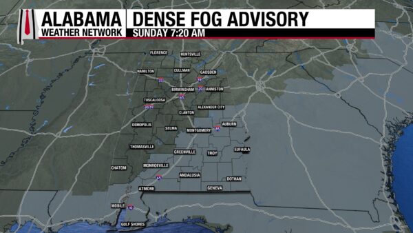
Skies are clear in the north and west this morning, while the east and south sit under a Dense Fog Advisory until 9 a.m. If you are planning on driving, increase your following distance and proceed with caution, as visibility will be poor at times. Temperatures sit in the low to mid 40s in the northern half of the state. The southern half of the state is seeing readings mostly in the mid 40s too, but pockets of fog keep some areas to the upper 40s and lower 50s.
ALABAMA 7 DAY FORECAST
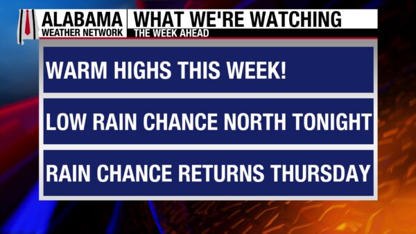
We start off March, and the first day of meteorological spring, with a spring-feeling day! Light showers will move through north Alabama early tomorrow morning through the afternoon. The rest of the state will be dry and sunny. Tuesday and Wednesday continue the dry trend, but clouds will be present each day as southeast flow advects moisture into the state. Rain chances increase Thursday and stick around into the weekend.
PLEASANT START TO MARCH
Dry, warm, and partly cloudy conditions will dominate the state today. Highs will reach the mid 70s north and upper 70s farther south.
RAIN NORTH TONIGHT
An upper-level shortwave will bring light showers to the north beginning in the early morning hours of Monday. The rest of the state will stay dry and cloudless overnight. Lows will be in the low to mid 50s north and upper 40s to lower 50s centrally and in the south.
SHOWERS NORTH, DRY ELSEWHERE ON MONDAY
The overnight showers in the north will continue into tomorrow, lasting until the afternoon. Central and south Alabama will remain cloudless. Highs will climb to the mid 70s north and mid 70s to upper 70s everywhere else.
CLOUDIER TUESDAY AND WEDNESDAY
Southeast flow will encourage moisture advection into the state Tuesday and Wednesday and will be responsible for the increase in cloud cover. The cloudy skies will do little to inhibit highs from increasing, however.
On Tuesday, the north will see highs in the mid to upper 70s;,central Alabama will reach the upper 70s, and the south will sit in the upper 70s and low 80s.
Highs increase further on Wednesday, with upper 70 and lower 80 readings expected statewide.
LOW RAIN CHANCES RETURN THROUGH SATURDAY
A low-pressure system to our northwest will bring the low chance for showers and thunderstorms to our area from Thursday into the weekend. The percentage of rain chance and when there is a rain chance is subject to change closer to these days.
On Thursday, a 20% chance of showers and thunderstorms is expected statewide. Any precipitation will be scattered in nature. Clouds and potential rain will not stop highs from jumping into the upper 70s and low 80s in the north and central/south regions respectively.
Low thunderstorm chances continue Friday, and highs will reach the upper 70s and low 80s north and the low 80s for central and south-central Alabama, and the mid 80s south.
Saturday, thunderstorm chances linger, while highs hit the upper 70s to low 80s statewide.
ANOTHER PLEASANT BEACH DAY
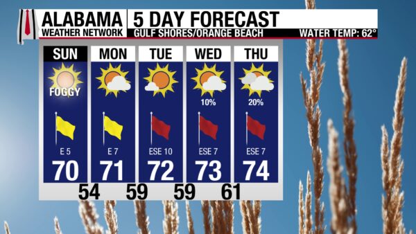
Today will be an even better day to soak up the sunshine than yesterday. The high will be in the low 70s, winds are from the east around 5 mph, and skies are clear leading to a high UV Index. Waters are calm with a low risk for rip currents and surf height around one to two feet. Enjoy a dip in the cool waters while you can, because the rip current risk is expected to increase later this week.

WEATHERBRAINS 1050
Tomorrow’s WeatherBrains episode features three guest speakers. Dr. Robin Tanamachi and Lindsey Peterson will discuss Purdue’s meteorology program, and Dr. Beth Hall brings updates from the Indiana State Climatologist office. Watch the episode here or listen wherever you get your podcasts.

TODAY IN WEATHER HISTORY
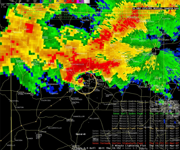
March 1, 2007 – The Enterprise Tornado
March 1, 2007, is a familiar and sober date for many Alabamians, as it marks the tragic day that nine people died in a strong EF4 tornado that hit Enterprise, AL. It also serves as the defining tornado of a larger severe weather outbreak across the Southeast that took place from February 28th through March 2nd. At 12:47 p.m. CST, the National Weather Service issued a tornado warning with a Particularly Dangerous Situation (PDS) tag for Coffee County. The timely warning helped citizens prepare, but the twister still wrecked immense damage. At 1:05 p.m., the powerful tornado touched down at the Enterprise Municipal Airport, damaged homes, and destroyed four chicken houses. 5 minutes later, the tornado slammed into Enterprise High School, where students were huddled up against the hallway walls. Winds of up to 170 mph tore into the school, collapsing a concrete wall that fell on and killed eight teenagers. The football stadium was destroyed, vehicles were tossed, and the surrounding area was left in ruins. Then, in downtown Enterprise, 83-year-old Edna Hays Strickland was killed when flying glass in her living room struck her. Along with nine tragic deaths, fifty people were injured. 1,100 homes were damaged or destroyed, and damages in the city exceeded $307 million. The tornado outbreak overall was responsible for 20 deaths and $580 million in damage, making it the fourth-costliest tornado outbreak in U.S. history at the time. The storm became the emotional and symbolic center of the larger tornado outbreak that left 20 dead across the South, as it was Enterprise that bore the heaviest heartbreak.

IMAGE OF THE DAY
Skywatcher Clay Hunsecker sent in a beautiful photo of the sunset in Huntsville last night.



