


Daily Weather Briefing
Sunday, May 3, 2026
ALABAMA THIS MORNING
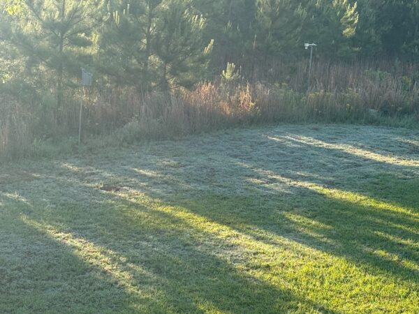
This morning is a chilly one across the state as clear skies and light winds let temperatures plummet last night. These clear and calm conditions persist this morning, as not a single cloud is seen in the sky. Temperatures now sit in the upper 40s to lower 50s in the north, and the low to mid 50s in central and south Alabama. Some Skywatchers were even reporting frost as some lows were reaching into the upper 30s. Skywatcher Lee Wiginton reported a low of 38 degrees and sent in this picture of frost on shaded grass.
ALABAMA 7 DAY FORECAST
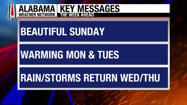
Today will be a quiet early May day, and dry and quiet conditions will persist through Tuesday afternoon. This is due to a surface high-pressure system sitting over the Southeast. Then a cold front will bring showers and thunderstorms to the state Wednesday through Wednesday night. There is a low-end severe threat with the system. Showers linger on Thursday, then dry conditions prevail once again through Saturday.
DRY TODAY THROUGH TUESDAY
The surface high-pressure will keep conditions dry over the beginning of this week.
After a chilly morning, today’s highs will rebound back into the upper 60s and lower 70s in the northern half of the state and the lower 70s to mid 70s in the southern half. Skies will be bright and cloud-free statewide, and winds will be light at 3-10 mph. A few locations in central Alabama could see wind gusts up to 15 mph, but they will be of no concern.
The surface high-pressure will shift east by tomorrow, encouraging southerly winds and therefore warmer temperatures and moister air. Highs will reach the upper 70s and lower 80s across Alabama Monday, and skies may be partly cloudy at times. We will continue to remain rain-free.
Tuesday will be quite similar to Monday, with highs ranging from the upper 70s north to the upper 70s and lower 80s centrally and in the south. Partly cloudy skies are expected once again. A light shower may fall in the north ahead of Wednesday’s system, but confidence is low, and the rest of the state will be dry.
COLD FRONT AND STORMS WEDNESDAY
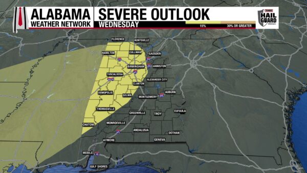
By around 7 a.m. CDT Wednesday morning, the cold front will be close to entering the northwest corner of the state. Throughout the day, the front will traverse southeastward, bringing showers and thunderstorms with it. North Alabama can expect rain essentially all day, while central Alabama is not expecting showers to start until the afternoon, and south Alabama waits until Wednesday night. More specific timing will be available closer to Wednesday. The front also brings a low severe weather threat for the south of Florence to slightly south of Chatom, through just west of Birmingham. There is a 15% chance of severe weather in this area Wednesday as plenty of shear is available with the system. Instability is the limiting factor right now, as it may be lower than expected if storms come through later than expected. If storms do become severe, the main concerns are damaging winds and the potential for isolated tornadoes. We will continue to watch the forecast here at AWN to bring you the most up-to-date information about this system. Highs will hit the upper 70s and lower 80s in the north, the low to mid 80s centrally, and the mid 80s in the south.
LINGERING RAIN THURSDAY
Showers will linger through Thursday, especially in the south. The northern half of the state features a 50% chance of thunderstorms, while the southern half features an 80% chance. There is no severe weather expected with these storms. Highs will start to cool behind the front, and only make it to the lower 70s north, the mid 70s in central Alabama, and the upper 70s and lower 80s in the south.
DRIER FRIDAY AND SATURDAY
Very low rain chances stick around in the forecast Friday and Saturday, so both days will be mostly dry.
Friday’s highs will sit in the mid 70s in the northern half of Alabama and the mid to upper 70s in the southern half.
Highs on Saturday will increase to the upper 70s north, lower 80s centrally, and the mid 80s south.
BETTER BEACH CONDITIONS BEGIN TODAY
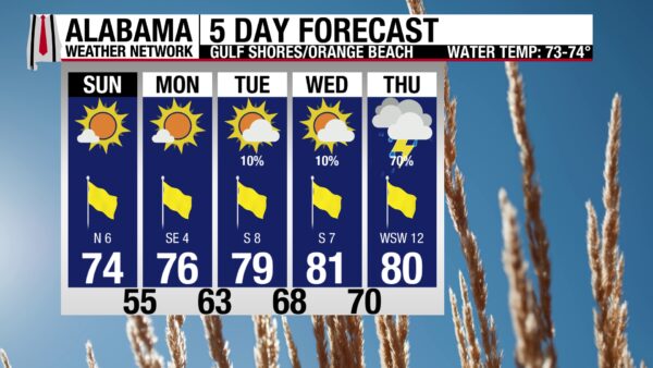
After a stretch of not-so-great beach weather, a pattern of dry and warm conditions begins today. The high will be in the mid 70s, skies will be sunny, leading to a Very High UV Index, and winds will be light at 5 mph. The water has calmed as well, with today featuring a Low rip current risk and a surf height of around 1 foot. The water temperature is in the lower 70s. Tomorrow will be warmer and water-wise.
WEATHERBRAINS 1059
Tomorrow’s WeatherBrains topic is: heat! The team will bring in special guests Jan Null, CCM, and Jackson Quinn from the University of South Alabama to bring in their unique perspective on heat and to talk about all things heat and heat safety related. Catch the episode wherever you get your podcasts or watch here.
TODAY IN WEATHER HISTORY
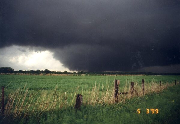
May 3, 1999 – Oklahoma Tornado Outbreak of ‘99
On May 3, 1999, one of the most destructive tornado outbreaks in modern U.S. history struck the central Plains, producing 76 tornadoes across Oklahoma and Kansas and causing widespread devastation. The most damaging tornado was a violent F5 that moved through the Oklahoma City metropolitan area, including the suburbs of Moore, Del City, and Midwest City, becoming the costliest tornado in United States history at the time with approximately $1.2 billion in damage. It is also called the Bridge Creek-Moore tornado. The tornado reached nearly one mile in width at its largest and produced catastrophic destruction, destroying more than 1,700 homes and businesses across the region. A mobile Doppler radar recorded a wind speed of 318 mph near Moore; the highest wind speed ever measured in a tornado. The tornado killed 36, ranking it at number six in the list of the top ten deadliest tornadoes in Oklahoma. In total, 43 people were killed, and about 680 were injured during the outbreak, while additional tornadoes caused fatalities and damage in Kansas, including five deaths and around 100 injuries in the Wichita metropolitan area. The event also highlighted safety concerns, as several people were killed after seeking shelter beneath highway overpasses, reinforcing guidance that bridges do not provide safe protection from tornadoes. The outbreak marked the first time an F5 tornado struck a major metropolitan area and remains a defining case study for emergency management, warning dissemination, and public tornado safety practices. The safest thing is to avoid the storm altogether. If the storm is close, the best thing to do is to abandon your automobile and seek shelter in a building on the lowest floor in an interior room without windows. If no shelter is available, find a ditch or low spot and cover your head.

IMAGE OF THE DAY
Skywatcher Lucretia Wyatt enjoyed yesterday’s beautiful day outside at Llama Palooza at Redbird Willow Farm in Anniston. How cute are these llamas!



