


Daily Weather Briefing
Sunday, May 10, 2026
ALABAMA THIS MORNING
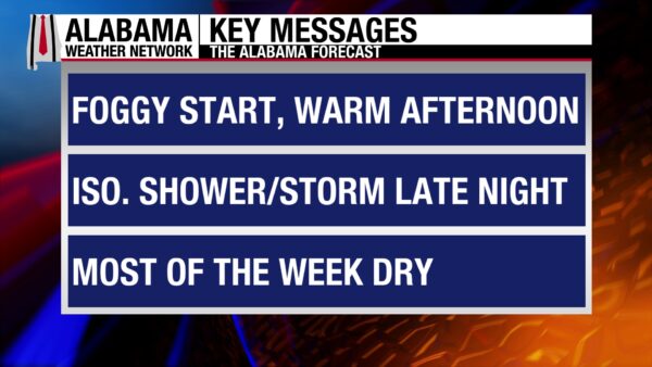
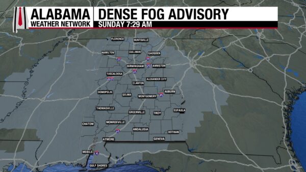
It’s a foggy Mother’s Day morning in Alabama. The entire state is under a Dense Fog Advisory until 9 a.m. CDT. As you head to church, run Sunday morning errands, and celebrate mothers, ensure extra caution is being exercised on the road. Winds are light, so fog will rely mostly on sunshine to cause it to dissipate, which will lead to patchy dense fog lingering past 9 a.m., especially in shady areas. Temperatures sit in the low to mid 60s statewide.
ALABAMA 7 DAY FORECAST
Today will feature a low chance of thunderstorms this afternoon. A weak cold front will push through the state today through tomorrow afternoon and bring a low chance of severe weather to parts of the south Monday. Past Monday, high pressure will develop in the Southeast, leading to dry conditions throughout the rest of the week. A dry cold front will pass through Alabama Wednesday into Thursday, but it will be hard to notice physically.
GOOD MOTHER’S DAY WEATHER
Your Mother’s Day plans will most likely not be ruined by the weather today. Skies will teeter between mostly to partly cloudy across Alabama, with a very low chance of isolated showers and thunderstorms in the northern half of the state this afternoon. That chance increases slightly in the southern half of the state, but any precipitation will be quick in nature, and any outdoor activities should be able to resume quickly. It will be fairly warm today, with highs in the low to mid 80s statewide.
THUNDERSTORMS TONIGHT
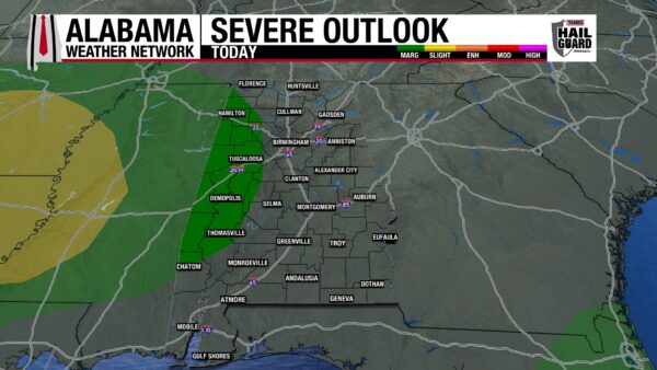
Thunderstorm chances increase tonight as the cold front moves toward central Alabama. A cluster of showers and thunderstorms will move over west-central Alabama in the late evening/early morning hours. The area is under a Marginal Risk (1/5) of Severe Thunderstorms, with damaging winds and hail expected to be the main threat. Some sub-severe thunderstorms will impact north Alabama, while much of south Alabama will stay dry. Lows will fall to the upper 50s and lower 60s north, and the low to mid 60s over central and south Alabama.
ANOTHER DAY OF SOUTHERN STORMS MONDAY
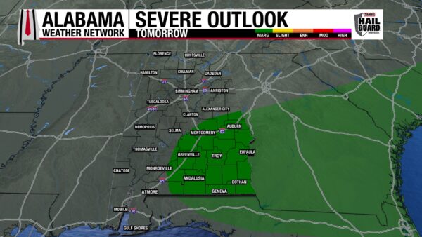
As the cold front continues southward on Monday, showers and thunderstorms will move over the southern half of the state. They carry a Marginal Risk (1/5) of Severe Thunderstorms, with damaging winds and hail possible. The northern half of the state will see shower chances in the morning dissipate quickly by the afternoon. Clouds will still spread across the entire state, and highs will range from the mid to upper 70s north and the lower 80s centrally and in the south. A 79-degree reading or two could infiltrate south-central west Alabama.
DRY PATTERN RETURNS TUESDAY
High-pressure moves into the South Tuesday, bringing mostly clear skies and dry conditions to Alabama. Highs on Tuesday will sit in the upper 70s to lower 80s range.
DRY FRONT WEDNESDAY
Another cold front will push through the state Wednesday, but it will be dry, and the airmass behind it will not be particularly cold. Low 80s will stretch across the state.
Little will change from Wednesday to Thursday despite the front, and highs will reach the upper 70s to lower 80s across the state once again.
WARMING TREND FRIDAY THROUGH SATURDAY
Friday begins a warming trend as highs reach back into the low to mid 80s statewide.
Highs increase into the mid to upper 80s statewide Saturday, with a 90-degree reading in the south possible.
The state will remain rain-free through Saturday.
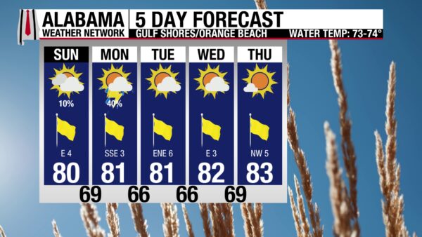
LOW RAIN CHANCE AT BEACH TODAY
After a stretch of stormy weather on the coast, we get a quick break today. There is only a 10% chance of showers and thunderstorms in the forecast today. Partly sunny skies lead to a Very High UV Index, the high will reach 80 degrees, and winds will be light at 5 mph from the East. Today’s waters are calm, and a Low rip current risk and surf height of one to two feet are expected. Tomorrow is the last day with a shower and thunderstorm chance in the forecast, then great beach weather will be the main story throughout the rest of the week.

WEATHERBRAINS 1060: STORIES FROM THE ROAD
Tomorrow’s WeatherBrains episode features special guest Charles Peek. He and the team will discuss his time as a professional storm chaser and field reporter for The Weather Channel and the stories and lessons from those experiences. Listen wherever you get your podcasts or watch here.

TODAY IN WEATHER HISTORY
May 10, 1910 – Weather Kite Record
A milestone in early meteorology occurred when the U.S. Weather Bureau flew a weather kite to 23,835 feet at Mount Weather, setting a record for upper-air observations. Before weather balloons, kites were used to lift instruments that measured temperature, pressure, and humidity high into the atmosphere. These observations helped scientists better understand conditions aloft and improve early forecasting, marking an important step in the evolution of modern weather observation.

IMAGE OF THE DAY
Skywatcher Tyne Wingo in Corner had a hard time watching the sunset in the sky last night because of a certain “attention-seeking” goat!

Happy Mother’s Day!



