


COOL START: Temperatures are in the 40s for parts of North and East Alabama early this morning… in fact we are seeing upper 40s as far south as Troy and Eufaula. But, with a dry airmass in place, expect a big warm-up today with highs in the low to mid 80s this afternoon as we enjoy sunshine in full supply.
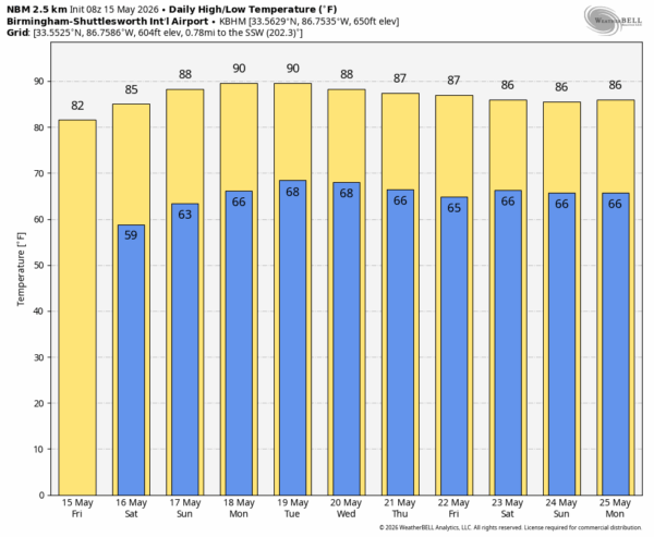
The weekend will stay dry with a warming trend. Highs will be in the mid 80s tomorrow, followed by upper 80s Sunday. Some communities will touch the 90 degree mark Sunday afternoon.
NEXT WEEK: Humidity levels will creep up Monday and Tuesday with afternoon highs near or just over 90 degrees… a summer feel. Any showers on these two days will be few and far between. Global models suggest the upper ridge could weaken slightly Wednesday, allowing a cold front to approach. If this is the case, then we will have a decent chance of showers and thunderstorms over the northern half of the state. Then, only isolated showers Thursday and Friday as the front washes out. South Alabama will most likely stay dry through the week… See the video briefing for maps, graphics, and more details.
ON THIS DATE IN 1968: A significant and deadly tornado outbreak struck most of the central and southern U.S. Producing 46 tornadoes, the outbreak killed at least 72 people, including 45 in Arkansas alone. The outbreak also produced two tornadoes in Iowa that were rated F5 on the Fujita scale. It was one of the deadliest tornado outbreaks in the United States since the 1960s and is one of the deadliest outbreaks in Iowa history.
Look for the next video briefing here by 3:00 this afternoon… enjoy the day!



