


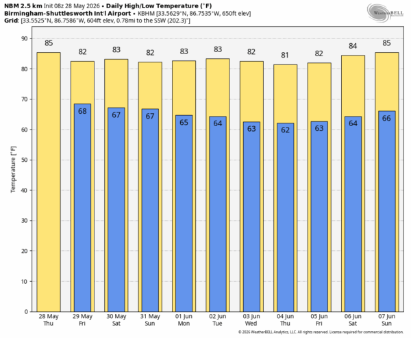
A FEW SHOWERS LATER TODAY: Very little rain across Alabama early this morning, but a few spotty showers and thunderstorms will develop this afternoon in the tropical air across the Deep South. The air aloft today is a little warmer, and this should mean showers will be fewer in number. Chance of any one spot seeing rain today is less than 50 percent; afternoon highs rise into the mid 80s.
Tomorrow the air aloft will be a little colder, meaning higher instability levels. Which, in turn, means there should be a higher coverage of scattered afternoon and evening showers and storms. Still, not raining everywhere. Most of the showers and storms tomorrow will come from noon to midnight.
THE WEEKEND: The overall pattern won’t change much. Warm, humid days with a mix of sun and clouds. Scattered showers and storms will be around both days, mostly during the afternoon and evening hours. No wash-out, but be ready for a passing shower or storm. Highs will be generally in the low to mid 80s.
NEXT WEEK: An upper ridge will build across the Deep South, meaning a drier pattern for the first half of the week. Showers will be hard to find Monday through Wednesday. Globals do show another surge of tropical moisture into the region late in the week and over the following weekend (June 6-7), meaning an increase in the number of showers and thunderstorms again. See the video briefing for maps, graphics, and more details.
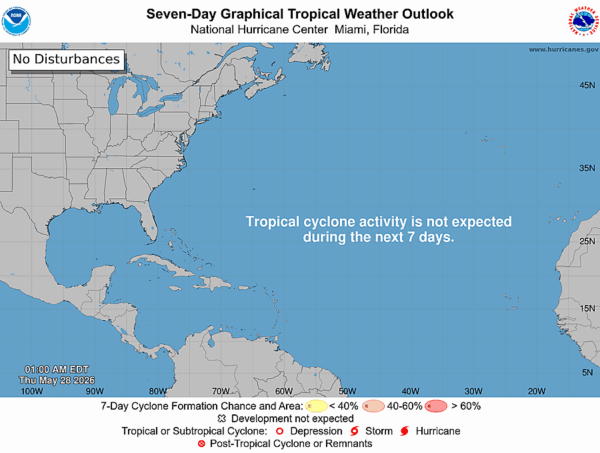
TROPICS: The Atlantic basin hurricane begins Monday. Tropical storm formation is not expected for at least the next seven days.
ON THIS DATE IN 2019: Two tornadoes, rated EF-2 and EF-4, carved a continuous 39-mile path across Douglas and Leavenworth counties in Kansas, skirting the towns of Lawrence, Eudora, and Linwood–dissipating just before reaching the western Kansas City metro.
Look for the next video briefing here by 3:00 this afternoon…



