


Daily Weather Briefing
Monday, June 15, 2026
ALABAMA THIS MORNING
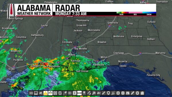
Most of Alabama wakes to a quiet morning, except for the coast. Showers and thunderstorms stretch as far north as Citronelle. A few very light showers dot Covington, Butler, and Crenshaw Counties as well. Otherwise, clouds stretch across the southern two-thirds, and north Alabama sees clear skies after the cold frontal passage yesterday. Temperatures range from the upper 60s and lower 70s north to the low to mid 70s centrally and in the south. Southwest Alabama has a head start as they sit in the upper 70s already.
ALABAMA 7 DAY FORECAST
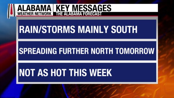
The story this week is rain and potential for flooding, especially in the southern two-thirds of Alabama. Yesterday’s front has stalled over central Alabama and will remain there through Wednesday, interacting with short wave pulses and the upper-level trough. This is a recipe for multiple days of rain across the region. South Alabama will see multiple days of rain as well due to that trough and the tropical low that will weaken but provide plenty of moisture to the region this week. North Alabama will be drier today and tomorrow, but rain chances uptick quickly as that low and another cold front from the northwest nears later this week.
DOWNPOURS BEGIN TODAY
We really begin to get into the weeds of the wet pattern today, with the southern half of the state seeing most of the chance for showers and thunderstorms. This is due to that stalled front over central Alabama keeping moisture contained in south-central and south Alabama. North and north-central Alabama will be mostly dry today since that front pushed through, and drier and cooler air sits over the region. Skies will be cloudy. Highs will rise to the upper 70s to lower 80s through the northern half of the state. The northernmost part of southwest Alabama (Demopolis, Selma, Thomasville) will also only reach the upper 70s and lower 80s, while the rest of the south will rise to the mid 80s to low 90s.
SOME SHOWERS LINGER TONIGHT
Showers will linger in the southern half of the state tonight while the northern half of the state will not see rain until early tomorrow morning. Lows will fall to the lower 60s north, the mid 60s to around 70s degrees centrally, and the low 70s south.
RAIN SPREADS ACROSS ALABAMA TOMORROW
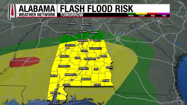
The northern half of Alabama will not be dry for long as shower and thunderstorm chances increase to 20%. Rain in north Alabama is expected in the morning, then the rain trend should shift toward central and south Alabama throughout the day. Thunderstorms will be widespread, and flash flooding will be a concern. Highs will sit in the upper 70s and lower 80s statewide.
SLIGHT BREAK WEDNESDAY
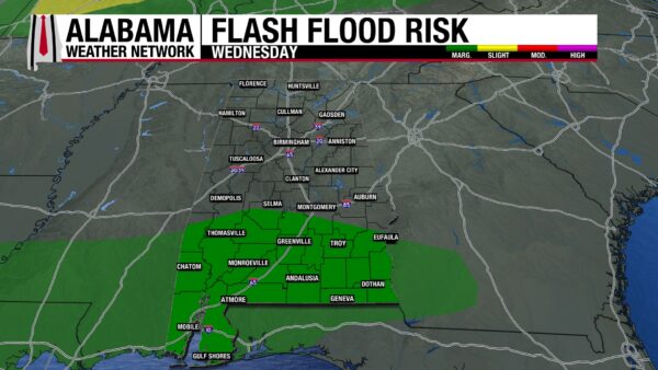
The broad showers and thunderstorms should become less overarching on Wednesday, with rain focusing mostly on south Alabama. North and central Alabama may see a few showers and thunderstorms, but much less compared to Tuesday. Cloud cover is expected regardless of rain. Highs will climb into the mid 80s across the state.
WIDESPREAD RAIN RETURNS THURSDAY
As the area of low pressure moves toward the state from the west and a cold front moves from the north/northwest, moisture in the atmosphere will increase, and widespread showers and thunderstorms are anticipated. They are expected to produce heavy downpours. Highs will return to hot as they reach the upper 80s over Alabama, with a 90-degree reading possible in the south.
EXPANSIVE RAINFALL CONTINUES FRIDAY
This large-scale rainfall pattern will continue Friday, keeping our flash flood concerns elevated. Highs will decrease compared to Thursday and range from the lower to mid 80s in the northern half of the state to the mid to upper 80s in the southern half. A 90-degree high is still attainable in the southeast.
POSSIBLY DRIER THIS WEEKEND
As of right now, this weekend is trending drier compared to the week. Rain chances decrease to 30% in the northern half and 50% in the southern half of the state on Saturday, then a 30% chance stretches over Alabama Sunday. Highs will sit in the mid 80s over most of the state on Saturday, then hit the upper 80s Sunday.
RAINFALL OUTLOOK
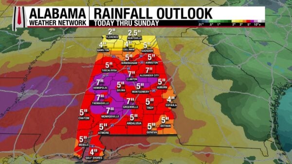
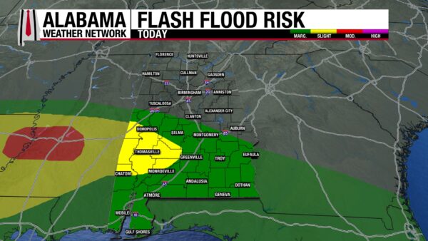
Over this week, Alabama will see anywhere from 2” of rain to up to 7” of rain. As you can see, a very large portion of Alabama, from north-central Alabama through the south, will see 5-7″. This raises multiple, back-to-back days of a Marginal to Slight Flash Flood Risk across Alabama. Through Friday, some portion of the state will be under a low to medium level of concern about flash flooding. Especially toward Thursday and Friday, a Slight Risk almost engulfs the state. We will really be emphasizing the importance of being careful on the roads this week. Turn Around, Don’t Drown!
ALL EYES ON THE GULF
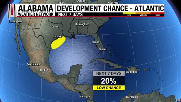
The area of low-pressure over northeast Mexico will bring rain and flooding to Texas and Louisiana this week. It then may reemerge over the northwestern Gulf later this, where it will have a 30% chance of development. Regardless of if it becomes a tropical system, it will be responsible for multiple days of rain and flooding across the Southeast this week.
RAINIER DAY ON THE COAST
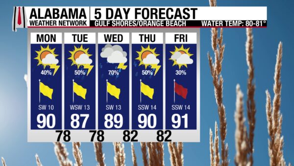
After a weekend of very pleasant beach weather, rain and thunderstorms dominate the coast this week. Today, showers and thunderstorms fall throughout the morning. This afternoon should see a break in the rain and clouds, but by early evening/dinner time, more rain will come through the area. Hopefully beachgoers are able to soak up the few less rainy hours at the beach. Highs will be in the mid 80s, skies will be partly cloudy, and winds are from the west at 10 mph. Additionally, there is a Moderate risk of rip currents today, forecasted to get stronger by the end of the week. Thunderstorms are expected to increase coverage each day this week.

WEATHERBRAINS 1065
The WeatherBrains episode from Thursday will be released on listening platforms and the WeatherBrains website Tuesday morning.
TODAY IN WEATHER HISTORY
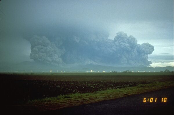
June 15, 1991 – When Disasters Meet
On June 15, 1991, Mount Pinatubo in the Philippines exploded with a force that sent ash and volcanic debris more than 100,000 feet into the sky. The climactic eruption was one of the most powerful volcanic events of the twentieth century, blasting material into the stratosphere and turning daylight into darkness across parts of central Luzon. Pyroclastic flows of hot gas, ash, and pumice raced down the slopes, filling valleys and burying the landscape beneath fresh volcanic deposits.
The disaster was made even worse by the weather. As Pinatubo erupted, Typhoon Yunya was passing across the region, bringing heavy rain and strong winds. The rain mixed with falling ash and turned it into a thick, heavy, concrete-like substance that coated roofs, roads, vehicles, and evacuation areas. Many deaths occurred when ash-loaded roofs collapsed under the tremendous weight, trapping people who had already fled the volcano’s most dangerous slopes.
The human toll was severe. About 847 people died, and more than 200,000 were left homeless as communities across central Luzon were damaged or buried. Thousands of Indigenous Aeta residents who had lived near the volcano were displaced from ancestral lands. Clark Air Base and Subic Bay Naval Station were heavily damaged, and the region faced a long recovery as ash, mud, and debris disrupted transportation, agriculture, water supplies, and daily life.
Pinatubo’s effects did not end when the eruption column collapsed. Heavy rains in the months and years that followed repeatedly remobilized the loose ash into lahars, fast-moving volcanic mudflows that buried villages, roads, bridges, and farmland. Each typhoon or monsoon rain brought renewed danger, showing that a volcanic eruption can remain a weather-driven disaster long after the main explosion is over.
The eruption also reached the global atmosphere. Massive amounts of sulfur dioxide entered the stratosphere, spreading around the world as sulfate aerosols that reflected sunlight back into space. Global temperatures cooled by about 1 degree Fahrenheit for a time, making Pinatubo not only a Philippine disaster, but a worldwide climate event. It remains one of the clearest examples of how geology and weather can collide, turning a local eruption into a global atmospheric story.

IMAGE OF THE DAY
Our newest meteorologist Sadie Morris has had wonderful luck with rainbows this weekend! She took this wonderful photo of a double rainbow in Birmingham last night.



