


Daily Weather Briefing
Thursday, June 18, 2026
ALABAMA THIS MORNING
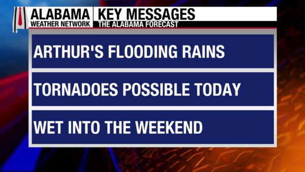
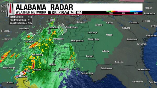
The remnants of Tropical Storm Arthur enter southwest and west Alabama now, with showers and thunderstorms stretching from south of Fayette to Dauphin Island and west toward Andalusia. A Special Weather Statement is effect in Tuscaloosa, Hale, Pickens, and Greene Counties until 6:30 a.m. as a strong thunderstorm moves through the area. An Areal Flood Watch is in effect over the southern two-thirds of Alabama throughout Friday as we prep for two days of a lot of rain. The rest of central Alabama is dry for now, but clouds make for a gloomy morning. Clouds make north Alabama’s morning cloudy as well, but sunshine is able to peak through multiple breaks in the clouds. Temperatures sit in the very warm upper 70s statewide. The coast is stuck in the low 80s. Not only is it a warm morning, but it’s a humid one as well, with dew points sitting in the mid to upper 70s. It certainly feels like it’ll be a stormy day in the state.
ALABAMA 7 DAY FORECAST
Be weather aware today as the remnants of Tropical Storm Arthur bring heavy rainfall, strong winds, and a low tornado threat to the state. Tomorrow, a cold front will meander its way through north and central Alabama, keeping rain, flood, and severe weather chances elevated across Alabama. Saturday will bring a slightly drier pattern to the northern half of the state, while south Alabama stays wet. Sunday the pattern flips as a more zonal flow takes place and the frontal boundary lifts north, bringing higher rain chances to north Alabama and gives south Alabama the break. Another front will move through Alabama Monday through Wednesday, and rain chances will stay relatively elevated in the northern half of the state while the southern half of the state sees less rain chance.
REMNANTS OF ARTHUR IMPACT ALABAMA TODAY
Regardless of geography, the entire state will experience some sort of impact from the remnants of Tropical Storm Arthur today. Below, the impacts are broken up by North, Central, and South Alabama.
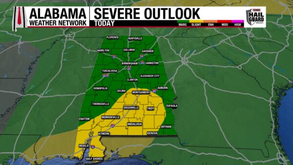
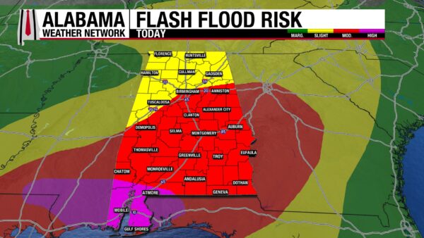
North Alabama: Heavy rains and strong winds are the main concerns with Arthur today. Rain will begin any time between 8 and 10 a.m. CDT this morning and continue throughout the day. Northwest Alabama could see rain clear out as early as 2 p.m. today, and the low-pressure moves south of the region. A Marginal Risk (1/5) for Severe Thunderstorms stretches across the region, with damaging winds the main concern with storms. While the tornado risk should stay south, it’s important to expect the unexpected. While rainfall is going to be less compared to the rest of the state, north Alabama is still saturated, and it won’t take much rain to cause flash flooding to occur, so the Weather Prediction Center has placed the north under a Slight Risk (2/4) for Excessive Rainfall/Flash Flooding. Highs will rise to the upper 70s to mid 80s, the lower range of these temperatures expected toward the southern portions of the region such as Hamilton, Cullman, and Gadsden, while the higher range extends into areas like and near Florence and Huntsville.
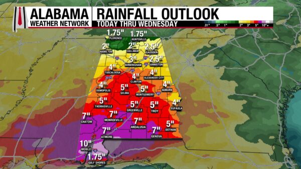
Central Alabama: Showers and thunderstorms could begin in the area by 6 a.m. in the southwest corner of the region and by 8-10 a.m. in the northeast corner. Concerns today include heavy rainfall, flooding, and marginally to slight severe thunderstorms. North-central and northwest-central Alabama sits under a Slight Risk (2/4) for Flash Flooding today, while the rest of the region is under a Moderate Risk (3/4). Rainfall amounts of 1.5” to 2.5” are possible, with locally higher amounts possible. Additionally, the Storm Prediction Center has placed most of the region under a Marginal Risk (1/5) for Severe Thunderstorms today, while the parts of south-central (Montgomery, Troy) Alabama sit under a Slight Risk (2/5). Severe thunderstorms could develop and bring damaging winds and spin-up tornadoes to the region. The Slight Risk means those regions are more likely to see these impacts. Highs will reach the upper 70s and lower 80s.
South Alabama: This is the area that causes the most concern. The region is expecting marginal to slight severe weather, heavy rains and flooding, as well as coastal flooding. Highs will sit in the upper 70s and lower 80s.
Severe weather: parts of southwest and southeast Alabama are under a Marginal Risk (1/5) of Severe Thunderstorms today, while Mobile, Baldwin, Escambia, Monroe, Conecuh, Covington, Coffee, Butler, Lowndes, Crenshaw, Montgomery, and parts of Geneva, Dale, Barbour, Bullock, Clarke, Wilcox, Dallas, Autauga, Elmore, and Macon sit under a Slight Risk (2/5). Strong winds and spin-up tornadoes are possible in these areas, with a higher chance for the Slight Risk areas.
Flooding: It is rare that any parts of Alabama see this High Risk (4/4) for Flash Flooding but today is one of those rare days. Southwest and coastal Alabama are under this outlook today, while the rest of the south is under a Moderate Risk (3/4). Anywhere from 5 to 10” of rain could fall across the region, with locally higher amounts of 12 to 15” expected in Mobile and Baldwin Counties. This is already an incredibly impressive amount of rain, and when you factor in how wet the south has been, especially the southwest, it is easy to understand the flood concern in the region. The Mobile NWS Office Considerable Flash Flooding is likely, and Catastrophic Flash Flooding is possible. This flash flooding could be life-threatening.
Coastal Flooding: Coastal flooding in Mobile Bay is possible today with high surf and copious rainfall amounts.
Takeaways for today: Be weather aware! Have multiple ways to receive watches and warnings and be extra careful if you have to travel today. If you can avoid travelling- do so. Also, review your severe weather plan and flood plan. Have a backup severe weather plan for if your safe space is taking on water, especially if you’re in the south! We are already here at the Alabama Weather Network ready to go live whenever warnings begin.
FRONTAL PASSAGE KEEPS ALABAMA WET TOMORROW
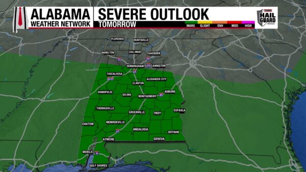
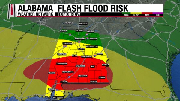
Unfortunately, tomorrow will still be wet across Alabama as a cold front is expected to move across north and central Alabama. This will bring rain and thunderstorms to these regions and keep tropical moisture trapped in the south. With the continued rain chance, a Marginal to Moderate Risk (¼-3/4) for Flash Flooding extend from north-central Alabama to the south. A quarter of an inch to an inch and three-quarters of rain is expected to accumulate. On top of the rain, we will get today- that’s dangerous. Another Marginal Risk (1/5) for Severe Weather will be in place across the southern two-thirds of the state with damaging winds the main concern. Highs will hit the mid 80s statewide, with southwest Alabama trying to climb into the upper 80s and lower 90s.
BREAK FROM RAIN SATURDAY IN THE NORTH, STAYS RAINY SOUTH
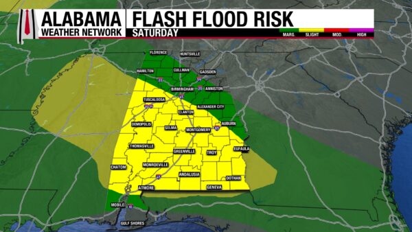
The front will bring drier air into north and central Alabama on Saturday with the region only anticipating isolated to scattered showers. The southern half of the state, however, will see yet another day of widespread showers and thunderstorms. Luckily, we will see the end of the severe weather threat for the rest of the forecast period. However, we will not see the end of the flood risk, with western north-central, south-central and south Alabama seeing a Slight Risk (2/4) for Flash Flooding. A Marginal Risk (1/4) stretches over much of northwest, central and eastern central Alabama as well as the coast. Highs will hit the mid 80s over the state with the upper 80s possible in the south.
WETTER NORTH, DRIER SOUTH FOR FATHER’S DAY
The pattern flips on Sunday, and the northern half of the state will be wet, while the southern half of the state will be drier. This is due to a short wave that will push through the north, and widespread showers and thunderstorms will impact the region. The south will see some scattered showers, and it will be a much-welcomed break from the constant rain we will have seen. Highs will begin to climb into upper 80s statewide.
RAIN CONTINUES NORTH NEXT WEEK
Another day of widespread showers is expected in the northern half of the state while the southern half of the state sees only a 10% chance of showers. That is certainly much needed in the region. Highs will range from the upper 80s north to the low 90s centrally and in the south. Humidity will be high, and we’ll be watching the heat risk in the south as feels-like temperatures rise to the mid to upper 90s.
RAIN DROPPING OFF MID WEEK
Rain chances stick to less than 50% statewide through Tuesday and Wednesday as we enter a typical summer-like shower pattern. Highs will hit the mid 80s from north through south-central Alabama and the low 90s south on Tuesday and Wednesday.
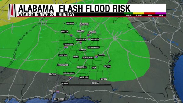
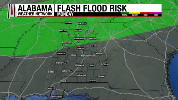
RAINFALL OUTLOOK
Over the next 7 days, Alabama could receive 1.75 to 10” of rain, with locally higher amounts possible, and the majority of this rain falling today and tomorrow. Although mentioned above, the Flash Flood Risk graphics have been placed in this section. It is worth talking about the Excessive Rainfall outlook Sunday as well. A Marginal Risk extends from north to south-central Alabama as the very wet soil will have a low threshold for how much water it can handle. Please remember Turn Around, Don’t Drown. Consider your flood plan this morning and be prepared to carry it out over the next few days.
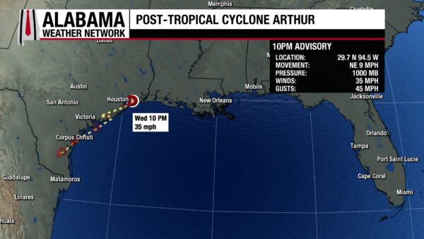
ARTHUR DOWNGRADED
The remnants of Tropical Storm Arthur have already made their way to west Alabama. At its last advisory, winds were sustained at 35 mph. Heavy rain stretches from Ville Platte, MS to Andalusia, AL this morning. They are expected to continue to move across the state today and into Georgia by this evening.
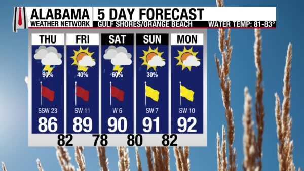
OUT OF THE WATERS TODAY
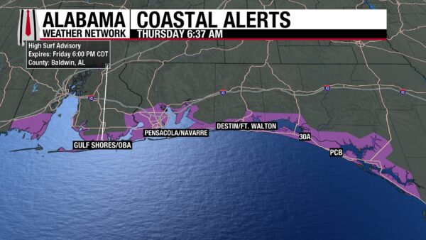
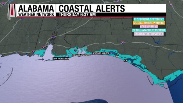
Today is an inside day on the coast. The remnants of Tropical Storm Arthur will bring heavy rain, flooding, and a low severe weather threat. The high will be in the mid 80s, and winds will be from the southwest at 25 mph, often gusting much stronger. There is a High rip current risk and a High Surf Advisory in effect through Friday. Surf heights will reach 5 to 7 feet, and the ocean will be very dangerous. It is strongly advised that no one enters the water today. Movies and board games should certainly be your plan if you’re at the beach today and tomorrow. Tomorrow and Saturday will be icky as well.

TODAY IN WEATHER HISTORY
June 18, 1815 – The Mud of Waterloo
The Battle of Waterloo is usually remembered through the names of the commanders: Napoleon, Wellington, and Blücher. But in the days before the decisive battle on June 18, 1815, the atmosphere over Belgium became part of the campaign itself. A shallow but active storm system moved across the region, bringing fronts, thunderstorms, and soaking rain at precisely the moment Napoleon needed speed, clear fields, and dependable firepower. On June 16, as Napoleon struck the Prussians at Ligny and Marshal Ney fought Wellington’s forces at Quatre Bras, thunderstorms complicated the battlefield. The French won at Ligny, but not cleanly enough. Rain made muskets difficult to use at critical points, and Napoleon failed to destroy the Prussians as a fighting force.
The next day may have been the true weather hinge of the campaign. Violent thunderstorms broke out again, and the rain turned roads, fields, and farm lanes into a quagmire. Wellington withdrew toward the ridge of Mont-Saint-Jean, south of Waterloo, while Napoleon’s army tried to pursue through mud. The French were slowed not only by the condition of the roads, but by the difficulty of moving men, horses, cannon, and ammunition across saturated ground. That night, thousands of soldiers bivouacked in miserable conditions as thunder rolled and heavy rain fell on the ground that would become the next day’s battlefield.
By the morning of June 18, the rain had ended, but the damage had been done. Napoleon wanted to attack early, but the ground was too soft for the kind of battle he wanted to fight. Artillery, one of his greatest advantages, needed firmer ground. Cavalry needed footing. Infantry needed to move in formation. Instead, the opening attack was delayed until late morning, with the French Grande Batterie opening around 11:20 a.m. and the first assaults falling against Hougoumont. Those lost hours became one of the most debated delays in military history.
For much of the afternoon, Napoleon still had a chance. French attacks battered Wellington’s line, Hougoumont burned, and La Haye Sainte eventually fell as the Allied center came under heavy pressure. But to the east, the Prussians were arriving. The army Napoleon had beaten at Ligny had not been eliminated, and the muddy delay helped give Blücher’s men time to reach the field. By evening, Prussian pressure at Plancenoit forced Napoleon to commit reserves, while Wellington’s battered line held long enough to repulse the Imperial Guard. Weather did not defeat Napoleon by itself, but the rain and mud changed the timing of the campaign. At Waterloo, the sky did not fire a musket or move a cannon, but it helped decide when those weapons could be used.
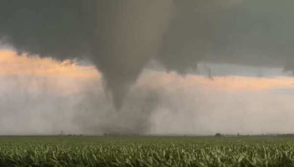
IMAGE OF THE DAY
Storm Chaser Brett Adair sent awesome photos of a tornado he intercepted in Effingham, Illinois yesterday.



