


Daily Weather Briefing
Saturday, June 20, 2026
ALABAMA THIS MORNING
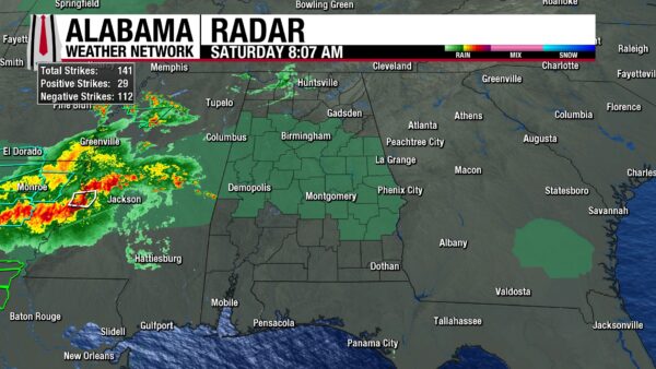
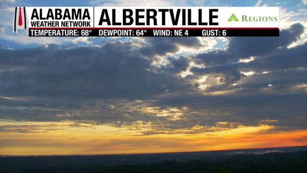
It’s a humid morning with temperatures in the low to mid 70s and dewpoints in the upper 60s north and low 70s in central and south Alabama. Some light showers stretch between Florence and Huntsville, while the rest of the state is dry and partly to mostly cloudy. The sunrise on the Albertville Regions Skycam was amazing!
ALABAMA’S 7 DAY FORECAST
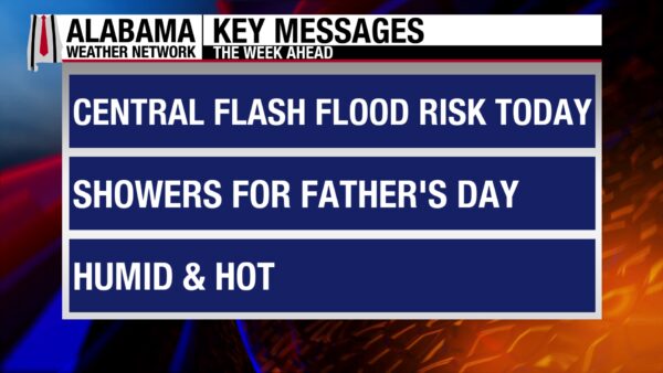
Another day of widespread showers and thunderstorms is anticipated across Alabama today as a stalled frontal boundary and a short wave allow for a large swath of storms to move through. Father’s Day looks to be a little less messy with a more scattered shower pattern expected statewide. Then a high-pressure and upper-level pattern tries to settle into south Alabama Monday, limiting rain chances south, while rain will move through the north easily.. A cold front will move into Alabama Tuesday and stall again over the north-central portion of the state. Rain sticks around for the end of the week as another trough will move over the region.
WET TODAY
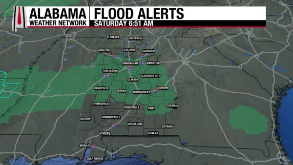
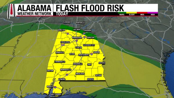
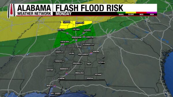
We’ll see a system of showers and thunderstorms move across Alabama today, with its focus on central and south Alabama. The north will see some rain, but not as much for as long as the southern two-thirds of the state is expecting. A Slight Risk (2/4) for Flash Flooding stretches from north-central to south Alabama today, while a sliver of the north is under a Marginal Risk. However, the most northern and northeastern parts of the state are not under any flash flood risk. Central Alabama is at the largest risk for flash flooding, so an Areal Flood Watch is effect in the region until 7 pm. CDT tonight. The good news is storms are not expected to be severe, but a few strong storms with lightning and heavy downpours will occur. Highs will be cooler than yesterday, only ranging from the low 80s north to the mid 80s south. Coastal Alabama is the exception with highs in the upper 80s possible.
SCATTERED SHOWERS FOR FATHER’S DAY
Afternoon scattered showers and thunderstorms are in the forecast for all of Alabama tomorrow, making for a potentially wet Father’s Day. Tomorrow is also the Summer Solstice. The longest day of the year and the first day of the summer season! Highs will be in the upper 80s from north to south-central Alabama and the upper 80s to lower 90s in the south. Typical summer weather for the first day of summer!
WETTER NORTH MONDAY
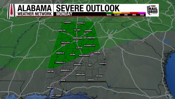
As mentioned above, an upper-level ridge will build into the south on Monday, keeping the higher rain chances north. Still, the air is very moisture isolated to scattered showers expected in the south. There is also a Marginal risk (1/5) of Severe Thunderstorms in the northern two-thirds of the state. Damaging winds will be the main concern. Highs in the 90s will spread further north into central Alabama, leaving the upper 80s to dominate the north.
FRONT TUESDAY
A front will attempt to push through the state on Tuesday, bringing more rain to the north. It will stall out, keeping the southern half of the state in a scattered shower pattern. Highs will be slightly cooler, topping out in the mid 80snorth, the mid to upper 80s centrally, and the low 90s south.
WET CONTINUES TO END THE WEEK
More upper-level short waves will progress toward and through Alabama Wednesday through Friday, keeping us wet and hot. Highs on Wednesday rise to the low 80s north to low 90s south. The range will shorten Tuesday, with mid to upper 80s expected. 90s return in the south on Friday while the north sticks to the mid 80s and central Alabama sees the upper 80s again.
RAINFALL OUTLOOK
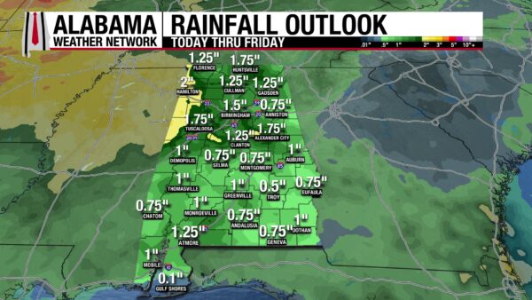
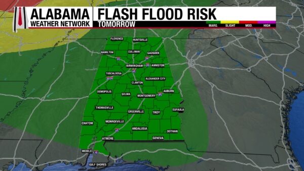
We are still stuck in this wet pattern, and Alabama will receive another 0.75 to 2” of rain over the next seven days. That is a lot less compared to what we saw this week, but it will not mitigate flash flood concerns. Soils are wet, and creeks and rivers are high, so it will not take a lot of rain to cause flash flooding. Today’s risk is outlined in the forecast above. Tomorrow, a Marginal Risk of Flash Flooding spreads over all of Alabama. Any flood concerns are contained in north and north-central Alabama on Monday, and the south will finally get their relief from the wet pattern. Tuesday sees a Marginal Risk for much of west Alabama.
NOT MUCH DROUGHT IMPROVEMENT
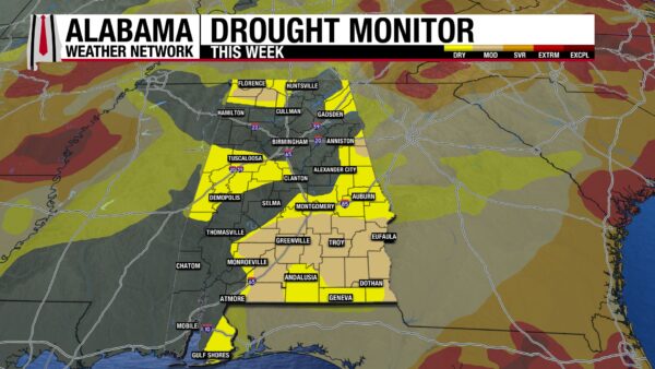
Despite quite a bit of rain across Alabama this week, the drought has improved little. The percentage of the state that is no longer in a drought has increased by 3% to about 48%. Otherwise, the Abnormally Dry and Moderate Drought areas in the state have seen a 1% decrease in coverage. Of course, we’re expecting this drought to be greatly impacted by yesterday’s rain, but we’ll have to wait until next Thursday to see its overall impact.
QUIET IN THE TROPICS
In both the Eastern Pacific and the Atlantic Hurricane Basins are quiet after an active few weeks.
STORMY WEEKEND ON THE COAST, WEATHER IMPROVES NEXT WEEK
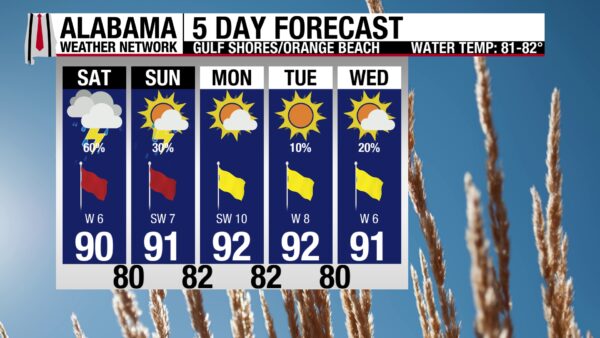
The coast is water-logged and ready for a pattern change. The good news is it’s on the way; the bad news is this weekend will still be wet. A 60% chance of thunderstorms is expected today. Luckily, it won’t be a complete washout, and skies will be partly sunny, and the IV Index will be high, at least for the first half of the day. The high will be around 90 degrees, and the winds will blow from the southwest at 10 mph. The rip current risk is still High and will continue tomorrow too. Rain chances dwindle to 30% tomorrow, then a drier week is ahead!
TODAY IN WEATHER HISTORY
June 20, 1957 – Funnels on Film
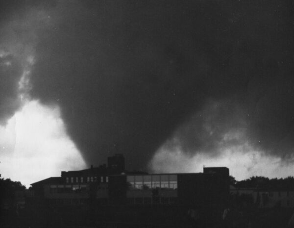
June 20, 1957, was the kind of muggy summer day that made people across the Red River Valley uneasy. Temperatures were in the 80s, dew points were in the middle and upper 60s, and a moist, unstable air mass was in place over eastern North Dakota and western Minnesota. At the Weather Bureau office in Fargo, Ray Jensen watched the western sky carefully. Forecast tools were primitive by modern standards, the observation network was sparse, and there was no conventional weather radar available for this storm. Much of the warning process depended on meteorological judgment, phone calls, and trained eyes looking out the window.
By early evening, towering clouds west and northwest of Fargo had grown into a severe thunderstorm complex. The parent storm would become what meteorologists today call a long-lived cyclic supercell, producing at least five tornadoes from North Dakota into Minnesota. The Fargo tornado was the most violent of the family. It later received an F5 rating, the highest level on the Fujita Scale, and carved a path through the north side of Fargo before crossing the Red River toward Moorhead, MN.
The warnings were unusually successful for the era. Severe thunderstorm and tornado information was relayed to local radio and television stations, and Weather Bureau personnel continued feeding updates as the storm approached. Jensen and others could see the dangerous storm structure with their own eyes: a rotating wall cloud, a tail cloud extending from it, and a turbulent collar cloud above. The sight was so visible and so dramatic that many people did take protective action or leave the path. Others, however, did something that terrifying. Instead of immediately taking cover, they went outside with cameras and home movie equipment to document the approaching tornado.
The tornado struck hardest in north Fargo, especially in the Golden Ridge area, where F5 damage occurred. Homes were swept from foundations, debris was thrown through the air, schools and churches were damaged, and neighborhoods were left unrecognizable. Official and historical death tolls vary, with many records listing 10 immediate deaths and more than 100 injuries, while later summaries sometimes include additional victims who died later from tornado-related injuries.
Yet from the devastation came one of the most important tornado studies in American meteorology. Dr. Tetsuya “Ted” Fujita of the University of Chicago analyzed roughly 200 photographs and films of the storm and its damage. The images allowed him to reconstruct the life cycle of the supercell and tornado in remarkable detail. His work showed that features such as the wall cloud, tail cloud, and collar cloud were not random shapes beneath a thunderstorm. They were visual evidence of powerful storm-scale processes that could help reveal what a tornadic supercell was doing.
That changed the language of storm spotting. The Fargo tornado helped Fujita build the foundation for later tornado damage research, including the Fujita Scale introduced in 1971. It also gave meteorologists and spotters a clearer vocabulary for reading the sky. The people who photographed the tornado may not have known they were documenting a turning point in weather science, but their images helped generations learn what a dangerous storm looks like before it becomes a disaster.
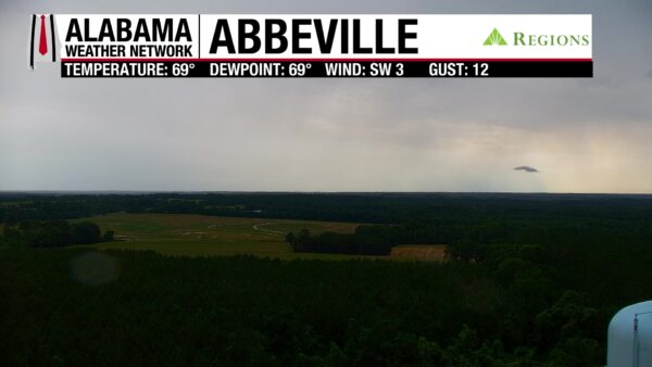

IMAGE(S) OF THE DAY
Our first Image of the Day is of Abby, a little cloud that formed in Abbeville yesterday afternoon. Thanks Bill and Sadie!
Our second image is from Skywatcher Vanessa Sanchez, who doesn’t just watch the sky for weather. She also spots beautiful butterflies!



