


PLEASANT START: Dry air is in place over North Alabama, and a few spots have dipped into the upper 50s early this morning with a clear sky and light wind. South Alabama is much warmer with temperatures in the low to mid 70s at daybreak. Expect a partly sunny sky today with a high between 85 and 92 degrees. Much of the state will be dry, however a band of strong storms will likely move into the southwest part of the state this afternoon. SPC has defined a “marginal risk” (level 1/5) of severe thunderstorms for Southwest Alabama…
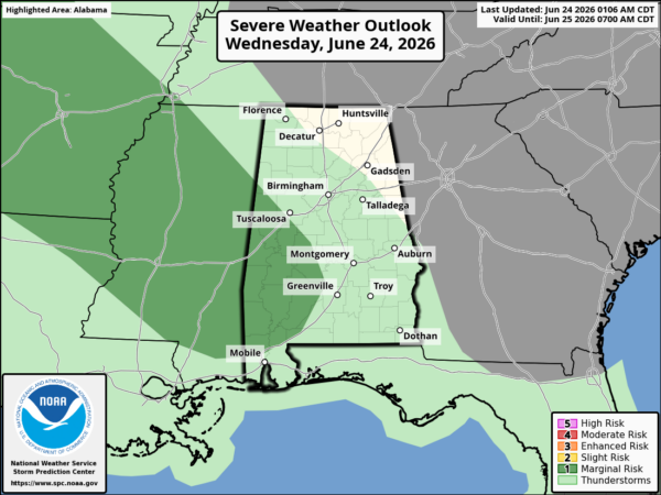
A few storms in this part of the state could produce strong, gusty winds generally between 2:00 and 7:00 p.m.
Tomorrow looks like a very typical late June day. Partly sunny with a few widely scattered showers and thunderstorms around during the afternoon and evening hours.
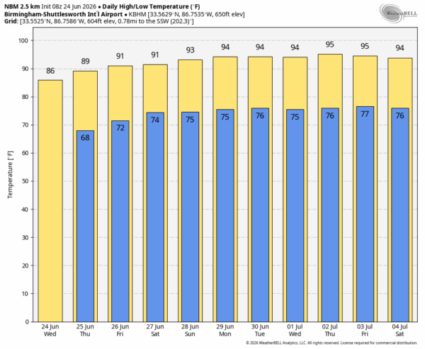
FRIDAY AND THE WEEKEND: An upper ridge will begin to build across the Deep South. This will bring hot and mostly dry weather to Alabama on these three days; afternoon highs will be in the low to mid 90s, and afternoon showers will be few and far between.
The overall pattern won’t change much next week and into the Fourth of July holiday weekend. The hottest weather so far this summer with mid 90s on most days and only small, isolated afternoon showers and storms. See the video briefing for maps, graphics, and more details.
TROPICS: All is quiet across the Atlantic basin; tropical storm formation is not expected for at least the next seven days.
ON THIS DATE IN 1957: A tropical depression formed on June 24, 1957, in the Bay of Campeche. It would ultimately become Hurricane Audrey, one of the most intense and deadliest June hurricanes in U.S. history. It underwent explosive intensification in the Gulf, pushing a catastrophic 12-to-14-foot storm surge miles inland across Cameron Parish, Louisiana, resulting in at least 416 fatalities.
Look for the next video briefing here by 3:00 this afternoon… enjoy the day!



