


Brian Peters will be along shortly with more details, but here are some early morning thoughts on today’s weather…
*As expected, the worst of the weather yesterday was to the west and north of Alabama… places like Nashville, Memphis, and Little Rock were hammered with flooding and severe storms; the day was calm for most of Alabama with the only problems coming over the northwest corner of the state. All in all, the day yesterday was actually pretty pleasant.
*Today’s severe weather parameters are not the same as what our friends to the west dealt with yesterday. Helicity values will be coming down, lapse rates are marginal, and the air becomes saturated through a large part of the atmosphere, which should mean heavy rain will be the greatest threat for Alabama later today and tonight. No doubt there could be a few severe thunderstorms, and we will need to monitor the situation closely, but the tornado probabilities are in the 5 percent range for any one given point, and SPC has a standard “slight” risk in effect today for much of north and west Alabama.
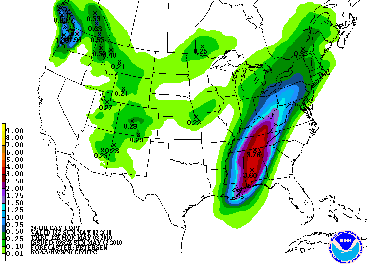
*Concerning the flood potential, the NAM is printing 1.31″ for Birmingham during the next 84 hours, while the GFS is wetter with 1.70″. The guys at HPC are more aggressive, with over three inches for this part of Alabama:
Bottom line is that today will be an active day for Alabama, but more than likely not as serious as what happened yesterday of the state yesterday. We will be watching.



