


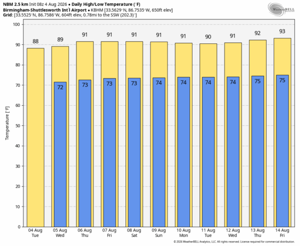
CALM PATTERN: A broad upper low remains parked over Georgia today, and that feature will being a few isolated showers to Alabama this afternoon. They will be most active over the eastern half of the state; West Alabama stays generally dry. Today’s high will be in the 87-92 degree range, which is below average for early August.
The upper low will fizzle in coming days and an upper ridge will build into the region, meaning highs returning to the low 90s over the latter half of the week. Like any summer day, a few widely scattered afternoon and evening showers or storms will be possible.
THE ALABAMA WEEKEND: Not much change; classic summer weather. Partly sunny days, a few spotty showers or storms around from noon to 9:00 p.m. and afternoon highs in the low 90s.
Same situation for early next week… there is some evidence showers and storms could increase late next week ahead of a surface front. See the video briefing for maps, graphics, and more details.
TROPICS: The Atlantic basin remains quiet and tropical storm formation is not expected for at least the next 7-10 days.
ON THIS DATE IN 2008: Severe storms moved across northern Illinois and Indiana with tornadoes and strong winds. With tornado sirens blaring, the game at Wrigley Field between Cubs and Astros was stopped as fans were told to evacuate to the lower concourse. Passengers at O’Hare International Airport were evacuated to lower levels of buildings as well.
Look for the next video briefing here by 4:00 this afternoon… enjoy the day!



