


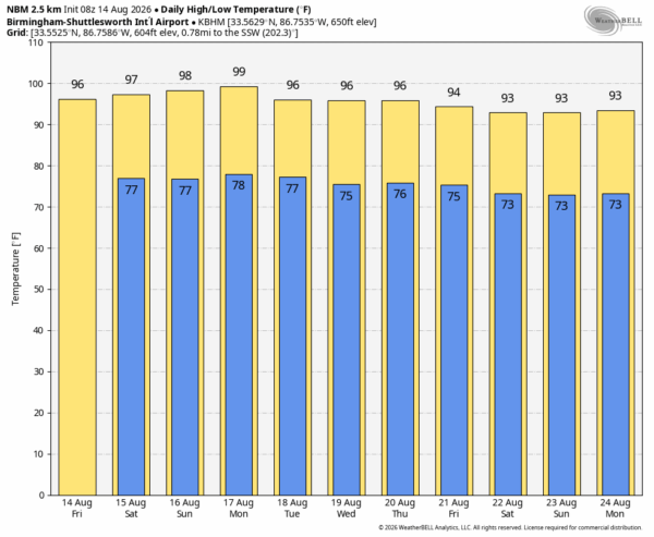
NEW DAY, OLD FORECAST: Alabama’s weather won’t change much through the weekend. Summer heat is the big story with afternoon highs remaining in the 95-100 degree range for most communities; the heat index will be over 100 degrees. An afternoon shower or thunderstorm is always possible on any summer day here, but they should be widely spaced as an upper ridge remains parked over the Deep South. Highest coverage of afternoon/evening storms will likely be over the eastern and southern counties of the state.
NEXT WEEK: Monday will likely be the hottest day of the week, followed by slightly lower heat levels as the upper ridge shifts slowly to the west. Afternoon highs will be in the low to mid 90s by Thursday and Friday, and coverage of scattered showers/storms should be a little higher by then. See the video briefing for maps, graphics, and more details.
TROPICS: NHC is watching two waves across the tropical Atlantic between the Lesser Antilles and the coast of Africa. The lead wave, Invest 92L, is approaching a region with strong winds aloft and dry air, and most likely won’t develop.
The trailing wave, Invest 94L, is located several hundred miles southwest of the Cabo Verde Islands is producing disorganized showers and thunderstorms. Environmental conditions are forecast to be generally conducive for gradual development, and a tropical depression could form late this week or this weekend while the wave moves westward or west-northwestward across the eastern and central tropical Atlantic. This feature will also encounter a hostile environment by early next week as it moves near the northern Leeward Islands.
No tropical storms or hurricanes are expected near the contiguous U.S. for at least the next 7-10 days.

ON THIS DATE IN 1969: Tropical Storm Camille formed just west of the Cayman Islands. It rapidly intensified, and by the time it reached western Cuba the next day, it was a category three hurricane. It would ultimately make landfall on the Mississippi Gulf Coast on August 17, 1969 as an historic, destructive category five hurricane.
Look for the next video briefing here by 3:00 this afternoon… enjoy the day!



